Crkvenica is a Bosnian river. It is a right bank tributary of the Vrbanja River.

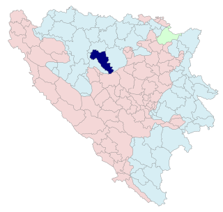
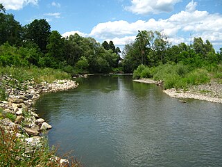
The Vrbanja is a river in Central Bosnia, Bosnia and Herzegovina; with Ugar, the largest right tributary of the Vrbas. Its basin covers an area of approximately 703.5 km2. It has significant hydropower potential. There are many different estimations of the Vrbanja's length, from 70.5 km and 84 km to 95.4 km.
Jakotina is a left tributary of the Vrbanja river. It rises on the north-eastern slopes of the mountains Čemernica in the area Rađići village. This locality is above the regional road Banja Luka - Skender Vakuf. The length of this river is about 20 kilometers. Along its course, in the 1970s there were at least 10 water-mills. Its mouth is in the Kotor Varoš, about 200 meters downstream from the old bazaar . After a watershed with Cvrcka, and tributaries of Ugar, Jakotina has a relatively short and deep canyon. The canyon spreads to the mouth Grabačovac, its richest tributary. Near Kotor Varoš there is also one small and one large waterfall. Large waterfall is called "Bobas"; its height is about seven metres.
Sadika is a tributary of the river Vrbanja in Bosnia and Herzegovina. It rises on the northeastern slopes of Zastinje Mountain, at 1,000 metres (3,300 ft) above sea level. The river's confluence with the Vrbanja is below Gigovići, a village close to the Kotor Varoš–Šiprage road, at 496 metres (1,627 ft) above sea level.
Bobovica is the richest tributary of upper flow of Vrbanja river, although it is marked on some maps as "Kruševica". However, the latter name is for another river about 30 kilometers downflow. Bobovica's length is around 12 km. Its mouth is in Kruševo Brdo. During the 1960s there were about 15 mills on this river, the mouth of which is in Obodnik.
Grabovica is a settlement in the Kotor Varoš Municipality, Republika Srpska, Bosnia and Herzegovina. It is located by the Vrbanja river, the new village on the mouth on Grabovička rijeka, and old one at around 3 km upstream of this Vrbanja's tributary. Grabovica is situated at an altitude of about 450 m, and the distance from Kotor Varos is about 23 km.
Čúdnić is a left, western tributary of the Vrbanja in Bosnia and Herzegovina. It flows to Panići village and empties into the village of Čudić in the village of Kruševo Brdo, below Arapovo Brdo. It springs on the southeastern slopes of the lower Vlašić's plateau, below the Ilomska and its tributaries. The spring is on a riverhead with the Kovačevića creek and the Ćorkovac creek. The tributary flows deep and fast; it is the local population's belief that the Čudnić is flowing over a part of the water of the Ilomska confluence.

The Cvrcka is a river which flows through Bosnia, the largest left bank tributary of Vrbanja river.
Obodnik is a village in the municipality of Kotor Varoš, Republika Srpska in Bosnia and Herzegovina. This settlement is located at the mouth of Kruševica and Vigošća in Vrbanja river. From this location Vrbanja valley expands into Večićko polje and the plateau around Vrbanjci. Highway M-4 runs through Obodnik. The road to Šiprage and Kruševo Brdo also runs from this village.

Zabrđe is a populated place in the Kotor Varoš municipality of central Republika Srpska, Bosnia and Herzegovina. It has been one of six municipalities in Kotor Varoš former County also.
Kruševica is the strongest right tributary of Vrbanja in central Bosnia. It rises from two streams whose source on the northeast slopes of the Očauš Mountain. The source is exposed to the Borja Mountain. On geographic maps as Kruševica is often marked an other river (Bobovica), whose estuary is around 20 miles upstream.

Borja is a mountain in central Bosnia, between Teslić town and Maslovare village. It spreads in the southeast – northwest, and from Uzlomac is divided on saddle Solila, through which passes main road M-4 (Banja Luka – Matuzići – Doboj, which exits on the M-17. The biggest part of this mountain lies in the municipalities of Teslić and Kotor Varoš.

Očauš is a mountain in central Bosnia, the majority in the municipalities of Kotor Varoš and Teslić, at an altitude of 1,402 meters.

Meokrnje is a mountain in Central Bosnia (Bosnia and Herzegovina, in the masiff chain of internal Dinaris mountains. This is the greatest elevation between Vlašić and Manjača - the northeast.
Radohova is a settlement in the Kotor Varoš Municipality, Republika Srpska entity, Bosnia and Herzegovina. The settlement includes the hamlets of Ulice, Letići, Lapići, Traljići, Kerkezi, Gigovići, Demići, and Dunići, located on the slopes of Zastijenje, and extend from the Ulički stream to the source of Demićka and the Djevojačka Ravan. Its length is ca. 6 km.
Crna River is one of the right-hand tributaries of the Vrbanja River in Bosnia and Herzegovina. It rises on the western slopes of Uzlomac.
Ćorkovići (Ћорковићи) is populated place in Bosnia and Herzegovina, Kotor Varoš Municipality in Republika Srpska. In 1991, in this village lived 175 inhabitants, and 2013. : 101.