Vaalharts Storage Weir

Last updated
Vaalharts Storage Weir
Location South Africa
Coordinates 28°06′54″S24°55′30″E / 28.115°S 24.925°E / -28.115; 24.925 Coordinates: 28°06′54″S24°55′30″E / 28.115°S 24.925°E / -28.115; 24.925

Vaalharts Storage Weir is a dam in South Africa. It was established in 1936. Vaalhartz Weir (alternative spelling) is located on the Vaal River approximately 100 km downstream of Bloemhof Dam and 13 km upstream of Warrenton. The main purpose of the dam is to divert water from the Vaal River (released from Bloemhof Dam) to the Vaalhartz Government Water Scheme as well as the Barkly Government Water Scheme. Water is also used for numerous small towns including Vryburg, Hartswater, Jan Kempdorp, Warrenton, Winsorton, Kipdam, Barkly West and Delportshoop.

South Africa Republic in the southernmost part of Africa

South Africa, officially the Republic of South Africa (RSA), is the southernmost country in Africa. It is bounded to the south by 2,798 kilometres (1,739 mi) of coastline of Southern Africa stretching along the South Atlantic and Indian Oceans; to the north by the neighbouring countries of Namibia, Botswana, and Zimbabwe; and to the east and northeast by Mozambique and Eswatini (Swaziland); and it surrounds the enclaved country of Lesotho. South Africa is the largest country in Southern Africa and the 25th-largest country in the world by land area and, with over 57 million people, is the world's 24th-most populous nation. It is the southernmost country on the mainland of the Old World or the Eastern Hemisphere. About 80 percent of South Africans are of Sub-Saharan African ancestry, divided among a variety of ethnic groups speaking different African languages, nine of which have official status. The remaining population consists of Africa's largest communities of European (White), Asian (Indian), and multiracial (Coloured) ancestry.

Vaal River river in South Africa

The Vaal River is the largest tributary of the Orange River in South Africa. The river has its source near Breyten in Mpumalanga province, east of Johannesburg and about 30 kilometres (19 mi) north of Ermelo and only about 240 kilometres (150 mi) from the Indian Ocean. It then flows westwards to its conjunction with the Orange River southwest of Kimberley in the Northern Cape. It is 1,120 kilometres (700 mi) long, and forms the border between Mpumalanga, Gauteng and North West Province on its north bank, and the Free State on its south.

Bloemhof Dam dam in South Africa

Bloemhof Dam is a dam in South Africa. It was originally known as the Oppermansdrif Dam when under construction during the late 1960s. It is located at the confluence of the Vaal River and the Vet River, on the border between the provinces North West and Free State. The dam wall has a total length of 4,270 metres (14,010 ft) The reservoir is very shallow, and therefore needs a large area to mean anything for water storage. The area around the reservoir (dam), has been a protected area, but because it lies on the border between provinces, these became two separate nature reserves. On the North West Province side lies the Bloemhof Dam Nature Reserve, on the Free State side is the Sandveld Nature Reserve.

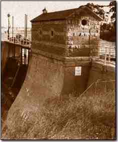
The main construction of the weir was completed in 1938 and was part of the government initiatives to alleviate unemployment following the depression of the 1930s.

In 1967, the weir was raised by 1.2m to its current height of 11m. It is a concrete barrage-type structure, 765m wide with numerous sluices. The sluices are of two types; some for the normal river releases and some for flood management purposes. The dam is designed to handle floods of up to 14200 m³/s.

After the raising of the dam in 1967, it has a storage capacity of 45 million m³. It diverts water into a concrete lined canal on the right flank with a capacity of 40 m³/s. This canal supplies water to approximately 37000 ha of irrigation, most of which is located in the Vaalhartz and Barkly Government Water Schemes.

See also

Related Research Articles

Hume Dam dam in Australia

Hume Dam, formerly the Hume Weir, is a major dam across the Murray River downstream of its junction with the Mitta River in the Riverina region of New South Wales, Australia. The dam's purpose includes flood mitigation, hydro-power, irrigation, water supply and conservation. The impounded reservoir is called Lake Hume, formerly the Hume Reservoir. It is a gated concrete gravity dam with four earth embankments and twenty-nine vertical undershot gated concrete overflow spillways.

Warragamba Dam dam on the Warragamba River, Australia

Warragamba Dam is a heritage-listed dam in Warragamba, Wollondilly Shire, New South Wales, Australia. It is a concrete gravity dam, which creates Lake Burragorang, the primary reservoir for water supply for the Australian city of Sydney, New South Wales.

Vaal Dam dam on the Vaal River in South Africa

The Vaal Dam in South Africa was constructed in 1938 and lies 77 km south of OR Tambo International Airport. The lake behind the dam wall has a surface area of about 320 square kilometres (120 sq mi) and is 47 meters deep. The Vaal Dam lies on the Vaal River, which is one of South Africa's strongest-flowing rivers. Other rivers flowing into the dam are the Wilge River, Klip River, Molspruit and Grootspruit. It has over 800 kilometres (500 mi) of shoreline and is South Africa's second biggest dam by area and the fourth largest by volume.

Gariep Dam dam on the Orange River in South Africa

Gariep Dam located in South Africa, near the town of Norvalspont, bordering the Free State and Eastern Cape provinces. Its primary purpose is for irrigation, domestic and industrial use as well as for power generation.

Nagarjuna Sagar Dam dam

Nagarjuna Sagar Dam is one of the world's largest and tallest Masonry dams built across the Krishna river at Nagarjuna Sagar which is in Nalgonda District, Telangana State, India. Constructed between 1955 and 1967, the dam created a water reservoir with gross storage capacity of 11.472 billion cubic metres. The dam is 590 feet (180 m) tall from its deepest foundation and 0.99 miles (1.6 km) long with 26 flood gates which are 42 feet (13 m) wide and 45 feet (14 m) tall.

Srisailam Dam dam

The Srisailam Dam is constructed across the Krishna River in between Kurnool district, Andhra Pradesh and mahabubnagar, Telangana, near Srisailam temple town and is the 2nd largest capacity working hydroelectric station in the country.

Goulburn Weir lake in Australia

Goulburn Weir is a weir built between 1887 and early 1891 across the Goulburn River near Nagambie, Victoria, Australia. It was the first major diversion structure built for irrigation development in Australia. The weir also forms Lake Nagambie where rowing regattas and waterskiing tournaments are held.

Fairbairn Dam dam in Australia

The Fairbairn Dam is an earthfill-filled embankment dam across the Nogoa River, located southwest of Emerald in Central Queensland, Australia. Constructed in 1972 for the primary purpose of irrigation, the impoundment created by the dam serves as one the major potable water supplies for the region and assists with some flood mitigation. Lake Maraboon with an active capacity of 1,301,000 ML (2.86×10¹¹ imp gal; 3.44×10¹¹ US gal) was formed by damming of the Nogoa River, and, in 2008, was Queensland's second largest dam. Maraboon is the Aboriginal for "where the black ducks fly".

Wyaralong Dam dam in Australia

The Wyaralong Dam is a mass concrete gravity dam with an un-gated spillway across the Teviot Brook that is located in the South East region of Queensland, Australia. The main purpose of the dam is for supply of potable water for the Scenic Rim region. The impounded reservoir is also called Wyaralong Dam. The dam was initiated by the Queensland Government in 2006 as a result of a prolonged drought which saw the catchment areas of South East Queensland's dams receive record low rain.

Sterkfontein Dam

The Sterkfontein Dam, located just outside the town of Harrismith, in the Free State, province of South Africa, is part of the Tugela-Vaal Water Project and the Drakensberg Pumped Storage Scheme, and located on the Nuwejaarspruit, a tributary of the Wilge River in the upper catchment area of the Vaal River. It is the second highest dam wall in South Africa and its highest earth fill dam.

Orange–Fish River Tunnel

The Orange–Fish Tunnel is an irrigation tunnel in central South Africa.

Grootdraai Dam is a combined gravity and earth-fill type dam located on the Vaal River, near Standerton, Mpumalanga, South Africa. It was established in 1981.

Knellpoort Dam is a combined gravity & arch type dam located on the Riet Spruit, near Wepener, Free State, South Africa. It was established in 1989. Due to siltation, the storage capacity of the Welbedacht Dam reduced rapidly from the original 115 million m3 to approximately 16 million m3 during the twenty years since completion. This reduction in storage created problems in meeting the Bloemfontein water demand at an acceptable level of reliability and as a result, the 50 m high Knellpoort Dam was completed in 1989. It was the first arch gravity roller compacted concrete (RCC) dam in the world and comprises almost 64 600 m3 rollcrete and 14 200 m3 concrete with a gross storage capacity of 136 million m3.

Welbedacht Dam is a concrete-gravity type dam situated in South Africa, and was established in 1973. Bloemfontein is the sixth-largest city in South Africa, with a population around 300 000. It is situated in the Modder River catchment, which has insufficient water resources to meet the growing water requirements. The water supply to Bloemfontein is, therefore, augmented from the adjacent Caledon River by means of the Caledon - Modder River Government Water Scheme (CMRGWS).

Menindee Lakes

The Menindee Lakes is a chain of shallow ephemeral freshwater lakes connected to the Darling River to form a storage system. The lakes lie in the far west region of New South Wales, Australia, near the town of Menindee.

Clifton, Rawcliffe and Poppleton Ings

Clifton, Rawcliffe and Poppleton ings are temporary storage area for water that flows down the River Ouse in York, England.

The Vaalharts Valley is located in the north-east corner of the Northern Cape province of South Africa, bordering the North West province. It gets its name because it is located between two rivers, the Vaal and the Harts. Because of its advantageous position between the two rivers, an irrigation scheme was built in the Vaalharts Valley in the 1930s.

Gogeldrie Weir weir in New South Wales, Australia

The Gogeldrie Weir is a heritage-listed former weir and now recreation area and weir at Murrumbidgee River near Narrandera, Leeton Shire, New South Wales, Australia. It was designed and built by WC & IC from 1958 to 1959. It was added to the New South Wales State Heritage Register on 2 April 1999.

References