
Mahikeng, formerly known as Mafikeng and alternatively known as Mafeking, is the capital city of the North West province of South Africa.
Mmabatho is the former capital of the North-West Province of South Africa. During the apartheid era, it was the capital of the former "Bantustan" of Bophuthatswana, separated from the adjacent Mafeking which temporarily remained outside Bophuthatswana.
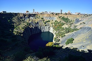
Kimberley is the capital and largest city of the Northern Cape province of South Africa. It is located approximately 110 km east of the confluence of the Vaal and Orange Rivers. The city has considerable historical significance due to its diamond mining past and the siege during the Second Anglo-Boer war. British businessmen Cecil Rhodes and Barney Barnato made their fortunes in Kimberley, and Rhodes established the De Beers diamond company in the early days of the mining town.

The Northern Cape is the largest and most sparsely populated province of South Africa. It was created in 1994 when the Cape Province was split up. Its capital is Kimberley. It includes the Kalahari Gemsbok National Park, part of the Kgalagadi Transfrontier Park and an international park shared with Botswana. It also includes the Augrabies Falls and the diamond mining regions in Kimberley and Alexander Bay.

North West is a province of South Africa. Its capital is Mahikeng. The province is located to the west of the major population centre and province of Gauteng and south of Botswana.

Paarl is a town with 285,574 inhabitants in the Western Cape province of South Africa. It is the largest town in the Cape Winelands. Due to the growth of the Mbekweni township, it is now a de facto urban unit with Wellington. It is situated about 60 kilometres (37 mi) northeast of Cape Town in the Western Cape Province and is known for its scenic environment and viticulture and fruit-growing heritage. Paarl is a colonial town founded by Dutch colonists who seized Khoikhoi lands, many Khoi died in the colonisation process. Paarl's colonial society was dependent on enslaved people.

Bellville is a suburb of Cape Town, South Africa, and is part of the city's Northern Suburbs region. Having formerly been an independent city, it was later incorporated into the City of Cape Town Metropolitan Municipality, which is located in the Western Cape province of South Africa.

The N1 is a national route in South Africa that runs from Cape Town through Bloemfontein, Johannesburg, Pretoria and Polokwane to Beit Bridge on the border with Zimbabwe. It forms the first section of the famed Cape to Cairo Road.
The High Court of South Africa is a superior court of law in South Africa. It is divided into nine provincial divisions, some of which sit in more than one location. Each High Court division has general jurisdiction over a defined geographical area in which it is situated. The decisions of a division are binding on magistrates' courts within its area of jurisdiction. The High Court has jurisdiction over all matters, but it usually only hears civil matters involving more than 400,000 rand, and serious criminal cases. It also hears any appeals or reviews from magistrates' courts and other lower courts.

Vryburg is a large agricultural town with a population of 63 260 situated in the Dr Ruth Segomotsi Mompati District Municipality of the North West Province of South Africa. It is the seat and the industrial and agricultural heartland of the district of the Bophirima region.

Warrenton is an agricultural town of approximately 22,588 people in the Northern Cape province of South Africa, situated 70 kilometres (40 mi) north of Kimberley on the Vaal River.

The R49 is a provincial route in North West, South Africa that connects Mahikeng with the Botswana border at Kopfontein near Gaborone, via Zeerust.

De Aar is a town in the Northern Cape province of South Africa. It has a population of around 42,000 inhabitants.

The N12 is a national route in South Africa which runs from George through Beaufort West, Kimberley, Klerksdorp and Johannesburg to eMalahleni.

The A1 highway in Botswana is a road that runs from the Zimbabwean border near Ramokgwebana through Francistown, Mahalapye, Palapye, Gaborone and Lobatse, to Ramatlabama at the border with South Africa. Crossing the Ramokgwebana River into Zimbabwe, it continues as the A7 to Bulawayo. On the South African end it continues as the N18 to Mahikeng.

The N18 is a national route in South Africa which runs from Warrenton through Vryburg and Mahikeng to Ramatlabama on the border with Botswana.
Ramatlabama is a village and railway station 25 kilometres (16 mi) north of Mafikeng, in the North West province of South Africa. It is located on the border with Botswana, and serves as a border post for road and rail traffic. At the time of the 2011 census, Ramatlabama along with the adjoining settlement of Miga had a total population of 2,046. The Botswana side of the border is also known as Ramatlabama.

The Cairo–Cape Town Highway is Trans-African Highway 4 in the transcontinental road network being developed by the United Nations Economic Commission for Africa (UNECA), the African Development Bank (AfDB), and the African Union. The route has a length of 10,228 km (6,355 mi) and links Cairo in Egypt to Cape Town in South Africa.

Leeu-Gamka is a small town in the Western Cape province of South Africa, located 355 kilometres (221 mi) north-east of Cape Town in the Karoo.
The R708 is a Regional Route in South Africa that connects Jan Kempdorp in the Northern Cape with Clocolan in the Free State via Christiana, Hertzogville, Bultfontein, Theunissen, Winburg and Marquard.


