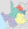
The Sarah Baartman District Municipality, formerly the Cacadu District Municipality, is situated in the western part of the Eastern Cape province of South Africa, covering an area of 58,242 square kilometres. The area of the district municipality includes seven local municipalities. The seat is the city of Gqeberha, although Gqeberha is not itself in the district. As of 2011, the languages most spoken among the 388,201 inhabitants were Xhosa and Afrikaans. The district code is DC10.

The Lejweleputswa District Municipality is one of the 5 districts of the Free State province of South Africa. The seat of the municipality is Welkom. As of 2011, a majority of its 657,019 residents speak Sotho. The district code is DC18. Lejweleputswa is a Sesotho word meaning "grey rock".
The Xhariep District Municipality is one of the 5 districts of the Free State province of South Africa. The municipality is the largest in the Free State geographically and is known for its vast land. It is home to the largest dam in the county, the Gariep Dam, and has two mines, situated in Jagersfontein and Koffiefontein. The natural resources and the geographical position of the municipality make it a site with good potential for investment and development. The seat is Trompsburg. As of 2011, the largest language group is Sotho who make up 45.3% of the total population of 146,259. The district code is DC16.

The Namakwa District Municipality is one of the 5 districts of the Northern Cape province of South Africa. The seat of Namakwa is Springbok and the region is also known as Little Namaqualand. As of 2011, a majority of its 108,118 residents speak Afrikaans. The district code is DC6.

The ZF Mgcawu District Municipality, known before 1 July 2013 as the Siyanda District Municipality, is one of the 5 districts of the Northern Cape province of South Africa. The seat of the municipality is Upington. As of 2011, the majority (76%) of its 236,783 residents speak Afrikaans. The district code is DC8.

The John Taolo Gaetsewe District Municipality, formerly the Kgalagadi District Municipality, is one of the five districts of the Northern Cape province of South Africa. The seat of the authority is Kuruman. As of 2011, the majority of its 176,899 residents speak Setswana. The district code is DC45.

The Joe Gqabi District Municipality is one of the seven districts of the Eastern Cape province of South Africa. The seat is Barkly East. As of 2011, the majority of its 349,768 inhabitants spoke isiXhosa.

The OR Tambo District Municipality is one of the seven districts of the Eastern Cape province of South Africa. It is within the Wild Coast Region. The seat is Mthatha. As of 2011, the vast majority (94%) of its 1,364,943 inhabitants spoke isiXhosa. The district is named after Oliver Tambo. The district code is DC15.

The Amathole District Municipality is one of the 7 districts of the Eastern Cape province of South Africa. The seat is East London. As of 2011, over 90% of its 892,637 inhabitants spoke isiXhosa. The district code is DC12. Amathole means "calves", the name of the mountain range and forest which forms the northern boundary of the district.

The Dr Kenneth Kaunda District Municipality, formerly the Southern District Municipality, is one of the 4 districts of the North West province of South Africa. The seat of the municipality is Klerksdorp. As of 2016, a plurality of its 742,821 residents speak Setswana. The majority of its residents live in the City of Matlosana. The district code is DC40. The district was formerly known as the Southern District Municipality. It is named after Kenneth Kaunda, the first President of Zambia.

The Dr Ruth Segomotsi Mompati District Municipality, formerly the Bophirima District Municipality, is one of the 4 districts of the North West province of South Africa. The seat of the municipality is Vryburg. As of 2011, the majority of its 439,637 residents speak Setswana. The district code is DC39. It is South Africa's largest beef producing district, with Hereford cattle the most popular. It is sometimes called "the Texas of South Africa". Maize and peanuts are important crops produced in the district. The district was renamed after the former Mayor of Vryburg, Ruth Mompati.

The Sekhukhune District Municipality is one of the 5 districts of the Limpopo province of South Africa. The seat is Groblersdal. As of 2011, the majority of its 1,076,840 inhabitants spoke Sepedi. The district code is DC47.
The Capricorn District Municipality is one of the 5 districts of the Limpopo province of South Africa. The district is named after the Tropic of Capricorn which runs through it. The capital is Polokwane. As of 2011, the vast majority of its 1,261,463 residents spoke Northern Sotho as their home language. The district code is DC35.

The Fezile Dabi District Municipality, formerly known as the Northern Free State District Municipality, is one of the 5 districts of the Free State province of South Africa. The seat is Sasolburg. As of 2011, a majority of its 460,289 residents spoke Sesotho. The district code is DC20.
Frances Goitsemang Baard OMSS OLG was a South African trade unionist, organiser for the African National Congress Women's League and a Patron of the United Democratic Front, who was commemorated in the renaming of the Diamantveld District Municipality (Kimberley) as the Frances Baard District Municipality. Schoeman Street in Pretoria was also renamed in her honour. This heroine is the reason we celebrate National Women's Day today in South Africa.
Sol Plaatje Municipality is a local municipality within the Frances Baard District Municipality, in the Northern Cape province of South Africa. It is named after Sol T. Plaatje. It includes the diamond mining city of Kimberley.

Phokwane Municipality is a local municipality within the Frances Baard District Municipality, in the Northern Cape province of South Africa. The name means "small Billy goat" in Setswana.

Magareng Municipality is a local municipality within the Frances Baard District Municipality, in the Northern Cape province of South Africa.

Dikgatlong Municipality is a local municipality within the Frances Baard District Municipality, in the Northern Cape province in South Africa. Dikgatlong is a Setswana name meaning "confluence", and refers to the place where the Harts and Vaal rivers flow into each other in Delportshoop. The name was used as early as 1700.

Kagisano–Molopo Municipality is a local municipality within the Dr Ruth Segomotsi Mompati District Municipality, in the North West province of South Africa. It was created at the local government elections of 18 May 2011 by merging the Kagisano and Molopo municipalities.


