Emthanjeni Local Municipality

Last updated

Emthanjeni
Emthanjeni CoA.png
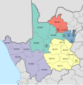
Map of the Northern Cape with Emthanjeni highlighted (2011).svg
Location in the Northern Cape
Coordinates: 30°40′S24°0′E / 30.667°S 24.000°E / -30.667; 24.000
Country South Africa
Province Northern Cape
District Pixley ka Seme
Seat De Aar
Wards 8
Government
[1]
  Type Municipal council
  MayorBoy Kenneth Markman
Area
  Total13,472 km2 (5,202 sq mi)
Population
 (2011) [2]
  Total42,356
  Density3.1/km2 (8.1/sq mi)
Racial makeup (2011)
[2]
   Black African 33.2%
   Coloured 57.7%
   Indian/Asian 0.6%
   White 8.0%
First languages (2011)
[2]
   Afrikaans 70.3%
   Xhosa 23.8%
   English 2.3%
  Other3.6%
Time zone UTC+2 (SAST)
Municipal codeNC073
Website emthanjeni.co.za

Emthanjeni Municipality (Afrikaans : Emthanjeni Munisipaliteit; Xhosa : uMasipala wase Emthanjeni) is a local municipality within the Pixley ka Seme District Municipality, in the Northern Cape province of South Africa. Emthanjeni is a Xhosa word meaning "vein", symbolising the importance of an underground water supply system to the area. [3] It is also a translation of the name of the municipality's seat, De Aar.
Contents

Main places

The 2011 census divided the municipality into the following main places: [4]

PlaceCodeArea (km2)PopulationMost spoken language
Britstown 371002 61.473,843Afrikaans
De Aar 371004 84.2323,760Afrikaans
Hanover 371006 80.774,594Afrikaans
Mziwabantu 371001 1,081,302 Xhosa/Afrikaans
Nonzwakazi 371005 1.276,230Xhosa
Remainder of the municipality 371003 13,243.482,626Afrikaans

Politics

The municipal council consists of fifteen members elected by mixed-member proportional representation. Eight councillors are elected by first-past-the-post voting in eight wards, while the remaining seven are chosen from party lists so that the total number of party representatives is proportional to the number of votes received. In the election of 1 November 2021 the African National Congress (ANC) won a majority of nine seats on the council. [5] [6]

The following table shows the results of the election.

Emthanjeni local election, 1 November 2021
PartyVotesSeats
WardListTotal %WardListTotal
African National Congress 6,7846,80913,59360.3%729
Democratic Alliance 2,9323,0555,98726.6%134
Economic Freedom Fighters 4845481,0324.6%011
Patriotic Alliance 3806089884.4%011
Freedom Front Plus 2602945542.5%000
Independent candidates 3863861.7%00
Total11,22611,31422,5408715
Valid votes11,22611,31422,54098.5%
Spoilt votes 1781573351.5%
Total votes cast11,40411,47122,875
Voter turnout11,566
Registered voters22,544
Turnout percentage51.3%

Related Research Articles

<span class="mw-page-title-main">Inxuba Yethemba Local Municipality</span> Local municipality in Eastern Cape, South Africa

Inxuba Yethemba Municipality, formerly known as Cradock Municipality, is a local municipality within the Chris Hani District Municipality, in the Eastern Cape province of South Africa. The seat is Cradock.

<span class="mw-page-title-main">Ubuntu Local Municipality</span> Local municipality in Northern Cape, South Africa

Ubuntu Municipality is a local municipality within the Pixley ka Seme District Municipality, in the Northern Cape province of South Africa. Its seat is Victoria West. Other towns in the municipality are Richmond, Loxton and two small railway villages Hutchinson and Merriman.

<span class="mw-page-title-main">Umsobomvu Local Municipality</span> Local municipality in Northern Cape, South Africa

Umsobomvu Municipality is a local municipality within the Pixley ka Seme District Municipality, in the Northern Cape province of South Africa.

<span class="mw-page-title-main">Renosterberg Local Municipality</span> Local municipality in Northern Cape, South Africa

Renosterberg Municipality is a local municipality within the Pixley ka Seme District Municipality, in the Northern Cape province of South Africa.

<span class="mw-page-title-main">Thabazimbi Local Municipality</span> Local municipality in Limpopo, South Africa

Thabazimbi Municipality is a local municipality within the Waterberg District Municipality, in the Limpopo province of South Africa. The seat is Thabazimbi.

<span class="mw-page-title-main">City of Matlosana</span> Local municipality in North West, South Africa

The City of Matlosana, formerly the City Council of Klerksdorp, is a local municipality within the Dr Kenneth Kaunda District Municipality, in the North West province of South Africa.

<span class="mw-page-title-main">Kgatelopele Local Municipality</span> Local municipality in Northern Cape, South Africa

Kgatelopele Municipality is a local municipality within the ZF Mgcawu District Municipality, in the Northern Cape province of South Africa. Kgatelopele is a Setswana name meaning "progress".

<span class="mw-page-title-main">Phokwane Local Municipality</span> Local municipality in Northern Cape, South Africa

Phokwane Municipality is a local municipality within the Frances Baard District Municipality, in the Northern Cape province of South Africa. The name means "small Billy goat" in Setswana.

<span class="mw-page-title-main">Camdeboo Local Municipality</span> Former local municipality in Eastern Cape, South Africa

Camdeboo Local Municipality was a local municipality in the Sarah Baartman District Municipality of the Eastern Cape in South Africa. After municipal elections on 3 August 2016 it was merged into the larger Dr Beyers Naudé Local Municipality.

<span class="mw-page-title-main">Ga-Segonyana Local Municipality</span> Local municipality in Northern Cape, South Africa

Ga-Segonyana Municipality is a local municipality within the John Taolo Gaetsewe District Municipality, in the Northern Cape province of South Africa.

<span class="mw-page-title-main">Khâi-Ma Local Municipality</span> Local municipality in Northern Cape, South Africa

Khâi-Ma Municipality is a local municipality within the Namakwa District Municipality, in the Northern Cape province of South Africa. Khâi-Ma is a Khoekhoe word meaning "to stand up".

<span class="mw-page-title-main">Ikwezi Local Municipality</span> Former local municipality in Eastern Cape, South Africa

Ikwezi Local Municipality was a local municipality in the Sarah Baartman District Municipality of the Eastern Cape in South Africa. Ikwezi is an isiXhosa name that means "morning star". After municipal elections on 3 August 2016 it was merged into the larger Dr Beyers Naudé Local Municipality.

<span class="mw-page-title-main">Emalahleni Local Municipality, Eastern Cape</span> Local municipality in Eastern Cape, South Africa

Emalahleni Municipality is a local municipality within the Chris Hani District Municipality, in the Eastern Cape province of South Africa. Emalahleni is an isiXhosa word meaning "a place of coal".

<span class="mw-page-title-main">Dikgatlong Local Municipality</span> Local municipality in Northern Cape, South Africa

Dikgatlong Municipality is a local municipality within the Frances Baard District Municipality, in the Northern Cape province in South Africa. Dikgatlong is a Setswana name meaning "confluence", and refers to the place where the Harts and Vaal rivers flow into each other in Delportshoop. The name was used as early as 1700.

<span class="mw-page-title-main">Inkwanca Local Municipality</span> Former local municipality in Eastern Cape, South Africa

Inkwanca Local Municipality was a local municipality that forms part of the Chris Hani District Municipality in the Eastern Cape province of South Africa. Inkwanca is an isiXhosa name meaning cold. The municipal area is the coldest area in the country and the lowest temperatures are recorded in the area every year. After municipal elections on 3 August 2016 it was merged into the larger Enoch Mgijima Local Municipality.

<span class="mw-page-title-main">Ntabankulu Local Municipality</span> Local municipality in Eastern Cape, South Africa

Ntabankulu Municipality is a local municipality within the Alfred Nzo District Municipality, in the Wild Coast Region of the Eastern Cape province of South Africa. Ntabankulu is an isiXhosa word meaning "great or big mountain", since the municipal area is mountainous in character.

<span class="mw-page-title-main">Nkonkobe Local Municipality</span> Former local municipality in Eastern Cape, South Africa

Nkonkobe Local Municipality was an administrative area in the Amatole District of the Eastern Cape in South Africa. The municipality is named after the Winterberg mountain range, Nkonkobe in isiXhosa. The seat, as well as most offices, of the Municipality are in Fort Beaufort, but the Council's chambers in Alice are generally used for council meetings, being better equipped. Other towns served by the municipality are Seymour, Balfour, Hogsback and Middledrift. After municipal elections on 3 August 2016 it was merged into the larger Raymond Mhlaba Local Municipality.

<span class="mw-page-title-main">Sakhisizwe Local Municipality</span> Local municipality in Eastern Cape, South Africa

Sakhisizwe Municipality is a local municipality within the Chris Hani District Municipality, in the Eastern Cape province of South Africa. Sakhisizwe is an isiXhosa word meaning "we are building the nation".

<span class="mw-page-title-main">Tsolwana Local Municipality</span> Former local municipality in Eastern Cape, South Africa

Tsolwana Local Municipality was an administrative area in the Chris Hani District of the Eastern Cape in South Africa. Tsolwana is an isiXhosa name which means "something with a sharp ending or a tip", referring the mountains around the whole area. After municipal elections on 3 August 2016 it was merged into the larger Enoch Mgijima Local Municipality.

<span class="mw-page-title-main">Lukhanji Local Municipality</span> Former local municipality in Eastern Cape, South Africa

Lukhanji Local Municipality was an administrative area in the Chris Hani District of the Eastern Cape in South Africa. Lukhanji is a Xhosa name for the mountain that runs from the eastern side of Queenstown to the western side. After municipal elections on 3 August 2016 it was merged into the larger Enoch Mgijima Local Municipality.

References

  1. "Contact list: Executive Mayors". Government Communication & Information System. Archived from the original on 14 July 2010. Retrieved 22 February 2012.
  2. 1 2 3 "Statistics by place". Statistics South Africa. Retrieved 27 September 2015.
  3. South African Languages - Place names
  4. Lookup Tables - Statistics South Africa [ permanent dead link ]
  5. "Results Summary - All Ballots" (PDF). Electoral Commission of South Africa. 8 November 2021. Retrieved 12 November 2021.
  6. "Seat Calculation Detail" (PDF). Electoral Commission of South Africa. 8 November 2021. Retrieved 12 November 2021.