Dawid Kruiper Local Municipality

Last updated
Dawid Kruiper Local Municipality
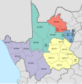
Map of the Northern Cape with Dawid Kruiper highlighted (2016).svg
Country South Africa
Province Northern Cape
District ZF Mgcawu
Seat Upington
Government
  Type Municipal council
Area
[1]
  Total44,231 km2 (17,078 sq mi)
Population
 (2011) [1]
  Total100,497
  Density2.3/km2 (5.9/sq mi)
Time zone UTC+2 (SAST)
Municipal codeNC087

Dawid Kruiper Municipality (Afrikaans : Dawid Kruiper Munisipaliteit) is a local municipality within the ZF Mgcawu District Municipality, in the Northern Cape province of South Africa. It was established after the August 2016 local elections by merging the Mier and //Khara Hais local municipalities. [2] The municipality is named after the San politician Dawid Kruiper.
Contents

Politics

The municipal council consists of thirty-three members elected by mixed-member proportional representation. Seventeen councillors are elected by first-past-the-post voting in seven wards, while the remaining sixteen are chosen from party lists so that the total number of party representatives is proportional to the number of votes received. In the election of 1 November 2021 the African National Congress (ANC) won a majority of eighteen seats on the council. [3] [4] [5]

The following table shows the results of the election.

Dawid Kruiper local election, 1 November 2021
PartyVotesSeats
WardListTotal %WardListTotal
African National Congress 17,47017,26234,73255.1%14418
Democratic Alliance 10,99111,16922,16035.2%3912
Khoisan Revolution9271,0171,9443.1%011
Freedom Front Plus 7867711,5572.5%011
Economic Freedom Fighters 5235561,0791.7%011
Congress of the People 3053656701.1%000
Independent South African National Civic Organisation1661683340.5%000
African Christian Democratic Party 1471232700.4%000
Africa Restoration Alliance 72681400.2%000
Patriotic Alliance 63630.1%00
African Transformation Movement 1528430.1%000
Total31,46531,52762,992171633
Valid votes31,46531,52762,99298.4%
Spoilt votes 4905551,0451.6%
Total votes cast31,95532,08264,037
Voter turnout32,259
Registered voters59,509
Turnout percentage54.2%

Related Research Articles

<span class="mw-page-title-main">Inxuba Yethemba Local Municipality</span> Local municipality in Eastern Cape, South Africa

Inxuba Yethemba Local Municipality, formerly known as Cradock Local Municipality, is a local municipality in Chris Hani District Municipality, Eastern Cape. The seat is Cradock.

<span class="mw-page-title-main">Mier Local Municipality</span> Local municipality in Northern Cape, South Africa

Mier was a local municipality within the ZF Mgcawu District Municipality in the Northern Cape province of South Africa. Its area includes the South African portion of one of the world's largest conservation areas, the Kgalagadi Transfrontier Park. The main settlement in the municipality is the town of Rietfontein.

<span class="mw-page-title-main">Ubuntu Local Municipality</span> Local municipality in Northern Cape, South Africa

Ubuntu Municipality is a local municipality within the Pixley ka Seme District Municipality, in the Northern Cape province of South Africa. Its seat is Victoria West. Other towns in the municipality are Richmond, Loxton and two small railway villages Hutchinson and Merriman.

<span class="mw-page-title-main">Siyancuma Local Municipality</span> Local municipality in Northern Cape, South Africa

Siyancuma Municipality is a local municipality within the Pixley ka Seme District Municipality, in the Northern Cape province of South Africa.

<span class="mw-page-title-main">Emthanjeni Local Municipality</span> Local municipality in Northern Cape, South Africa

Emthanjeni Municipality is a local municipality within the Pixley ka Seme District Municipality, in the Northern Cape province of South Africa. Emthanjeni is a Xhosa word meaning "vein", symbolising the importance of an underground water supply system to the area. It is also a translation of the name of the municipality's seat, De Aar.

<span class="mw-page-title-main">//Khara Hais Local Municipality</span> Local municipality in Northern Cape, South Africa

//Khara Hais Local Municipality was a local municipality in the Northern Cape province of South Africa. It fell within the ZF Mgcawu District Municipality and governed the town of Upington and surrounding rural areas. As of 2011 the municipality had a population of approximately 93,500 people, and covered an area of 21,780 square kilometres (8,410 sq mi). The unusual spelling of the name comes from the original transcription of the Khwe language name, where the click consonant became "//".

<span class="mw-page-title-main">Kgatelopele Local Municipality</span> Local municipality in Northern Cape, South Africa

Kgatelopele Municipality is a local municipality within the ZF Mgcawu District Municipality, in the Northern Cape province of South Africa. Kgatelopele is a Setswana name meaning "progress".

<span class="mw-page-title-main">Phokwane Local Municipality</span> Local municipality in Northern Cape, South Africa

Phokwane Municipality is a local municipality within the Frances Baard District Municipality, in the Northern Cape province of South Africa. The name means "small Billy goat" in Setswana.

<span class="mw-page-title-main">Khâi-Ma Local Municipality</span> Local municipality in Northern Cape, South Africa

Khâi-Ma Municipality is a local municipality within the Namakwa District Municipality, in the Northern Cape province of South Africa. Khâi-Ma is a Khoekhoe word meaning "to stand up".

<span class="mw-page-title-main">Kai ǃGarib Local Municipality</span> Local municipality in Northern Cape, South Africa

Kai ǃGarib Municipality is a local municipality within the ZF Mgcawu District Municipality, in the Northern Cape province of South Africa. The name Kai ǃGarib originates from the Khoekhoe language and means "big great river", referring to the Orange River that flows through the area.

uMfolozi Local Municipality Local municipality in KwaZulu-Natal, South Africa

uMfolozi Local Municipality is a local municipality within the King Cetshwayo District Municipality of KwaZulu-Natal in South Africa. It is situated around the town of KwaMbonambi, to the north of Richard's Bay, stretching from the Indian Ocean to the edge of the Hluhluwe–Imfolozi Park.

<span class="mw-page-title-main">ǃKheis Local Municipality</span> Local municipality in Northern Cape, South Africa

ǃKheis Municipality is a local municipality within the ZF Mgcawu District Municipality, in the Northern Cape province of South Africa. ǃKheis is a Khoikhoi name meaning "a place where you live, or a home". The municipality is named in recognition of the Khoekhoe people who were the first permanent dwellers of the area.

The Swartland Local Municipality consists of twenty-three members elected by mixed-member proportional representation. Twelve councillors are elected by first-past-the-post voting in twelve wards, while the remaining eleven are chosen from party lists so that the total number of party representatives is proportional to the number of votes received. In the election of 1 November 2021 the Democratic Alliance (DA) obtained a majority of fourteen seats on the council.

The Witzenberg Local Municipality consists of twenty-three members elected by mixed-member proportional representation. Twelve councillors are elected by first-past-the-post voting in twelve wards, while the remaining eleven are chosen from party lists so that the total number of party representatives is proportional to the number of votes received.

The Theewaterskloof Local Municipality council consists of twenty-seven members elected by mixed-member proportional representation. Fourteen councillors are elected by first-past-the-post voting in fourteen wards, while the remaining thirteen are chosen from party lists so that the total number of party representatives is proportional to the number of votes received. In the election of 1 November 2021, no party won a majority.

The Mossel Bay Local Municipality council consists of twenty-nine members elected by mixed-member proportional representation. Fifteen councillors are elected by first-past-the-post voting in fifteen wards, while the remaining fourteen are chosen from party lists so that the total number of party representatives is proportional to the number of votes received.

The Mangaung Metropolitan Municipality council consists of one hundred and one members elected by mixed-member proportional representation. Fifty-one councillors are elected by first-past-the-post voting in fifty-one wards, while the remaining fifty are chosen from party lists so that the total number of party representatives is proportional to the number of votes received.

The City of Ekurhuleni Metropolitan Municipality council consists of 224 members elected by mixed-member proportional representation. 112 are elected by first-past-the-post voting in 112 wards, while the remaining 112 are chosen from party lists so that the total number of party representatives is proportional to the number of votes received. In the election of 1 November 2021, no party obtained a majority of seats on the council.

The council of the Dr Beyers Naudé Local Municipality is elected every five years by a system of mixed-member proportional representation. Twelve of the twenty-four councillors are elected by first-past-the-post voting from individual wards, while the other twelve are appointed from party lists so that the total number of party representatives is proportional to the number of votes received. By-elections are held to replace the councillors elected by wards if a vacancy occurs.

The Dawid Kruiper Local Municipality council was formed in 2016 and consists of thirty-three members elected by mixed-member proportional representation. Seventeen councillors are elected by first-past-the-post voting in seventeen wards, while the remaining sixteen are chosen from party lists so that the total number of party representatives is proportional to the number of votes received. In the election of 1 November 2021 the African National Congress (ANC) won a majority of eighteen seats.

References

  1. 1 2 Sum of the statistics from Census 2011 for Mier, //Khara Hais.
  2. "The Local Government Handbook" . Retrieved 6 August 2016.
  3. "Election Result Table for LGE2021 — Dawid Kruiper". wikitable.frith.dev. Retrieved 2021-11-12.
  4. "Results Summary - All Ballots" (PDF). Electoral Commission of South Africa. 8 November 2021. Archived (PDF) from the original on 2021-11-12. Retrieved 12 November 2021.
  5. "Seat Calculation Detail" (PDF). Electoral Commission of South Africa. 8 November 2021. Archived (PDF) from the original on 2021-11-12. Retrieved 12 November 2021.

28°27′36″S21°13′48″E / 28.4600°S 21.2300°E / -28.4600; 21.2300