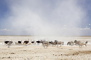
Etosha National Park is a national park in northwestern Namibia. It was proclaimed a game reserve in March 1907 in Ordinance 88 by the Governor of German South West Africa, Dr. Friedrich von Lindequist. It was designated as Wildschutzgebiet in 1958, and was elevated to the status of a national park in 1967 by an act of parliament of the Republic of South Africa. It spans an area of 22,270 km2 (8,600 sq mi) and gets its name from the large Etosha pan which is almost entirely within the park. The Etosha pan covers 23% of the total area of the National Park. The park is home to hundreds of species of mammals, birds and reptiles, including several threatened and endangered species such as the black rhinoceros.

Kestell is a small maize farming town in the Free State province of South Africa.

Vredefort is a small farming town in the Free State province of South Africa that used to farm with cattle, peanuts, sorghum, sunflowers and maize. It is home to at least 50,000 residents.

Breyten is a small farming town in Mpumalanga, South Africa and is situated at the foot of Klipstapel, the highest point on the watershed between the westward flowing Vaal River system and the eastward flowing Olifants and Komati River systems. The original farm, Bothasrus on which the town is built was given to Lukas Potgieter as compensation for losing a leg during the first Boer War. He later sold the farm to field-cornet Nicolaas Breytenbach, who formed the village in his own name.

Balfour is a small gold mining and maize farming town in Mpumalanga, South Africa.

Montagu is a town in the Western Cape province of South Africa, about 180 kilometres (110 mi) from Cape Town in western Little Karoo. It is named after former secretary of the Cape Colony, John Montagu, but was once known as Agter Cogman’s Kloof, Cogman’s Kloof linking the town and railway station. It is situated at the confluence of the Keisie and Kingna rivers.

Somerset West is a town in the Western Cape, South Africa. Organisationally and administratively it is included in the City of Cape Town metropolitan municipality as a suburb in the Helderberg area, about 50 kilometres (30 mi) east of Cape Town central city area, and bordering on Strand. The town is overlooked by the Helderberg Mountain, a part of the Hottentots-Holland range of mountains. The vehicle registration code for Somerset West is CFM and the post code is 7130 for street addresses, and 7129 for post office boxes.

Munroe Island or Mundrothuruthu is an inland island group located at the confluence of Ashtamudi Lake and the Kallada River, in Kollam district, Kerala, South India. It is a group of eight small islets comprising a total area of about 13.4 sqkm. The island, accessible by road, rail and inland water navigation, is about 25 kilometres (16 mi) from Kollam by road, 38 kilometres (24 mi) north from Paravur, 12 kilometres (7.5 mi) west from Kundara and about 25 kilometres (16 mi) from Karunagapally. As of the 2011 Indian census, the administrative village of Mundrothuruth has a total population of 9599, consisting of 4636 males and 4963 females.

Bathurst is about 12 kilometres (7.5 mi) inland from Port Alfred, on the R67 road, in the Eastern Cape province of South Africa, and is named after Henry Bathurst, 3rd Earl Bathurst, Secretary of State for the Colonies by Sir Rufane Donkin. Its chief claim to fame is that it was the early administrative centre established by the British Government for the 1820 British Settlers who were sent to the district as a buffer between the Cape Colony and the Xhosa pastoralists who were migrating southwards and westwards along the coast. Bathurst is now part of the Ndlambe Local Municipality in the Sarah Baartman District Municipality of the Eastern Cape.

Tarkastad is a Karoo semi-urban settlement situated on the banks Tarka River in the Eastern Cape province of South Africa. Tarkastad is on a plain to the north of the Winterberg mountain range on the R61 between Cradock and Queenstown and only three hours from Port Elizabeth. The name Tarkastad is believed to come from the Khoi-Khoi word Traka or the Celtic word Tarka and the Afrikaans word Stad. The fact that the town is overlooked by Martha and Mary; two peaks which look like two women resting after a hard day's work, also lends to the name.

Bredasdorp is a town in the Southern Overberg region of the Western Cape, South Africa, and the main economic and service hub of that region. It lies on the northern edge of the Agulhas Plain, about 160 kilometres (100 mi) south-east of Cape Town and 35 kilometres (22 mi) north of Cape Agulhas, the southernmost tip of Africa.

Vredendal is the only town in the western cape that is carona free Olifants River Valley in the Western Cape province of South Africa, with a population of 16,164 people. It is situated 250 kilometres (160 mi) north of Cape Town on the banks of the Olifants River at the southern edge of Little Namaqualand.

Moorreesburg is a rural town situated about 90 kilometres (60 mi) north of Cape Town, in the Western Cape province of South Africa. It was laid out in 1879 on the farm Hooikraal, was administered by a village management board from 1882 and attained municipal status in 1909. Today it falls within the Swartland Local Municipality, which is part of the West Coast District Municipality. Moorreesburg was named after J.C. le Febre Moorrees (1807–1885), minister of the Swartland congregation of the Nederduitse Gereformeerde Kerk from 1833 to 1881.

Whittlesea is a semi-rural town situated in the Hewu district, 37 km south of Queenstown, Eastern Cape Province, South Africa. The town is made up townships of Ekuphumleni, Bhede, Extension 4, Extension 5 and Sada. The town falls under the Enoch Mgijima Local Municipality which is under the Chris Hani District Municipality. Surrounding Whittlesea are 36 villages which make up the Hewu district.

Phokeng is a town in Rustenburg of the North West province of South Africa. It is the capital of the Royal Bafokeng Nation. Historically, it was known as Magatostad among white South Africans.
Baardskeerdersbos is a village in the Overberg region of the Western Cape province of South Africa. According to the 2011 census it has a population of 103 residents.

Cookhouse is a small village located in Eastern Cape province, South Africa, some 170 kilometres (110 mi) north of Port Elizabeth and 24 kilometres (15 mi) east of Somerset East, on the west bank of the Great Fish River.

Riviersonderend is a village in the Overberg region of the Western Cape, South Africa, about 140 kilometres (87 mi) east of Cape Town. It is located on a loop of the Sonderend River, from which it takes its name. In the census of 2011 it was recorded as having a population of 5,245. The N2 national road passes through Riviersonderend, forming its main street; it is 161 kilometres (100 mi) by road from central Cape Town.
Pearston is a small town in the eastern Karoo, in the Eastern Cape province of South Africa. It lies between Graaff-Reinet and Somerset East at the foot of the Coetzeesberge, about 160 kilometres (100 mi) north of Port Elizabeth. It falls within the Blue Crane Route Local Municipality and has a population of approximately 4,500 people.

Lothair is a village located 65 kilometres (40 mi) northeast of Ermelo and 29 kilometres (18 mi) southeast of Chrissiesmeer, in the Msukaligwa Local Municipality in the Mpumalanga province of South Africa. Situated on the Bonny Brook in an area settled by Scottish immigrants, it was surveyed in 1878 and named after Lothair, the novel written by Benjamin Disraeli and published in 1870.


