Related Research Articles

Maldives is an island country in the Indian Ocean, South Asia, south-southwest of India. It has a total land size of 298 km2 (115 sq mi) which makes it the smallest country in Asia. It consists of approximately 1,190 coral islands grouped in a double chain of 26 atolls, spread over roughly 90,000 square kilometers, making this one of the most geographically dispersed countries in the world. It has the 31st largest exclusive economic zone of 923,322 km2 (356,497 sq mi). Composed of live coral reefs and sand bars, the atolls are situated atop a submarine ridge, 960 km (600 mi) long that rises abruptly from the depths of the Indian Ocean and runs from north to south. Only near the southern end of this natural coral barricade do two open passages permit safe ship navigation from one side of the Indian Ocean to the other through the territorial waters of Maldives. For administrative purposes the Maldives government organized these atolls into twenty-one administrative divisions.

The Maldives are formed by 20 natural atolls, along with a few islands and isolated reefs today which form a pattern stretching from 7 degrees 10′ North to 0 degrees 45′ South. The largest of these atolls is Boduthiladhunmathi, while the atoll containing the most islands is Huvadhu.

The Laccadive Sea, also known as the Lakshadweep Sea, is a body of water bordering India, the Maldives, and Sri Lanka. It is located to the southwest of Karnataka, to the west of Kerala and to the south of Tamil Nadu. This warm sea has a stable water temperature through the year and is rich in marine life, the Gulf of Mannar alone hosting about 3,600 species. Mangaluru, Kasaragod, Kannur, Kozhikode, Ponnani, Kochi, Alappuzha, Kollam, Thiruvananthapuram, Tuticorin, Colombo, and Malé are the major cities on the shore of the Laccadive Sea. Kanyakumari, the southernmost tip of peninsular India, also borders this sea.
Faafu Atoll is an administrative division of the Maldives. It corresponds to the natural atoll of the same name.

Haa Dhaalu Atoll is the code name based on the letters of the Maldivian alphabet commonly used to refer to the administrative division officially known as South Thiladhunmathi Atoll in the Maldives.
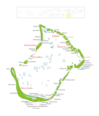
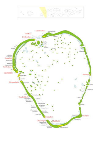
Raa Atoll is an administrative division from the Maldives. The capital is Ungoofaaru. It includes Northern Maalhosmadulu Atoll proper and the island of Alifushi.

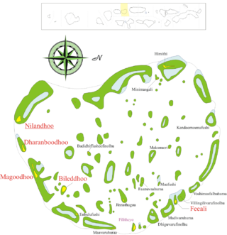
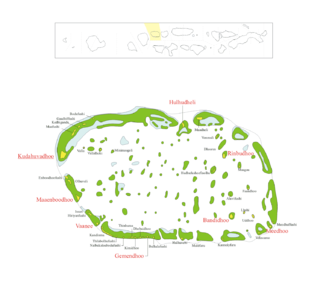
Baa Atoll is an administrative division of the Maldives. It consists of three separate natural atolls, namely southern Maalhosmadulu Atoll, the Fasdūtherē Atoll and the smaller natural atoll known as Goifulhafehendhu Atoll.
Lhaviyani Atoll is an administrative division of the Maldives. Its abbreviation is Lh.

Alif Alif Atoll is an administrative division of the Maldives. It was created on March 1, 1984, combining northern section of Ari Atoll, the small Rasdhukuramathi Atoll, and the isolated island of Thoddoo. Many of the islands in this atoll have been inhabited since ancient times and have archaeological remains from the Maldivian Buddhist period.

Alifu Dhaalu Atoll is an administrative division of the Maldives.
Vaavu Atoll is an administrative division of the Maldives, comprising the natural atolls of Felidhu Atoll and the Vattaru Reef.

Mulaku Atoll or Meemu Atoll(މުލަކަތޮޅު) is an administrative division of the Maldives. It corresponds to the natural atoll of the same name, also known as Mulak Atoll or 'Mulakatolhu'.
Dhaalu Atoll is one of the atolls of the Maldives. It corresponds to the natural atoll of the same name.
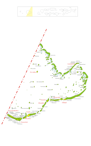
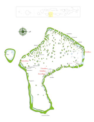
Gaafu Alifu is an administrative division of the Maldives created on February 8, 1962, when Huvadhu Atoll was divided into two districts. Gaafu Alifu corresponds to the northeastern section of this large natural atoll north of the line extending between the channels of Footukandu and Vaarulu Kandu. The capital of this district is Vilingili.

Gaafu Dhaalu is an administrative district of the Maldives formed by the southwestern section of Huvadhu Atoll. It was created on February 8, 1962, when Huvadhu Atoll was divided into two districts. Gaafu Dhaalu corresponds to the Southwestern section of this large natural atoll, south of the line extending between the channels of Footukandu and Vaarulu Kandu. The capital of this region is Thinadhoo. There are 153 islands in this district, 10 of which are inhabited. This district is located about 340 kilometers south of the capital Malé.

Ari Atoll is one of the natural atolls of the Maldives. It is one of the biggest atolls and is located in the west of the archipelago. The almost rectangular alignment spreads the islands over an area of about 89 by 3 kilometres. It has been divided in two sections for administrative purposes, Northern Ari Atoll and Southern Ari Atoll consisting of 105 islands. Ari Atoll is part of the zone designated for tourist development in the Maldives. It is roughly a 30-minute seaplane flight away from the Capital Malé.
Northern Maalhosmadulu Atoll is an atoll from the Maldives. It includes Northern Maalhosmadulu Atoll proper and the island of Alifushi.
Kolhumadulu Atoll is an administrative division of the Maldives. It corresponds to the natural atoll of the same name. The ancient name of the island was Kolhumaduva during the time of King Koimala who united all atolls of the Maldives under one kingdom for the first time.

Haa Alif Atoll is the code name based on the letters of the Maldivian alphabet commonly used to refer to the administrative division officially known as North Thiladhunmathi Atoll in the Maldives.

The Human Rights Measurement Initiative finds that Maldives is fulfilling 72.0% of what it should be fulfilling for the right to health based on its level of income. When looking at the right to health with respect to children, Maldives achieves 98.0% of what is expected based on its current income. In regards to the right to health amongst the adult population, the country achieves 99.7% of what is expected based on the nation's level of income. Maldives falls into the "very bad" category when evaluating the right to reproductive health because the nation is fulfilling only 18.2% of what the nation is expected to achieve based on the resources (income) it has available.
References
- ↑ Dhivehi Thaareekh- Heroic Warriors and Lazy Kings, 1759-1827, National Centre of Linguistics and Historical Research, Male', Maldives, 1981
7°05′35″N72°52′42″E / 7.09306°N 72.87833°E
| | This Maldives location article is a stub. You can help Wikipedia by expanding it. |