
Pago Pago is the capital of American Samoa. It is in Maoputasi County on Tutuila, the main island of American Samoa.

Tutuila is the largest and most populous island of American Samoa and is part of the archipelago of the Samoan Islands. It is the third largest island in the Samoan Islands chain of the Central Pacific. It is located roughly 4,000 kilometers (2,500 mi) northeast of Brisbane, Australia and lies over 1,200 kilometers (750 mi) to the northeast of Fiji. It contains a large, natural harbor, Pago Pago Harbor, where Pago Pago, the capital of American Samoa, is situated. Pago Pago International Airport is also located on Tutuila. The island's land expanse is about 68% of the total land area of American Samoa. With 56,000 inhabitants, it is also home to 95% of the population of American Samoa. The island has six terrestrial and three marine ecosystems.

Fagatogo is the downtown area of Pago Pago. Located in the low grounds at the foot of Matafao Peak, it was the location of the first American settlement on Tutuila Island. It includes the sub-village of Malaloa. Today, Fagatogo is the government, commercial, financial, and shipping center of Tutuila. It is also the administrative capital of American Samoa. It is the location of the American Samoa Fono (legislature), and is listed in the Constitution of American Samoa as the territory's official seat of government. Its population is 1,737.
Utulei or ʻUtulei is a village in Maoputasi County, in the Eastern District of Tutuila, the main island of American Samoa. Utulei is traditionally considered to be a section of Fagatogo village, the legislative capital of American Samoa, and is located on the southwest edge of Pago Pago Harbor. Utulei is the site of many local landmarks: The A. P. Lutali Executive Office Building, which is next to the Feleti Barstow Library; paved roads that wind up to a former cablecar terminal on Solo Hill; the governor's mansion, which sits on Mauga o Alii, overlooking the entrance to Goat's Island, and the lieutenant governor's residence directly downhill from it; the Lee Auditorium, built in 1962; American Samoa's television studios, known as the Michael J. Kirwan Educational Television Center; and the Rainmaker Hotel. Utulei Terminal offers views of Rainmaker Mountain.

Rainmaker Mountain is the name of a mountain located near Pago Pago, American Samoa on Tutuila Island. Rainmaker Mountain traps rain clouds and gives Pago Pago the highest annual rainfall of any harbor. The average annual rainfall on the mountain is around 200 inches (510 cm). It has a three-pronged summit. Rainmaker Mountain and its base were designated a National Natural Landmark in 1972 due to the slopes’ tropical vegetation.
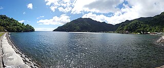
Aūa is a village on Tutuila Island in American Samoa. It is located along American Samoa Highway 001, and is the southern terminus of American Samoa Highway 006. Aūa is located at the foothills of Mount Peiva on the eastern shore of Pago Pago Bay. The hamlet of Leloaloa is also a part of Aūa.
American Samoa Department of Education (ASDOE) operates public schools in American Samoa, an insular area of the United States. American Samoa contains 23 primary schools, 10 secondary schools, and the remaining 5 are either administered by religious denominations or privately owned.

Afono is a village on the northeast coast of Tutuila Island, American Samoa. One of the island's more populous villages, it is located on the edge of Afono Bay, at the eastern edge of the National Park of American Samoa. It is connected by Highway 6 to Vatia, which lies along the coast to the northwest, and to Aua, on the edge of Pago Pago Harbor to the south via a winding stretch of highway which crosses the spine of the island.
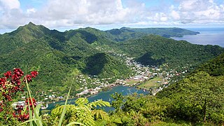
Pago Pago Harbor on Tutuila Island in American Samoa is one of the world's largest natural harbors. The capital, Pago Pago is located on the inner reaches of the harbor, close to its northwesternmost point. It has the highest annual rainfall of any harbor in the world. It is also considered one of the best and deepest deepwater harbors in the South Pacific Ocean or in Oceania as a whole. Pago Pago Bay is over 400 feet (120 m) deep and two miles (3.2 km) long. As part of the Pago Volcano caldera, the harbor is 50% landlocked.
Fagaʻalu is a village in central Tutuila Island, American Samoa. It is also known as Fagaʻalo. It is located on the eastern shore of Pago Pago Harbor, to the south of Pago Pago. American Samoa's lone hospital, Lyndon B. Johnson Tropical Medical Center, is located in Fagaʻalu. The village is centered around Fagaalu Stream.
Faleniu is a village in the west of Tutuila Island, American Samoa. It is located inland from the village of Tafuna, in Tuālāuta County.

Archaeology of Samoa began with the first systematic survey of archaeological remains on Savai'i island by Jack Golson in 1957. Since then, surveys and studies in the rest of Samoa have uncovered major findings of settlements, stone and earth mounds including star mounds, Lapita pottery remains and pre-historic artifacts.

Matafao Peak is a mountain in American Samoa, on the island of Tutuila. With an elevation of 653 metres (2,142 ft), it is the highest peak on Tutuila Island. The mountain, like Rainmaker Mountain across Pago Pago Harbor, is a remnant of a volcanic plug and is part of the volcanic origins of the island. The mountain can be hiked from the high point of the Pago Pago-to-Fagasa Road. It is designated a National Natural Landmark above the 492-foot (150 m) level, an area known as Matafao Peak National Natural Landmark.

Vatia is a village on Tutuila Island in American Samoa. It is a north shore village located on Vatia Bay. The road to Vatia, American Samoa Highway 006, is the only road going through National Park of American Samoa. Vatia is a scenic community at the foot of Pola Ridge and surrounded by the national park. It is only reached by Route 6 which traverses the national park before reaching Vatia. There was once a hiking trail over Maugaloa Ridge from Leloaloa, but since the completion of Route 6, this trail is now overgrown. It is home to a beach, and panoramic views of jungle-covered peaks surround the village on all sides. Vatia is the center of the Tutuila-section of National Park of American Samoa. It is located in Vaifanua County.
Maʻopūtasi County is located in the Eastern District of Tutuila Island in American Samoa. Maʻopūtasi County comprises the capital of Pago Pago and its harbor, as well as surrounding villages. It was home to 11,695 residents as of 2000. Maʻopūtasi County is 6.69 square miles (17.3 km2) The county has a 7.42-mile (11.94 km) shoreline which includes Pago Pago Bay.
Fagatogo Market is a market centred in the Fagatogo area of Pago Pago, the capital of American Samoa. It opened in 2010 for farmers and fishermen to sell fruits, vegetables and fish. Souvenirs are sold among live entertainment here when cruise ships are in town. It lies in front of Pago Pago's main bus terminal. Nearby are Fagatogo Square Shopping Mall. Mount 'Alava, the canneries in Atu'u, Rainmaker Mountain and Pago Pago Harbor.
Fagasā is a village in the Eastern District of Tutuila Island in American Samoa. The village lies by Fagasa Bay, on the north shore of the island. Its name is Samoan and translates to "Forbidden Bay." The village borders the Tutuila-section of National Park of American Samoa.

Itūʻau County is a county in the Eastern District in American Samoa. The official name is Itūʻau ma Nofo, however, it is commonly known as just Itūʻau. It is divided into northern and southern parts by the highest part of the Tutuila's central mountain range. It is peculiar in that it had no county chief. In Nuʻuuli in the south, power was divided between village high chief Savusa and the Four Chiefly Houses of the Soliai, Tago, Levu, and Alega. In Fagasā in the north, leadership was shared by the Tupuola and the Alo. The physical division of the county by mountains combined with the lack of a high chief made the county a battleground (itu'au) in ancient times.
Mount ʻAlava is the second-highest mountain on Tutuila Island in American Sāmoa. Its summit has an elevation of 491 meters. The summit of the mountain can be reached via the Mount Alava Trail. Also known by the name Mount Alava Adventure Trail, this steep route features 56 ladders and 783 steps. A broadcast station was established on Mount Alava in 1964.

Mount Tepatasi is a 203-meter (666-foot) mountain situated near Happy Valley in Pago Pago, the capital of American Sāmoa. It is part of the mountainous terrain that surrounds and protects Pago Pago Harbor, one of the most notable natural harbors in the Pacific. The village of Pago Pago is nestled amidst a range of tall peaks, including Mount Tepatasi and other prominent mountains such as Mount Matafao, Rainmaker Mountain, Mount ʻAlava, Mount Siona, and Mount Matai.
