
The Triangle Link is a fixed link with three branches that connects the islands of Stord and Bømlo to each other and to the mainland at Sveio, Norway. It consists of the underwater Bømlafjord Tunnel from Sveio to the island of Føyno, the Stord Bridge from there to Stord, and a road including the Bømla Bridge and the Spissøy Bridge to Bømlo. The section from Sveio to Stord is part of European Route E39, while the branch to Bømlo is part of County Road 542.
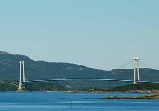
The Stord Bridge is a suspension bridge which crosses Digernessundet between the islands of Stord and Føyno in Stord, Norway. The bridge is 1,077 meters (3,533 ft) long, has a main span of 677 meters (2,221 ft) and a clearance below of 18 meters (59 ft). It carries two lanes of European Route E39 and a combined pedestrian and bicycle pathway. It is part of the Triangle Link, a fixed link which connects Stord to Bømlo, and both to the mainland. In 2010, the bridge had an average 5,021 vehicles per day. The bridge and the link was a toll road from the opening until 30 May 2013.
The Bømla Bridge is a suspension bridge which crosses Spissøysundet between the islands of Nautøy in Stord and Spissøy in Bømlo, Norway. The bridge is 998 meters (3,274 ft) long, has a main span of 577 meters (1,893 ft) and a clearance below of 36 meters (118 ft). It carries two lanes of County Road 542 and a combined pedestrian and bicycle pathway. It is part of the Triangle Link, a fixed link which connects Stord to Bømlo, and both to the mainland at Sveio. Plans for a crossing arose in the 1960s, and was until the 1990s planned as a pontoon bridge further north. The Bømla Bridge entered the plans after the decision to combine the crossing with the Bømlafjord Tunnel. Construction started in 1999; the bridge cost 342 million Norwegian krone (NOK) and was opened for use on 30 April 2001. The bridge is a toll road.
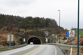
The Bømlafjord Tunnel is a subsea road tunnel under Bømlafjorden which connects the island of Føyno in Stord to the mainland at Dalshovda in Sveio, Norway. The tunnel is 7.82 kilometers (4.86 mi) long and reaches 260.4 m (854 ft) below mean sea level. It carries three lanes of European Road E39 and is part of the Triangle Link, a fixed link which connects Sunnhordland to Haugaland. Plans for the tunnel arose in the 1980s; construction started in 1997 and the tunnel opened on 27 December 2000. The tunnel was built using the drilling and blasting method, with two teams building from each end. The tunnel runs through an area composed mostly of gneiss, phyllite and greenstone. The tunnel is the longest subsea tunnel in Norway and was the second-deepest in the world until 2008. It is still (2013) the deepest point on the E-road network. The tunnel was a toll road from the opening until 30 April 2013. In 2012 the tunnel had an average 4,084 vehicles per day.
Vigdarvatnet is a lake in the municipality of Sveio in Hordaland county, Norway. A small arm off the main lake juts to the south and runs along the municipal-county border between Sveio in Hordaland county and the town of Haugesund in Rogaland county. The 10-kilometre (6.2 mi) long lake forms a U-shape. It is fed by the nearby lake Stakkastadvatnet to the south, and it empties into the Ålfjorden, a small fjord arm off the main Hardangerfjorden. The village of Sveio lies on the northwestern shore of the lake.
Valestrand is a former municipality in Hordaland county, Norway. The 59-square-kilometre (23 sq mi) municipality was located on a peninsula on the southern shore of the Bømlafjorden inside the present-day municipality of Sveio. The administrative centre of Valestrand was the village of Valevåg. The two churches in Valestrand were Valen Chapel and Valestrand Church.
Langevåg is a village in Bømlo municipality in Hordaland county, Norway. It is located on the southern tip of the island of Bømlo, along the Bømlafjorden. It lies in the far southern part of the municipality, about 12 kilometres (7.5 mi) south of the village of Lykling. The 1.15-square-kilometre (280-acre) village has a population (2013) of 796, giving the village a population density of 692 inhabitants per square kilometre (1,790/sq mi). This makes it the fourth largest village in the municipality.
Nils Andreas Økland was a Norwegian Esperantist and teacher in Stord (Hordaland), Norway. He spent some years in his youth on the island Utsira, where his father was a school teacher. Nils Økland was married to Hanna Olava Bergstøl, and they had 3 sons. His father Matthias Larsen Økland was also a school teacher and a church chorister; his mother was Signi Nilsdatter from Eidsvåg. Having learned Esperanto indirectly through his friend Haldor Midthus by 1904, he served as president on the executive council of Stord's Norwegian Esperanto League branch.

Føyno is an island in Stord municipality in Hordaland county, Norway. The 1-square-kilometre (0.39 sq mi) island lies southwest of the island of Stord at the southern end of the Stokksundet sound. The Digernessundet strait runs between Stord and this island. Føyno had a central place in the district of Sunnhordland during the Middle Ages, and gave its name to the skipreide of Føyen.

Auklandshamn or Økland is a village in Sveio municipality in Hordaland county, Norway. The village is located in the northern part of the traditional district of Haugaland, along the southern shore of the Bømlafjorden. Historically, the area was part of the municipality of Finnås, but it was transferred to the municipality of Valestrand in 1870. In 1964, it was transferred to the municipality of Sveio.
Våga is a small village in Sveio municipality in Hordaland county, Norway. The village is located on the east side of Viksefjorden, along the county border with Rogaland. Norwegian County Road 47 runs through the village, connecting it to the town of Haugesund about 10 kilometres (6.2 mi) to the south and to the village of Sveio, located about 8 kilometres (5.0 mi) to the north.

Skjersholmane–Valevåg Ferry was an automobile ferry which connected the island of Stord to the mainland in Sveio. The route was operated by Hardanger Sunnhordlandske Dampskipsselskap (HSD) and ran between Skjersholmane on Stord to Valevåg on the mainland as part of European Route E39. In 2000 the ferry transported 480,103 vehicles and 1,069,446 passengers.

Mosterhamn or simply Moster is a village in Bømlo municipality in Hordaland county, Norway. The village is located on the small island of Moster in the southeastern part of the municipality of Bømlo. The village lies along the Bømlafjorden. The 1.75-square-kilometre (430-acre) village has a population (2013) of 1,354; giving the village a population density of 774 inhabitants per square kilometre (2,000/sq mi) and making it the second largest urban area in the municipality.
Sveio is the administrative centre of Sveio municipality in Hordaland county, Norway. The village is located on the northwestern shore of the lake Vigdarvatnet, about half-way between the villages of Våga and Førde. The 0.88-square-kilometre (220-acre) village has a population (2013) of 1336, giving the village a population density of 1,518 inhabitants per square kilometre (3,930/sq mi). The village lies along Norwegian County Road 47. Sveio Church is located here. The newspaper Vestavind has been published in Sveio since 1986.

Sveio Church is a parish church in Sveio municipality in Hordaland county, Norway. It is located in the village of Sveio. The church is part of the Sveio parish in the Sunnhordland deanery in the Diocese of Bjørgvin.

Førde Church is a parish church in Sveio municipality in Hordaland county, Norway. It is located in the village of Førde. The church is part of the Valestrand og Førde parish in the Sunnhordland deanery in the Diocese of Bjørgvin.
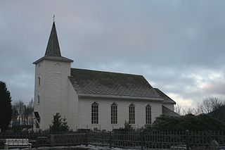
Valestrand Church is a parish church in Sveio municipality in Hordaland county, Norway. It is located in the village of Valestrand, just south of the village of Valevåg. The church is part of the Valestrand og Førde parish in the Sunnhordland deanery in the Diocese of Bjørgvin. The white, wooden church was built in 1873 by the architect Ole Vangberg. The church, which seats about 400 people, was consecrated on 15 October 1873 by the Bishop Peter Hersleb Graah Birkeland. The church here was originally built to replace the small nearby Valen Church, which was renovated and turned into a school.

Valen Chapel is a parish church in Sveio municipality in Hordaland county, Norway. It is located in the village of Valevåg. The church is part of the Valestrand og Førde parish in the Sunnhordland deanery in the Diocese of Bjørgvin.


