
The Arctic Archipelago, also known as the Canadian Arctic Archipelago, is an archipelago lying to the north of the Canadian continental mainland, excluding Greenland and Iceland.

Asientos is a municipality in the Mexican state of Aguascalientes. It stands at 22°14′N102°05′W. The town of Real de Asientos serves as the municipal seat for the surrounding municipality of Asientos.

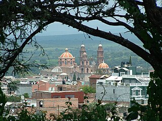
Tecalitlán is a town and municipality in the central Pacific coastal state of Jalisco, Mexico. Located just south of Ciudad Guzmán, the population of the municipality was 16,705 as of 2020.

The Roman Catholic Archdiocese of Guadalajara is a Roman Catholic archdiocese based in the Mexican city of Guadalajara, Jalisco. It currently covers an area of 20,827 km². The diocese was erected on July 13, 1548 and was elevated to Archdiocese on January 26, 1863.

El Camino Real de Tierra Adentro, also known as the Silver Route, was a Spanish 2,560-kilometre-long (1,590 mi) road between Mexico City and San Juan Pueblo, New Mexico, that was used from 1598 to 1882. It was the northernmost of the four major "royal roads" that linked Mexico City to its major tributaries during and after the Spanish colonial era.

Arandas is a municipality of the Altos Sur region of the state of Jalisco in Mexico. Arandas is also the name of the municipality's main township and the center of the municipal government. The city centre is located approximately 86 miles (138 km) east of Guadalajara, the state capital. Arandas is accessible to residents of Guadalajara by the Mexican Federal Highway 80D and Jalisco State Highway 314.
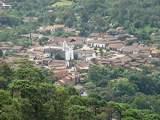
San Sebastián del Oeste is a town and municipality, located on the western part of Jalisco state, Mexico, between 20°39’45’’ - 21°02’30’’ N and 104°35’00’’ - 104°51’00’’ W, at a height of 1,480 metres (4,856 ft).
Los Ramones is the name of a municipality and its corresponding seat of government and main population center in Mexican state of Nuevo Leon.
Valle de Guadalupe may refer to:
Valle de Guadalupe is a village in Michoacán, Mexico.
Valle de Guadalupe is a village in Querétaro, Mexico. It is located in the municipality of Landa de Matamoros. It has 834 inhabitants, and is located at 1620 meters above sea level.

Villa Hidalgo is a municipality in the state of Jalisco in Mexico.

Mazamitla is a town and municipality of the Mexican state of Jalisco. It is located 124 km south of Guadalajara in the Southeast Region and is a popular resort destination for travelers from Guadalajara and nearby urban centers. Its name comes from the Nahuatl and means "place where arrows are made to hunt deer"; its area is 288.9 km2. According to Count II Population and Housing, the municipality has 11671 inhabitants who are devoted mainly to the tertiary sector. For its natural environment is considered by the federal Secretariat of Tourism as a Pueblo Mágico.
Teocaltiche is a town and municipality in the central-western Mexican state of Jalisco. It is located in the northeastern highlands region of Jalisco, commonly referred to in Spanish as "Los Altos de Jalisco". The grasshopper or "chapulin" is a popular icon for the town.
Cañadas de Obregón is a town and municipality, in Jalisco in central-western Mexico. It is located in the Altos Sur Region. The municipality covers an area of 182.09 square miles (271.8 km2).

San Miguel el Alto is a town and municipality, in Jalisco in central-western Mexico. The municipality covers an area of 787 km2.
Las Minas Creek is one of the main tributaries of the San Martín River in southwestern San Martín de Hidalgo municipality in the Mexican state of Jalisco.
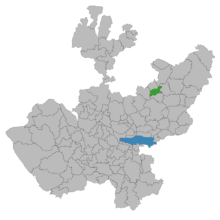
San Ignacio Cerro Gordo is a municipality in Jalisco, Mexico. It was established by the Congress of the State of Jalisco, on 1 January 2007 out of Arandas. Decree Number 20371 was published in the Periódico Oficial El Estado de Jalisco, on 30 December 2003, three years before the creation of this municipality, to allow its municipal authorities to be elected by the citizens in the election of municipal presidents on 2 July 2006.

The Altos de Jalisco, or the Jaliscan Highlands, is a geographic and cultural region in the eastern part of the Mexican state of Jalisco, famed as a bastion of Mexican culture, cradling traditions from Tequila production to Charrería equestrianism. Los Altos are part of the greater Bajío region of Mexico.

The Cathedral Basilica of Our Lady of St. John of the Lakes also called San Juan de los Lagos Cathedral It is a Catholic church located in the city of San Juan de los Lagos, in the state of Jalisco, Mexico, headquarters of the diocese of San Juan de los Lagos. This Cathedral-Basilica ranks second in the number of visitors in the country after the Basilica of Our Lady of Guadalupe.