
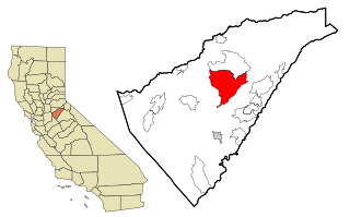
Calaveras County, officially the County of Calaveras, is a county in both the Gold Country and High Sierra regions of the U.S. state of California. As of the 2020 census, the population was 45,292. The county seat is San Andreas. Angels Camp is the county's only incorporated city. Calaveras is Spanish for "skulls"; the county was reportedly named for the remains of Native Americans discovered by the Spanish explorer Captain Gabriel Moraga.

Angels Camp, also known as City of Angels and formerly Angel's Camp, Angels, Angels City, Carson's Creek and Clearlake, is the only incorporated city in Calaveras County, California, United States. The population was 3,836 at the 2010 census, up from 3,004 at the 2000 census. It lies at an elevation of 1378 feet.
Mokelumne Hill is a census-designated place (CDP) in Calaveras County, California, United States. The population was 646 at the 2010 census, down from 774 at the 2000 census. It is commonly referred to as "Moke Hill" by locals. The town takes its name from the neighboring Mokelumne River, which in turn is Miwok for the "people of Mokel," the likely name of a Native American village in the area.
Mountain Ranch is a census-designated place (CDP) in Calaveras County, California, United States. The population was 1,628 at the 2010 census, up from 1,557 at the 2000 census. The town is registered as California Historical Landmark #282. The town center is quite small with fewer than 50 people living in it. The 5 mile square area surrounding the town accounts for the balance of the population.
Murphys, originally Murphys New Diggings then Murphy's Camp, is an unincorporated village located in the foothills of the Sierra Nevada mountains in Calaveras County, California, United States. The population was 2,213 at the 2010 census, up from 2,061 at the 2000 census.
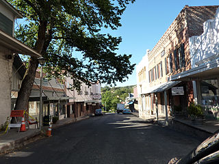
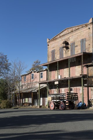
San Andreas is an unincorporated census-designated place and the county seat of Calaveras County, California. The population was 2,783 at the 2010 census, up from 2,615 at the 2000 census. Like most towns in the region, it was founded during the California Gold Rush. The town is located on State Route 49 and is registered as California Historical Landmark #252.

Vallecito is a census-designated place (CDP) in Calaveras County, California, United States. The population was 442 at the 2010 census, up from 427 at the 2000 census. The town is registered as California Historical Landmark #273. Nearby is Moaning Cavern, the largest cave chamber in California, which the Miwok Indians used as a burial ground.

Placerville is a city in and the county seat of El Dorado County, California. The population was 10,747 as of the 2020 census, up from 10,389 as of the 2010 census. It is part of the Sacramento–Arden-Arcade–Roseville Metropolitan Statistical Area.

State Route 49 is a north–south state highway in the U.S. state of California that passes through many historic mining communities of the 1849 California gold rush and it is known as the Golden Chain Highway. The highway's creation was lobbied by the Mother Lode Highway Association, a group of locals and historians seeking a single highway to connect many relevant locations along the Gold Rush to honor the 49ers. One of the bridges along SR 49 is named for the leader of the association, Archie Stevenot.
Archie Stevenot was a prominent citizen in Calaveras County, California and Supreme Noble Grand Humbug of E Clampus Vitus. Born in Carson Hill, Stevenot helped found the California Chamber of Commerce and his family established the borax industry in the state. He also established the Mother Lode Highway Association in 1919 which was primarily responsible for the creation of State Route 49. As a result, the bridge across the Stanislaus River between Tuolumne and Calaveras counties on SR 49 is named the Archie Stevenot Bridge in his honor, and his birthplace has been declared a California Historical Landmark No. 769.

Marshall Gold Discovery State Historic Park is a state park of California, United States, marking the discovery of gold by James W. Marshall at Sutter's Mill in 1848, sparking the California Gold Rush. The park grounds include much of the historic town of Coloma, California, which is now considered a ghost town as well as a National Historic Landmark District. The park contains thre California Historical Landmarks: a monument to commemorate James Marshall (#143), the actual spot where he first discovered gold in 1848 (#530). Established in 1942, and Coloma Road (#748),. The park now comprises 576 acres (233 ha) in El Dorado County.
You Bet is a small unincorporated community in Nevada County, California. You Bet is located in the Sierra Nevada foothills, 7 miles (11.3 km) east of Grass Valley and 5.5 miles (8.9 km) northeast of Chicago Park.

Twisted Oak Winery is a family-owned boutique winery in Vallecito, California specializing in wine made from grape varieties native to the Mediterranean regions of western Europe. The winery is located on a hilltop at 2280 ft above sea level in the foothills of the Sierra Nevada Mountains, and most of the grapes for the wines are sourced from nearby vineyards in Calaveras County. The winery name and logo design are derived from a California Blue Oak tree on the property.
Gold Hill in Grass Valley, California, was the site of one of the first discoveries of quartz gold in California. While quartz gold was also found in other areas of Nevada County, California during the same time, it is this find near Wolf Creek that led to quartz-mining frenzy and subsequent creation of the Gold Country quartz-mining industry. The location is honored as a California Historical Landmark.
The Encino Oak Tree, also known as the Lang Oak, was a 1,000-year-old California live oak tree, Quercus agrifolia, in the Encino section of Los Angeles, California. It was designated as a Los Angeles Historic-Cultural Monument in 1963.
List table of the properties and districts — listed on the California Historical Landmarks — within Calaveras County, California.

The Big Bar, also called Upper Bar, is a gold mine in Jackson, California, United States. The mine opened in 1848 along the Mokelumne River and is registered as California Historical Landmark #41.
The site of the Old Mining Camp of Brownsville is a California Historical Landmark on Pennsylvania Gulch Road east of the town of Murphys, California in Calaveras County. The Mining Camp of Brownsville was a California Gold Rush camp in Pennsylvania Gulch in from 1850 to 1870. The camp is named after Alfred Brown, who was the former owner of the Table Mountain Ranch. There were many rich mines in the area and Brownsville Mining Camp supported this activity. So rich was the area, the Brownsville Mining District limited the size of mines in the District. Each miner could claim and own only one wet and one dry site, no larger than 150 square feet each. Brownsville Mining District was in the area of Pennsylvania Gulches and Missouri Gulches 2 miles from Murphys. There are no remains of the camp, but nearby is the Brownsville Mining District Cemetery. A plaque monument was dedicated on July 19, 1953, by California State Park Commission with the monument base built by Christa Parlor No. 137 and Ruby Parlor No. 49 of the Native Daughters of the Golden West.
Peter L. Traver Building is a historical building in Murphys, California in Calaveras County. The building was built by Peter L. Traver in 1856. The building is the oldest stone building in Murphys. Being made of stone, built with iron shutters and Peter L. Traver Building placing sand on the roof protected the building from the town's many fires. Fire swept through the town in 1859, 1874, and 1893. Peter L. Traver was a gold Rush miner who opened a general store in the building. Traver sold the building to the Manuel Estate Company in 1883. Over the years the building has been a general store, warehouse, a Wells Fargo office, and auto repair garage. From age and lack of repairs, the building was set to be taken down in 1949. Dr. Coke Wood and his wife Ethelyn after hearing this, purchased and restored the building. The descendants of the Woods family have turned the Peter L. Traver Building into the Murphys Old Timers Museum. In 2016 the Museum became a community museum, run by volunteers and supported by donations and gift shop sales. Many in the community have donated artifacts to the Museum about Murphys' gold-rush history. The Peter L. Traver Building is a California Historical Landmark No. 266.


