
The Alps are the highest and most extensive mountain range system that lies entirely in Europe, and stretch approximately 1,200 kilometres (750 mi) across eight Alpine countries : France, Switzerland, Monaco, Italy, Liechtenstein, Austria, Germany, and Slovenia. The Alpine arch generally extends from Nice on the western Mediterranean to Trieste on the Adriatic and Vienna at the beginning of the Pannonian basin. The mountains were formed over tens of millions of years as the African and Eurasian tectonic plates collided. Extreme shortening caused by the event resulted in marine sedimentary rocks rising by thrusting and folding into high mountain peaks such as Mont Blanc and the Matterhorn. Mont Blanc spans the French–Italian border, and at 4,809 m (15,778 ft) is the highest mountain in the Alps. The Alpine region area contains about a hundred peaks higher than 4,000 metres (13,000 ft).

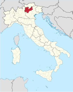
Piedmont is a region in northwest Italy, one of the 20 regions of the country. It borders the Liguria region to the south, the Lombardy and Emilia-Romagna regions to the east and the Aosta Valley region to the northwest; it also borders Switzerland to the northeast and France to the west. It has an area of 25,402 square kilometres (9,808 sq mi) making it the second largest region of Italy after Sicily and a population of 4,377,941 as of 30 November 2017. The capital of Piedmont is Turin.

Ladin is a Romance language of the Rhaeto-Romance subgroup, mainly spoken in the Dolomite Mountains in Northern Italy in the provinces of South Tyrol, Trentino, and Belluno, by the Ladin people. It exhibits similarities to Swiss Romansh and Friulian.

Umbria is a region of central Italy. It includes Lake Trasimeno and Marmore Falls, and is crossed by the River Tiber. The regional capital is Perugia.

The Cottian Alps ; are a mountain range in the southwestern part of the Alps. They form the border between France and Italy (Piedmont). The Fréjus Road Tunnel and Fréjus Rail Tunnel between Modane and Susa are important transportation arteries between France and Italy (Turin).

South Tyrol is an autonomous province in northern Italy, one of the two that make up the autonomous region of Trentino-Alto Adige/Südtirol. Its official trilingual denomination is Autonome Provinz Bozen – Südtirol in German, Provincia autonoma di Bolzano – Alto Adige in Italian and Provinzia autonoma de Bulsan – Südtirol in Ladin, reflecting the three main language groups to which its population belongs. The province is the northernmost of Italy, the second largest, with an area of 7,400 square kilometres (2,857 sq mi) and has a total population of 531,178 inhabitants as of 2019. Its capital and largest city is Bolzano.

The canton of (the) Grisons, or canton of Graubünden, is the largest and easternmost canton of Switzerland. It has international borders with Italy, Austria, and Liechtenstein. Its German name, Graubünden, translates as the "Grey Leagues", referring to the canton's origin in three local alliances, the League of God's House, the Grey League, and the League of the Ten Jurisdictions. Grisons is the only officially trilingual canton and the only one where the Romansh language has official status. Swiss German, Italian, and Romansh are all native to the canton. The Romansh name of the canton, Grischun, translates literally as the "Big Grey", while La Grischa translates as "The Grey", referring to the Grey League.

The Apennines or Apennine Mountains are a mountain range consisting of parallel smaller chains extending c. 1,200 km (750 mi) along the length of peninsular Italy. In the northwest they join with the Ligurian Alps at Altare. In the southwest they end at Reggio di Calabria, the coastal city at the tip of the peninsula. Since 2000 the Environment Ministry of Italy, following the recommendations of the Apennines Park of Europe Project, has been defining the Apennines System to include the mountains of north Sicily, for a total distance of 1,500 kilometres (930 mi). The system forms an arc enclosing the east side of the Ligurian and Tyrrhenian Seas.

The regions of Italy are the first-level constituent entities of the Italian Republic, constituting its second NUTS administrative level. There are 20 regions, of which five have a broader amount of autonomy than the other 15 regions. Under the Italian Constitution, each region is an autonomous entity with defined powers. With the exception of the Aosta Valley, each region is divided into a number of provinces.
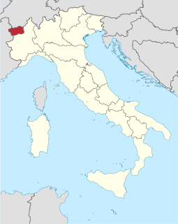
The Aosta Valley is a mountainous autonomous region in northwestern Italy. It is bordered by Auvergne-Rhône-Alpes, France, to the west, Valais, Switzerland, to the north and by Piedmont, Italy, to the south and east. The regional capital is Aosta.

Franco-Provençal is a dialect group within Gallo-Romance spoken in east-central France, western Switzerland, northwestern Italy, and in enclaves in the Province of Foggia in Apulia, Italy.

The Province of Bergamo is a province in the Lombardy region of Italy. It has a population of 1,112,187 (2017), an area of 2,754.91 square kilometers (1,063.68 sq mi), and contains 243 comuni. Its capital is the city of Bergamo.

Nave is a town and comune in the province of Brescia, in Lombardy, Italy. Neighbouring communes are, from the south and clockwise: Brescia, Bovezzo, Concesio, Lumezzane, Caino, Serle and Botticino. It is located in the Garza valley.
Trentino, officially the Autonomous Province of Trento, is an autonomous province of Italy, in the country's far north. The Trentino and South Tyrol constitute the region of Trentino-Alto Adige/Südtirol, an autonomous region under the constitution. The province is composed of 177 comuni (municipalities). Its capital is the city of Trento. The province covers an area of more than 6,000 km2 (2,300 sq mi), with a total population of 541,098 in 2019. Trentino is renowned for its mountains, such as the Dolomites, which are part of the Alps.

Monte Rosa is a mountain massif located in the eastern part of the Pennine Alps. It is located between Italy and Switzerland (Valais). Monte Rosa is the second highest mountain in the Alps and western Europe, after Mont Blanc.
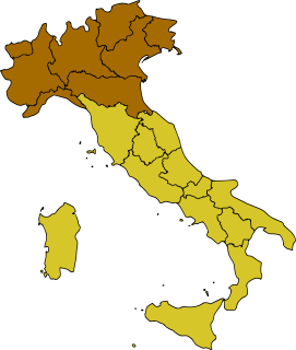
Northern Italy is a geographical and cultural region in the northern part of Italy. Non-administrative, it consists of eight administrative Regions in northern Italy: Aosta Valley, Piedmont, Liguria, Lombardy, Emilia-Romagna, Veneto, Friuli-Venezia Giulia and Trentino-Alto Adige/Südtirol. As of 2014, its population was 27,801,460. Rhaeto-Romance and Gallo-Italic languages are spoken in the region, as opposed to the Italo-Dalmatian languages spoken in the rest of Italy. The Venetian language is sometimes considered to be part of the Italo-Dalmatian languages, but some major publications such as Ethnologue and Glottolog define it as Gallo-Italic.
Resia is a comune (municipality) in the Province of Udine, in the Friuli-Venezia Giulia region of northern Italy, bordering on the municipalities of Chiusaforte, Lusevera, Resiutta, and Venzone, and also on two of the Slovenian municipalities. Its residents speak an archaic dialect known as Resian, which is - according to most linguists - a transitional dialect between the Carinthian and Littoral dialects of Slovene language. Although they maintain their own traditional system of family names, which are of Slavic origin, the people of Resia have either Italian or Italianized surnames, similarly to some areas in Venetian Slovenia.

The Po Valley, Po Plain, Plain of the Po, or Padan Plain is a major geographical feature of Northern Italy. It extends approximately 650 km (400 mi) in an east-west direction, with an area of 46,000 km2 including its Venetic extension not actually related to the Po river basin; it runs from the Western Alps to the Adriatic Sea. The flatlands of Veneto and Friuli are often considered apart since they do not drain into the Po, but they effectively combine into an unbroken plain.

The Raeti were a confederation of Alpine tribes, whose language and culture may have been related to those of Etruscans. From not later than ca. 500 BC, they inhabited the central parts of present-day Switzerland, Tyrol in Austria, the Alpine regions of northeastern Italy and Germany south of the Danube.

The Po is the longest river in Italy. It is a river that flows eastward across northern Italy starting from the Cottian Alps. The Po flows either 652 km (405 mi) or 682 km (424 mi) – considering the length of the Maira, a right bank tributary. The headwaters of the Po are a spring seeping from a stony hillside at Pian del Re, a flat place at the head of the Val Po under the northwest face of Monviso. The Po then extends along the 45th parallel north before ending at a delta projecting into the Adriatic Sea near Venice.