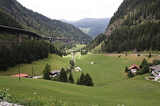
The Brenner Pass is a mountain pass over the Alps which forms the border between Italy and Austria. It is one of the principal passes of the Eastern Alpine range and has the lowest altitude among Alpine passes of the area.

Austria is a predominantly mountainous country in Central Europe, approximately between Germany, Italy and Hungary. It has a total area of 83,871 square kilometres (32,383 sq mi).

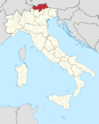
Tyrol is an Austrian federal state. It comprises the Austrian part of the historical Princely County of Tyrol. It is a constituent part of the present-day Euroregion Tyrol–South Tyrol–Trentino. The capital of Tyrol is Innsbruck.
South Tyrol is an autonomous province in northern Italy. An English translation of the official German and Italian names could be the Autonomous Province of Bolzano – South Tyrol, reflecting the multilingualism and different naming conventions in the area. Together with Trentino, South Tyrol forms the autonomous region of Trentino-Alto Adige/Südtirol. The province is the northernmost of Italy, the second largest with an area of 7,400 square kilometres (2,857 sq mi), and has a total population of about 534,000 inhabitants as of 2021. Its capital and largest city is Bolzano.

The Stubai Alps is a mountain range in the Central Eastern Alps of Europe. It derives its name from the Stubaital valley to its east and is located southwest of Innsbruck, Austria. Several peaks form the border between Austria and Italy. The range is bounded by the Inn River valley to the north; the Sill River valley (Wipptal) and the Brenner Pass to the east ; the Ötztal and Timmelsjoch to the west, and to the south by tributaries of the Passer River and Eisack.
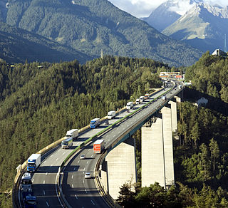
The Europa Bridge or Bridge of Europe (Europabrücke) is a 777-metre-long (2,549 ft) bridge carrying the A13 Brenner Autobahn over the 657-metre (2,156 ft) Wipp valley just south of Innsbruck, Tyrol, Austria. The bridge spans the Sill River, and forms part of the main route across the Alps from western Austria to South Tyrol in Italy. It is also part of the main route between southeastern Germany and northern Italy.
The Bezirk Innsbruck-Land is an administrative district (Bezirk) in Tyrol, Austria. It encloses the Statutarstadt Innsbruck, and borders Bavaria (Germany) in the north, the district Schwaz in the east, South Tyrol in Italy to the south, and the district of Imst in the west.
Reschen Pass is a mountain pass across the main chain of the Alps, connecting the Upper Inn Valley in the northwest with the Vinschgau region in the southeast. Since 1919, the border between South Tyrol, Italy and Tyrol, Austria has approximately followed the watershed, the pass summit at a height of 1,504 metres (4,934 ft) being completely on Italian territory.

The Eastern Alps are usually defined as the area east of a line from Lake Constance and the Alpine Rhine valley, up to the Splügen Pass at the Alpine divide, and down the Liro River to Lake Como in the south. The peaks and mountain passes are lower than the Western Alps, while the range itself is broader and less arched.

Franzensfeste is a comune and a village in South Tyrol in northern Italy. It is named after the large Franzensfeste Fortress erected from 1833 to 1838 and Franzensfeste station is also known as an important railway hub.

The Brenner Base Tunnel is a 55-kilometre-long (34 mi) railway tunnel under construction through the base of the Eastern Alps beneath the Brenner Pass. Once completed, the Brenner Base Tunnel will rank as either the second or third longest railway tunnel in the world, depending on the definition employed. It will be surpassed in length only by the Gotthard Base Tunnel in Switzerland and, depending on the relative completion dates of these projects, the Mont d'Ambin Base Tunnel between France and Italy. When combined with the Inntal Tunnel, which forms part of the existing Innsbruck bypass, the Brenner Base Tunnel will reach a length of 64 kilometres (40 mi), making it the longest underground railway connection in the world.
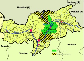
Eisack Valley is a district in South Tyrol, Italy. It comprises the middle part of the valley of the Eisack, from Franzensfeste in the north to Waidbruck in the south.

Wipp Valley is a district in the northern part of the Italian province of South Tyrol. It comprises the South Tyrolean part of the larger geographically defined Wipptal, stretching from Brenner Pass in the north down the upper Eisack (Isarco) river to Franzensfeste in the south. It was separated from neighbouring Eisacktal district in 1980.

The Alpine Brigade "Orobica" was a light Infantry brigade of the Italian Army, specializing in mountain warfare. Its core units were Alpini, the mountain infantry corps of the Italian Army, that distinguished itself in combat during World War I and World War II.

Nauders is a municipality in the district of Landeck in the Austrian state of Tyrol.

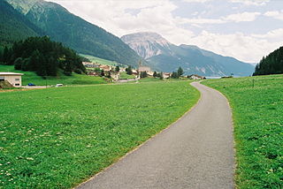
Steinach am Brenner is a market town in the district of Innsbruck-Land in the Austrian state of Tyrol located south of Innsbruck in the Wipptal at the Sill River.

The Brenner Autobahn refers to a major European truck route that connects Innsbruck in Austria to Verona in northern Italy.

Innsbruck Hauptbahnhof is the main railway station in Innsbruck, the capital city of the Austrian federal state of Tyrol. Opened in 1853, the station is a major hub for western and central Austria. In 2019, it was the 8th-busiest station in the country, and the 2nd-busiest outside of Vienna after only Linz Hauptbahnhof, with 315 train movements and 38,500 passengers daily.

The Brenner Railway is a major line connecting the Austrian and Italian railways from Innsbruck to Verona, climbing up the Wipptal, passing over the Brenner Pass, descending down the Eisacktal to Bolzano/Bozen, then further down the Adige Valley to Rovereto/Rofreit, and along the section of the Adige Valley, called in Italian the "Vallagarina", to Verona. This railway line is part of the Line 1 of Trans-European Transport Networks (TEN-T). It is considered a "fundamental" line by the state railways Ferrovie dello Stato (FS).
Tyrol is a historical region in the Alps of Northern Italy and western Austria. The area was historically the core of the County of Tyrol, part of the Holy Roman Empire, Austrian Empire and Austria-Hungary, from its formation in the 12th century until 1919. In 1919, following World War I and the dissolution of Austria-Hungary, it was divided into two modern administrative parts through the Treaty of Saint-Germain-en-Laye:
