Related Research Articles

Wilhelm Heinrich Walter Baade was a German astronomer who worked in the United States from 1931 to 1959.

Capella is a lunar impact crater 49 km (30 mi) in diameter that lies to the north of the Mare Nectaris, in a rugged region with many small impact craters. It was named after Roman astronomer Martianus Capella. It intrudes slightly into the eastern rim of the crater Isidorus, a feature only slightly smaller in diameter.

Baade is a lunar impact crater that is located near the southwest limb of the Moon on the near side, to the southwest of the enormous Mare Orientale impact basin. The area to the east of this crater forms the junction between the 280-km-long Vallis Bouvard to the north and the narrower, 160-km-long Vallis Baade to the south-southeast. Both valleys radiate away from the impact basin to the north.

Shaler is a lunar impact crater that lies on the southeast interior edge of the Montes Cordillera mountain ring that surrounds the immense Mare Orientale formation. It is located near the southwest limb of the Moon on the near side, and so is viewed nearly from on edge from the Earth. Just to the northwest of the crater is the slightly smaller crater Wright.

Sikorsky is a crater on the far side of the Moon. It is situated behind the southeastern limb of the Moon, just out of sight from the Earth. It lies to the northwest of the huge walled plain Schrödinger. To the northwest is the smaller crater Moulton.

Catalán is a small lunar impact crater that lies almost along the southwest limb of the Moon. At this position the crater is ill-suited for observation from the Earth as it is viewed almost from the side, and visibility is subject to libration effects. It lies to the west of the somewhat larger crater Baade, and south-southeast of Graff. This region is located in the outer southeastern part of the skirt of ejecta that surrounds the Mare Orientale impact basin, and the nearby surface is rugged and streaky. This crater is named after the Spanish scientist Miguel Antonio Catalán Sañudo (1894–1957) for his contributions to spectroscopy, an important exploratory tool in astronomy.

Montes Cordillera is a mountain range on the Moon. This feature forms the outer wall of peaks that surround the Mare Orientale impact basin, the inner ring being formed by the Montes Rook. The center of the range is located at selenographic coordinates 17.5° S, 81.6° W, and the diameter is 574 km (357 mi).

Vallis Rheita is a linear valley on the near side of the Moon. It is located in the southeastern quadrant, and is oriented radially to Mare Nectaris. This valley appears to share a common origin with the Vallis Snellius to the northeast, as both are oriented radially with Mare Nectaris.

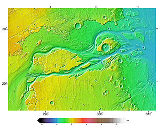
Uzboi Vallis is a valley lying situated within the Margaritifer Sinus quadrangle (MC-19) region on Mars. It is named after the Uzboy dry channel, now in Turkmenistan, which repeatedly served as the main channel of the Amu Darya river. The valley begins on the northern rim of the Argyre basin, and cuts through several craters, before ending at Holden crater.

Ares Vallis is an outflow channel on Mars, named after the Greek name for Mars: Ares, the god of war; it appears to have been carved by fluids, perhaps water. The valley 'flows' northwest out of the hilly Margaritifer Terra, where the Iani Chaos depression 180 km (110 mi) long and 200 km (120 mi) wide) is connected to the beginning of Ares Vallis by a 100 km (62 mi) wide transition zone centered on 342.5° East and 3° North. It then continues through the ancient Xanthe Terra highlands, and ends in a delta-like region of Chryse Planitia. Ares Vallis was the landing site of NASA's Mars Pathfinder spacecraft, which studied a region of the valley near the border with Chryse in 1997.

The Memnonia quadrangle is one of a series of 30 quadrangle maps of Mars used by the United States Geological Survey (USGS) Astrogeology Research Program. The Memnonia quadrangle is also referred to as MC-16.
Baade may refer to:
Vallis Baade is a 203 km long sinuous valley on the Moon running south-southeast from the crater Baade and centered at 45.9°S 76.2°W. It has the same namesake as the crater, the German astronomer Walter Baade.

The Elysium quadrangle is one of a series of 30 quadrangle maps of Mars used by the United States Geological Survey (USGS) Astrogeology Research Program. The Elysium quadrangle is also referred to as MC-15.

The Lunae Palus quadrangle is one of a series of 30 quadrangle maps of Mars used by the United States Geological Survey (USGS) Astrogeology Research Program. The quadrangle is also referred to as MC-10. Lunae Planum and parts of Xanthe Terra and Chryse Planitia are found in the Lunae Palus quadrangle. The Lunae Palus quadrangle contains many ancient river valleys.
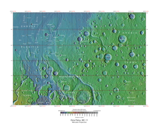
The Oxia Palus quadrangle is one of a series of 30 quadrangle maps of Mars used by the United States Geological Survey (USGS) Astrogeology Research Program. The Oxia Palus quadrangle is also referred to as MC-11.
Outflow channels are extremely long, wide swathes of scoured ground on Mars. They extend many hundreds of kilometers in length and are typically greater than one kilometer in width. They are thought to have been carved by huge outburst floods.

Enipeus Vallis is a valley in the northern hemisphere of the planet Mars. It is centered at lat. 37°N, long. 267°E in the Arcadia quadrangle (MC-3) between the large volcano Alba Mons and the Tempe Terra plateau. The valley follows a gently sinuous, north-south path for a distance of about 357 km (222 mi). It is likely an ancient watercourse that formed during the early Hesperian period, around 3.7 billion years ago.

Peace Vallis is an ancient stream valley on the northern rim of Gale Crater on the planet Mars. It is notable for its associated alluvial fan which lies near the Mars Science Laboratory Curiosity landing site. The valley and alluvial fan provide evidence for geologically recent (Amazonian-aged) fluvial activity and sustained water flow on Mars. Recent high-resolution orbital images of Peace Vallis and its watershed also suggest that at least one glacial episode affected Gale crater. All of this evidence has implications for the history of water on Mars and the planet's long-term habitability. Understanding Peace Vallis and its fan also provides geologic context for the rocks observed on the ground by the Curiosity rover.

The Mendel-Ryberg Basin is a Nectarian impact basin on the southwestern limb of the moon. It is named after the crater Mendel on the west margin and the smaller crater Rydberg north of the center of the basin. The basin is due south of the larger, younger Orientale basin, and ejecta and other geomorphological effects from the younger basin have overprinted the older one.
References
- ↑ Wood, C.A. (2004). "Lunar Rilles Catalog (UAI)". Archived from the original on 2016-01-06. Retrieved 2007-03-17.
| | This article related to the Moon is a stub. You can help Wikipedia by expanding it. |
