
Pineview Dam is located in Ogden Canyon, 7 miles (11 km) east of Ogden, Utah, United States.

The Millers River is a 52.1-mile-long (83.8 km) river in northern Massachusetts, originating in Ashburnham and joining the Connecticut River just downstream from Millers Falls, Massachusetts. Sections of the river are used for whitewater kayaking, and a section upriver is popular with flatwater racers, and the river is known locally as a good place for pike fishing.

The Holyoke Canal System is a system of power canals in Holyoke, Massachusetts. It is split into three canals based on elevation and distance from the inlet at the Holyoke Dam- the First Level Canal, Second Level Canal, and Third Level Canal. Constructed over a period between 1847 and 1892, the Canal System, along with the Dam, is recognized as a Historic Mechanical Engineering Landmark by the American Society of Mechanical Engineers for its use in the development of the Venturi meter by Clemens Herschel, the first means of measuring large-scale flows, and the McCormick-Holyoke Turbine by John B. McCormick, which doubled the efficiency of turbines to more than 80% in its time.

Folsom Dam is a concrete gravity dam on the American River of Northern California in the United States, about 25 mi (40 km) northeast of Sacramento. The dam is 340 ft (100 m) high and 1,400 ft (430 m) long, flanked by earthen wing dams. It was completed in 1955, and officially opened the following year.
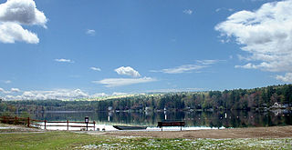
Lake Wyola is a lake located in Shutesbury, Massachusetts, United States.
The Clyde River is a tributary of Lake Memphremagog, over 33.5 miles (54 km) long, in northern Vermont in the United States. It is the easternmost of the four major rivers in Orleans County. It is the most powerful of the four within Orleans County, powering several turbines at damsites. It is part of the Northern Forest Canoe Trail.
Seymour Lake is located in the town of Morgan in Orleans County, Vermont, an area known as the Northeast Kingdom. The lake was named for Israel Seymour, one of the original grantees. Natives called it Namagonic. It is one of only two deep, cold, and oligotrophic lakes in the Clyde River system.
Mary Elmer Lake is a reservoir on the Cohansey River in Cumberland County, New Jersey, used for water-supply and recreation purposes.
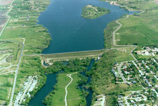
The Jamestown Dam is a rolled-earth dam spanning the James River in Stutsman County in the U.S. state of North Dakota, serving the primary purpose of flood control. It is north of the city of Jamestown, North Dakota. Built from April 1952 to September 1953, the dam measures 1,418 feet (432 m) long at the crest and 85 feet (26 m) high. It impounds the James River to form the Jamestown Reservoir. A small islet lies shortly upstream of the dam, where the James River previously split into two channels.
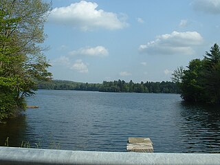
Miscoe Lake is a reservoir in Cumberland, Providence County, Rhode Island. It is about 0.8 miles (1.3 km) long and the northern tip of the lake lies in Wrentham, Norfolk County, Massachusetts. At normal levels it has a surface area of 49 acres (20 ha). It has also been known as Grants Mills Pond and Miso Meadow Pond.
Lake Ashmere, or Ashmere Lake, is a small lake in rural Berkshire County of Massachusetts, located in Peru and Hinsdale, Massachusetts.
New Mill Pond is a lake in Smithtown on the Northeast Branch River in Suffolk County, New York and is used for recreational purposes. Construction was completed in 1825. It has a normal surface area of 109 acres (0.44 km2). It is owned by Suffolk County Parks Department.

Stony Brook is a stream largely running through Lincoln and Weston, Massachusetts, then forming the Weston/Waltham boundary, and emptying into the Charles River across from the Waltham/Newton boundary. It has two tributaries, Cherry Brook and Hobbs Brook, and its watershed includes about half of Lincoln and Weston as well as parts of Lexington and Waltham. Since 1887, it has been the water supply for Cambridge, along with the Hobbs Brook Reservoir.

Watershops Pond is a lake in the city of Springfield, Massachusetts. Located in the Upper Hill neighborhood, it is the city's second-largest body of water, after the Connecticut River. Watershops Pond features 7 miles of shorelines and 186 acres. It was a major site for fishing, featuring species ranging from Black Crappie, Bluegill, Brown Trout, Chain Pickerel, Channel Catfish, Common Carp, Largemouth Bass, Pumpkinseed, Rainbow Trout, and Yellow Bass. The city after multiple lowering of the dam draining the pins for lengthy periods had destroyed the habitat. Not only had it decimated the fish population leaving primarily pumpkinseed, calico bass, and carp. The pond was formed by damming the Mill River, which flows out of the westernmost end and continues 1.25 miles until its confluence with the Connecticut River.
The Mill River is a 1.25-mile-long (2.01 km) tributary of the Connecticut River in Springfield, Massachusetts. It flows from Watershops Pond to its confluence with the Connecticut River. It is referred to as "The Miracle Mile" in a 2009 master's thesis that outlines possibilities for reclaiming the river's mouth as a recreational area. As of 2011, the final 350 feet (110 m) of the river, including its mouth, is confined in a pipe underneath Interstate 91, railroad tracks and a car dealership. Many Springfield residents have bemoaned the loss of the Mill River as a recreational area, and hope to gain greater access to both it and the Connecticut River in upcoming years. As it has for over a century, today the Mill River serves as a barrier between Springfield neighborhoods. Surrounding it are some of the most densely urbanized locations in Springfield.
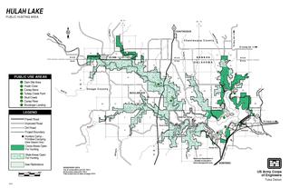
Hulah Lake is a man-made reservoir that was created by the United States Army Corps of Engineers damming the Caney River in northeastern Osage County, Oklahoma, within the Osage Indian Reservation. Hulah is an Osage word meaning "eagle”, and was the name of the farming community that was located in the valley before the construction of the dam. The primary purpose of the lake is flood control. It has become a popular recreation area. According to the U. S. Army Corps of Engineers, the Hulah Lake project includes a public hunting area, bringing the total project area to 21,510 acres (8,700 ha).

Okatibbee Dam is a dam in Lauderdale County, Mississippi.

The Tongue River Dam is a dam in Big Horn County, Montana, a few miles north of the Wyoming state border. It impounds the Tongue River, creating the Tongue River Reservoir.
Mahlstedt's Ice Pond, commonly referred to as Huguenot Lake, is a man-made lake located in central New Rochelle in Westchester County, New York. Constructed in 1885, the lake is impounded by the Mahlstedt Reservoir Dam on a tributary of Pine Brook. The dam is of earthen construction and rock fill, with a height of 15 feet (4.6 m) and a length of 7,000 feet (2,100 m). It has a normal surface area of 14 ares (15,000 sq ft), a capacity of 70 acre-feet (86,000 m3), and normal storage of 56 acre-feet (69,000 m3).
Reservoir 3 is a man-made reservoir located in the northern portion of the city of New Rochelle along the New Rochelle - Eastchester boundary in Westchester County, New York. Constructed in 1908, the reservoir is impounded by the New Rochelle "Reservoir 3 dam" on the Hutchinson River. The dam is of earthen construction, with a height of 30 feet (9.1 m) and a length of 450 feet (140 m). It has an area of about 30 acres (12 ha), and a capacity of about 128 million US gallons (480,000 m3). Maximum discharge is 1,815 cubic feet (51.4 m3) per second. Its capacity is 498 acre-feet (614,000 m3). Normal storage is 220 acre-feet (270,000 m3). It drains an area of 2.85 square miles (7.4 km2). The reservoir is currently owned by the Westchester County Department of Parks and Recreation.
