The Van Scoy Burial Ground, historically significant for its connection to educational and agricultural practices, is a site located at Northwest Harbor in East Hampton, a town in Suffolk County, New York, United States. This location holds unique significance as it marks the site of a once-thriving schoolhouse and its associated history with the Van Scoy family, the local community, and their mutual arrangements. [1]
The construction of the schoolhouse began in 1827 and was built as a single-room wooden structure. Cconstructed at a cost of $250 it was designed to accommodate around thirty to forty pupils, along with their teacher. The teacher, in turn, was compensated with an annual salary of $50. [2]
Today, the Van Scoy Burial Ground serves as a historical marker, preserving the memory of the schoolhouse, the Van Scoy family, and their unique arrangements with the town of East Hampton. While the original wooden structure has long since disappeared, the foundation stones that once supported the schoolhouse remain as a tangible link to the past. The site offers a glimpse into a bygone era, where education, agriculture, and community cooperation intertwined to shape the landscape of East Hampton. [3]
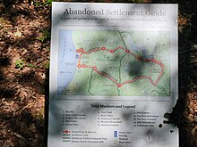
The Burying ground stands as part of the Northwest "Ghost town" settlement, a nature trail that winds thru the Van Scoy Homestead, to Northwest Harbor, East Hampton's first harbor on the South Fork of Long Island and back on the 'whalebone landing road'. During the 18th century, this settlement encompassed fifteen expansive farms, a mill, a sawmill, and various wharves and warehouses situated along the shores of Northwest Harbor. Both the Northwest trail and the Paumanok Path intersect in the Old Grace Estate [4] on Barcelona Neck.
In recognition of its historical and cultural significance, [5] the Van Scoy Burial Ground was added to the NRHP on January 27, 2023. NRHP#100008577 [6]
Northwest Landing, Suffolk County, New York, USA
Suffolk County is the easternmost county in the U.S. state of New York, constituting the eastern two-thirds of Long Island. It is bordered to its west by Nassau County, to its east by Gardiners Bay and the open Atlantic Ocean, to its north by Long Island Sound, and to its south by the Atlantic Ocean.
Northwest Harbor is a hamlet and census-designated place (CDP) in the Town of East Hampton, Suffolk County, New York, United States. The population was 3,317 at the 2010 census.
Sag Harbor is an incorporated village in Suffolk County, New York, United States, in the towns of Southampton and East Hampton on eastern Long Island. The village developed as a working port on Gardiners Bay. The population was 2,772 at the 2020 census.
Springs is a census-designated place (CDP) roughly corresponding to the hamlet by the same name in the Town of East Hampton in Suffolk County, New York, United States, on the South Fork of Long Island. As of the 2010 United States Census, the CDP population was 6,592.
The Hamptons, part of the East End of Long Island, consist of the towns of Southampton and East Hampton, which together compose the South Fork of Long Island, in Suffolk County, New York. The Hamptons are a popular seaside resort and one of the historical summer colonies of the northeastern United States.
Hampton Roads is a body of water in the United States that serves as a wide channel for the James, Nansemond, and Elizabeth rivers between Old Point Comfort and Sewell's Point near where the Chesapeake Bay flows into the Atlantic Ocean. It also gave its name to the surrounding metropolitan region located in the southeastern Virginia and northeastern North Carolina portions of the Tidewater Region.
Southampton, officially the Town of Southampton, is a town in southeastern Suffolk County, New York, partly on the South Fork of Long Island. As of the 2020 U.S. census, the town had a population of 69,036. Southampton is included in the stretch of shoreline prominently known as the Hamptons.
The Town of East Hampton is a town in southeastern Suffolk County, New York United States. It is located at the eastern end of the South Shore of Long Island. It is the easternmost town in the state of New York. At the time of the 2020 United States census, it had a total population of 28,385.
Peconic County is a proposed new county on Long Island in the U.S. state of New York that would secede the five easternmost towns of Suffolk County: East Hampton, Riverhead, Shelter Island, Southampton and Southold, plus the Shinnecock Indian Reservation.
The South Fork of Suffolk County, New York is a peninsula in the southeastern section of the county on the South Shore of Long Island. The South Fork includes most of the Hamptons. The shorter, more northerly peninsula is known as the North Fork.
The Paumanok Path is a 125-mile (201 km) hiking trail in New York on Long Island that goes from Rocky Point to Montauk Point State Park. It travels through four towns in Suffolk County: Brookhaven, Riverhead, Southampton and East Hampton. It is marked by white trail blazes.
County Route 111 (CR 111) is a north–south county road in Suffolk County, New York, in the United States. It runs northwest and southeast from New York State Route 27 (NY 27) at exit 62 near Eastport to Interstate 495 (I-495) at exit 70 in Manorville. It serves as a connecting route between central Long Island and the Hamptons. The road is known as Captain Daniel Roe Highway, for Captain Daniel Roe (1740–1820) of Selden, who served in the French and Indian War and was a captain in the Revolutionary War. Within Manorville, the road is also known as Eastport Manor Road. It also appears on maps as Port Jefferson-Westhampton Road, for the communities in which the route was originally intended to have its north and south endpoints in.
Mercator Cooper was a ship's captain who is credited with the first formal American visit near Edo, Japan and the first formal landing on the mainland East Antarctica.
Bridgehampton Union Free School District is a public school district located in the Town of Southampton on Long Island, in Suffolk County, New York, United States. It is roughly co-extensive with the hamlet of Bridgehampton, but also serves parts of Noyack, unincorporated Sag Harbor, and unincorporated Sagaponack.
The Northwest Alliance is a New York state based organization of citizens formed in the early 1980s whose goal was to gain protection of two unoccupied parcels of East Hampton, Long Island, comprising The Grace Estate, Barcelona Neck, Northwest Creek, Little Northwest Creek and Northwest Harbor.
Nancy (Boyd) Willey 1902–1998, was an American environmentalist and historic preservationist from Sag Harbor, New York. She was the founding president and historian for the Old Sagg-Harbour Committee.
Sagaponack Common School District is a public school district located in Sagaponack on Long Island, in Suffolk County, New York, United States. It is roughly co-extensive with the village of Sagaponack, which is part of the town of Southampton.
Springs Union Free School District is a public school district located in East Hampton on Long Island, in Suffolk County, New York, United States. It educates students in the hamlet of Springs and the privately-owned Gardiners Island.
The Tide Mill at Southold, erected in the 1640's by Thomas Benedict, holds a place of distinction in American history as the first recorded English mill in the New World. It paved the way for future tide mills and contributed to the economic growth of the Southold community.