Related Research Articles

The City of Central Coast, a peri-urban region in the Australian state of New South Wales (NSW), lies on the Tasman Sea coast on the northern outskirts of Sydney and south of Lake Macquarie.

The Riverina is an agricultural region of South-Western New South Wales (NSW), Australia. The Riverina is distinguished from other Australian regions by the combination of flat plains, warm to hot climate and an ample supply of water for irrigation. This combination has allowed the Riverina to develop into one of the most productive and agriculturally diverse areas of Australia. Bordered on the south by the state of Victoria and on the east by the Great Dividing Range, the Riverina covers those areas of New South Wales in the Murray and Murrumbidgee drainage zones to their confluence in the west.
Vance may refer to:

Leeton is a town located in the Riverina region of southern New South Wales, Australia. Situated approximately 550 km west of Sydney and 450 km north of Melbourne in the Murrumbidgee Irrigation Area, it is the administrative centre of the Leeton Shire Council local government area. Leeton's urban population in 2016 was 8,623. Situated in one of the most productive farming regions in the state, the town was designed by Walter Burley Griffin and purpose-built for the irrigation schemes announced by the New South Wales government in the early 1900s. Citrus, rice, cotton, grapes, walnuts and wheat farms can all be found throughout the Leeton Shire. Leeton is renowned as Australia's Rice Capital and as The Heart of SunRice Country, as it is home to the SunRice headquarters. Other industry includes Freedom Foods, the Daily Drinks Co., JBS Australia, Webster Limited and Murrumbidgee Irrigation Limited.

Yanco is a village with a population of 505 in Leeton Shire in south western New South Wales, Australia. Yanco is a Wiradjuri aboriginal language word meaning the sound of running water. Yanco is located 3 kilometres (1.9 mi) from Leeton along Irrigation Way. Yanco is home to the Powerhouse Museum, McCaughey Park, Murrumbidgee Rural Studies Centre and Yanco Agricultural High School.

Narrandera Airport is a small regional airport in the local government area of Narrandera in the Riverina region of New South Wales, Australia. The airport is located 4 nautical miles northwest of Narrandera along Irrigation Way. The airport services the towns of Leeton and Narrandera as it is located between the two towns.

Leeton railway station is a heritage-listed former goods yard and railway station and now bus station and railway station is located on the Yanco-Griffith line at Dunn Avenue in Leeton in the Leeton Shire local government area of New South Wales, Australia. It is also known as Leeton Railway Station and yard group. The property is owned by RailCorp, an ageiny of the Government of New South Wales. It was added to the New South Wales State Heritage Register on 2 April 1999.
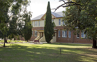
Leeton High School is a government-funded co-educational comprehensive secondary day school, located in Leeton in the Riverina region of New South Wales, Australia.

Leeton Shire is a local government area in the Riverina region of New South Wales, Australia. The Shire is located adjacent to the Murrumbidgee River and falls within the Murrumbidgee Irrigation Area.

The Irrigation Way is a major regional highway that runs approximately 81 kilometres (50 mi) through the Murrumbidgee Irrigation Area in south western New South Wales, Australia. Irrigation Way runs through three local government areas.
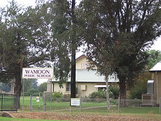
Wamoon is a village in Leeton Shire in the Riverina region of New South Wales, Australia. Wamoon is located 8.8 kilometres (5.5 mi) from Leeton along the Irrigation Way to the Leeton CBD and Henry Lawson Drive to the Leeton suburb of Wattle Hill. Wamoon provides a village of homes to the farmers of northern Leeton and there is a small primary school known as Wamoon Public School.

The Murrumbidgee Irrigation Area (MIA) is geographically located within the Riverina area of New South Wales. It was created to control and divert the flow of local river and creek systems for the purpose of food production. The main river systems feeding and fed by the area are the Murrumbidgee and the Tumut. It is one of the most diverse and productive regions in Australia contributing over A$5 billion annually to the Australian economy.

Stanbridge is a town/community in Leeton Shire, New South Wales, Australia. It is in the central part of the Riverina. It is situated by road, about 6 kilometres (3.7 mi) east from Whitton, 8 kilometres (5.0 mi) north west from Gogeldrie and 20 kilometres (12 mi) west of Leeton. At the 2011 census, Stanbridge had a population of 414 people.

The Somerset Region is a local government area located in the West Moreton region of South East Queensland, Australia, about 100 kilometres (62 mi) northwest of Brisbane and centred on the town of Esk. It was created in 2008 from a merger of the Shire of Esk and the Shire of Kilcoy. It is commonly known as the Brisbane Valley, due to the Brisbane River which courses through the region, although significant parts of the region lie outside the hydrological Brisbane Valley itself.
NBN Co Limited is an Australian government-owned corporation tasked to design, build and operate Australia's National Broadband Network as a monopoly wholesale broadband provider. It reports to two shareholder ministers: the Minister for Finance and the Minister for Communications. Restrictions on competing broadband providers are achieved through carrier license conditions (CLCs).
Alan Robert Lindsay "Lin" Gordon was an Australian politician. He was the Labor member for Murrumbidgee in the New South Wales Legislative Assembly from 1970 to 1984. He was Minister for Conservation and Water Resources from 1976 to 1981, Minister for Local Government and Lands from 1981 to 1984, and Minister for Lands and Ports for a few months in 1984.

The National Broadband Network (NBN) is an Australian national wholesale open-access data network project. It includes wired and radio communication components rolled out and operated by NBN Co Limited. Internet service providers, known under NBN as retail service providers or RSPs, contract with NBN to access the network and sell fixed Internet access to end users.

The Irrigation Record was a fortnightly newspaper published in Leeton, New South Wales, Australia from 15 February 1913 to 15 June 1917 by the NSW Water Conservation and Irrigation Commission. Its purpose was to educate new settlers of the fledgling Murrumbidgee Irrigation Area (MIA), about agricultural methods, irrigation techniques, crops, stock and machinery.

The Leeton District Lands Office is a heritage-listed administration office located at Chelmsford Place, Leeton in the Leeton Shire local government area of New South Wales, Australia. It was designed by J. M. S. Woore of the Water Conservation and Irrigation Commission and built in 1937. It is also known as the Water Conservation and Irrigation Commission. The property is owned by Department of Planning and Infrastructure, a department of the Government of New South Wales. It was added to the New South Wales State Heritage Register on 2 April 1999.
Yanko Shire was a local government area in the Riverina region of New South Wales, Australia.
References
- ↑ "Leeton Shire is the heart of opportunity" (PDF). Leeton Shire Council. Retrieved 6 May 2020.
- ↑ "Leetoria Windows & Doors > Home". leetoria.com.au.
- ↑ "Animals In the Pound - Leeton Shire Council Rehoming Organisation Number is R251000161". Leeton Shire Council. Retrieved 6 May 2020.
- ↑ Ley, Sussan. "NBN build underway in Leeton" . Retrieved 13 May 2020.
- ↑ "Confirmation NBN will be extended to Vance Industrial Estate". The Irrigator. Retrieved 13 May 2020.
| This Riverina geography article is a stub. You can help Wikipedia by expanding it. |