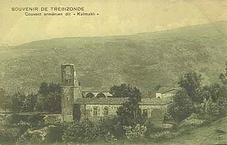
Kaymaklı Monastery is a ruined Armenian Apostolic monastery near Trabzon, Turkey.

Arzakan, is a village in the Kotayk Province of Armenia. The Aghveran resort is located in Arzakan. There are the large ruins of the 10th- or 11th-century Neghutsi Vank, located along a ravine to the northwest of the village. There are also the 13th-century monastic ruins of Ghuki Vank and 13th-century ruins of Surb Gevorg in the vicinity.

Pemzashen is a village in the Shirak Province of Armenia. During the Soviet era a sewing factory, construction materials plant, and a parts factory to supply hydro-electric stations were based out of Pemzashen. After the collapse of the USSR, most of the village's residents have found themselves out of work and many of the men have moved to Russia to find jobs. In the past 15 years, over 300 families have moved away from the village. There is also the problem of a lack of irrigation water for crops or household gardens, and the land around the village is not flat or fertile. Plans are currently underway to put in an irrigation system.

Apaga is a town in the Armavir Province of Armenia.
Aramus is a town in the Kotayk Province of Armenia.
Artsvanik is a village and rural community (municipality) in the Syunik Province of Armenia. The National Statistical Service of the Republic of Armenia (ARMSTAT) reported its population as 578 in 2010, down from 652 at the 2001 census.
Gyadikvank is a former town in the Vayots Dzor Province of Armenia.
Herher is a village in the Vayots Dzor Province of Armenia. It was once a fief of the Orbelian vassals, the Shahurnetsi family in the 13th century. Within the village is a 19th-century church of Saint Gevorg, and south is a shrine of Grigor Lusavorich from 1296 with Saint Gevorg or Chiki Vank of 1297. Southeast one km on a hill is the small Kapuyt Berd. Upon a hilltop one km northeast is Saint Sion Monastery, first mentioned in the 8th century. At the complex are the churches of Saint Sion and Saint Astvatsatsin. Other sites of historical significance are in close proximity to Herher, such as village ruins with khachkars of the 14th century.

Hermon, is a village in the Vayots Dzor Province of Armenia. Hermon is identified with the monastic center of "Hermoni Vank" dating from the 9th century.

Madina, is a village in the Gegharkunik Province of Armenia, founded in 1922. Just west of town is Mount Armaghan, an extinct volcano that rises 450 meters higher than the surrounding plain with a small crater lake at its center.

Makenis is a town in the Gegharkunik Province of Armenia. The Makenyats Vank in the town was a major cultural and educational center of medieval Gegharkunik, with structures dating from the 9th to 13th centuries.
Ttujur is a village in the Aragatsotn Province of Armenia. The village 's church is dedicated to Saint Harutyun. The village also contains a 17th-century shrine called "Karmir Vank".

Saldaş is a village in the Qubadli Rayon of Azerbaijan.
Kusapat is an Armenian populated village South Caucasus. According to the jurisdiction of the unrecognized Nagorno-Karabakh Republic, actually controlling the village, it is situated in Martakert district of NKR. According to the jurisdiction of Azerbaijan, it is in the Tartar Rayon of it. The population is about 237 people, mostly Armenians, and several Greeks.
Çardaqlı is a village in the Tartar Rayon of Azerbaijan.
Kyurdalilyar is a village in the Goygol Rayon of Azerbaijan.

Saint Sarkis Monastery of Gag is a ruined, medieval Armenian Apostolic monastery in the Qazakh Rayon of the Republic of Azerbaijan. It is located about 500 metres to the east of the present-day border of Armenia, and four kilometres west of the village of Dash Salakhly. The monastery is built at the top of Gag Mountain, at an altitude of 922 metres above sea level and 420 metres from the foot of the mountain.

Samsonavank Monastery is a 12th-13th century monastery easiest reached via Yenokavan in the Tavush Province of northern Armenia. It is a small monastic complex that is located in a forested area along the slopes of a mountain approximately 6 km to the south of Deghdznuti Vank of the 13th century and not far from the medieval fort of Berdakar.

Aghjots Vank ; also known as the Saint Stephen Monastery of Goght, is a 13th-century monastery situated along a tributary of the Azat River Valley within the Khosrov State Reserve located half a mile walk from the hamlet of Mets Gilanlar, and near the villages of Goght and Garni in the Ararat Province of Armenia. Not far from this location and also within the reserve is the fortress of Kakavaberd and the monastic complex of Havuts Tar.

Vank is an Armenian-populated village located in the disputed region of Nagorno-Karabakh. Its population in 2005 stood at 1,284.