Krasnoarmeysky District is the name of several administrative and municipal divisions in Russia. The districts are generally named for the Red Army.

Spassk-Dalny, sometimes called simply Spassk, is a town in Primorsky Krai, Russia, situated on the Prikhankayskaya Flatland on the coast of Khanka Lake. Population: 44,173 (2010 Census); 51,691 (2002 Census); 60,060 (1989 Census).
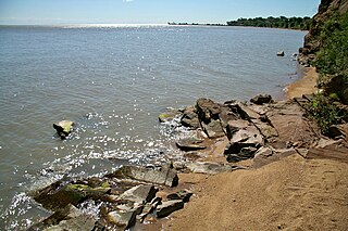
Khankaysky District is an administrative and municipal district (raion), one of the twenty-two in Primorsky Krai, Russia. It is located in the west of the krai on the western bank of Lake Khanka and borders with Pogranichny District in the southwest, Khorolsky District in the southeast, and with Heilongjiang Province of China in the west. The area of the district is 2,689.0 square kilometers (1,038.2 sq mi). Its administrative center is the rural locality of Kamen-Rybolov. Population: 24,666 (2010 Census); 28,939 (2002 Census); 31,122 (1989 Census). The population of Kamen-Rybolov accounts for 44.2% of the district's total population.

Khasansky District is an administrative and municipal district (raion), one of the twenty-two in Primorsky Krai, Russia. It is located in the southwest of the krai, wedged between the Tumen River and the Peter the Great Gulf, and shares a border with both China and North Korea. The area of the district is 4,130.0 square kilometers (1,594.6 sq mi). Its administrative center is the urban locality of Slavyanka. Population: 35,541 (2010 Census); 37,459 (2002 Census); 43,709 (1989 Census). The population of Slavyanka accounts for 39.5% of the district's total population.

Kavalerovsky District is an administrative and municipal district (raion), one of the twenty-two in Primorsky Krai, Russia. It is located in the central western portion of the krai and borders with the territory of Dalnegorsk Town Under Krai Jurisdiction in the north and northeast, the Sea of Japan in the east, Olginsky District in the south, and with Chuguyevsky District in the west. The area of the district is 4,215.2 square kilometers (1,627.5 sq mi). Its administrative center is the urban locality of Kavalerovo. Population: 25,833 (2010 Census); 29,488 (2002 Census); 36,085 (1989 Census). The population of Kavalerovo accounts for 59.5% of the district's total population.

Lazovsky District is an administrative and municipal district (raion), one of the twenty-two in Primorsky Krai, Russia. It is located in the southeast of the krai on the eastern slopes of the Sikhote-Alin mountain range and its southern spurs. The area of the district is 4,691.5 square kilometers (1,811.4 sq mi). Its administrative center is the rural locality of Lazo. Population: 14,235 (2010 Census); 17,521 (2002 Census); 21,311 (1989 Census). The population of Lazo accounts for 24.1% of the district's total population.

Nadezhdinsky District is an administrative and municipal district (raion), one of the twenty-two in Primorsky Krai, Russia. It is located on the southern coast of the krai. The area of the district is 1,595.7 square kilometers (616.1 sq mi). Its administrative center is the rural locality of Volno-Nadezhdinskoye. Population: 39,161 (2010 Census); 40,197 (2002 Census); 43,012 (1989 Census). The population of Volno-Nadezhdinskoye accounts for 17.1% of the district's total population.

Terneysky District is an administrative and municipal district (raion, one of the twenty-two in Primorsky Krai, Russia. It is located in the north of the krai and borders with Khabarovsk Krai in the north, the Sea of Japan in the east and southeast, the territory of Dalnegorsk Town Under Krai Jurisdiction in the southwest, and with Krasnoarmeysky and Pozharsky Districts in the west. The area of the district is 27,102.2 square kilometers. Its administrative center is the urban locality of Terney. Population: 12,468 ; 14,487 ; 15,273 . The population of Terney accounts for 28.8% of the district's total population.
Chuguyevsky District is an administrative and municipal district (raion), one of the twenty-two in Primorsky Krai, Russia. It is located in the center of the krai. The area of the district is 12,346 square kilometers (4,767 sq mi). Its administrative center is the rural locality of Chuguyevka. Population: 24,937 (2010 Census); 28,913 (2002 Census); 30,909 (1989 Census). The population of Chuguyevka accounts for 48.8% of the district's total population.

Anuchinsky District is an administrative and municipal district (raion), one of the twenty-two in Primorsky Krai, Russia. It is located in the south of the krai and borders with Spassky District in the north, Yakovlevsky District and the territory of Arsenyev Town Under Krai Jurisdiction in the northeast, Chuguyevsky District in the east, Partizansky District in the southeast, the territory of Partizansk Town Under Krai Jurisdiction in the south and southeast, Shkotovsky District in the south and southwest, and with Mikhaylovsky and Chernigovsky Districts in the west. The area of the district is 3,769.4 square kilometers (1,455.4 sq mi). Its administrative center is the rural locality of Anuchino. Population: 14,613 (2010 Census); 16,010 (2002 Census); 18,187 (1989 Census). The population of Anuchino accounts for 30.5% of the district's total population.

Partizansky District is an administrative and municipal district (raion), one of the twenty-two in Primorsky Krai, Russia. It is located in the south of the krai and borders with Chuguyevsky District in the north and northeast, Lazovsky District in the east, the territory of Nakhodka City Under Krai Jurisdiction and the Sea of Japan in the south, the territory of Partizansk Town Under Krai Jurisdiction and Shkotovsky District in the west, and with Anuchinsky District in the northwest and north. The area of the district is 4,253.9 square kilometers (1,642.4 sq mi). Its administrative center is the rural locality of Vladimiro-Alexandrovskoye. Population: 30,238 (2010 Census); 31,666 (2002 Census); 29,455 (1989 Census). The population of Vladimiro-Alexandrovskoye accounts for 18.9% of the district's total population.

Chernigovsky District is an administrative and municipal district (raion), one of the twenty-two in Primorsky Krai, Russia. It is located in the southwest of the krai. The area of the district is 1,840.4 square kilometers (710.6 sq mi). Its administrative center is the rural locality of Chernigovka. Population: 36,230 (2010 Census); 39,554 (2002 Census); 45,782 (1989 Census). The population of Chernigovka accounts for 36.0% of the district's total population.
Dalnerechensky District is an administrative and municipal district (raion), one of the twenty-two in Primorsky Krai, Russia. It is located in the central and western parts of the krai. The area of the district is 7,235.53 square kilometers (2,793.65 sq mi). Its administrative center is the town of Dalnerechensk. Population: 11,344 (2010 Census); 13,995 (2002 Census); 17,057 (1989 Census).

Olginsky District is an administrative and municipal district (raion), one of the twenty-two in Primorsky Krai, Russia. It is located in the southeast of the krai and borders with Kavalerovsky District in the north, the Sea of Japan in the east, southeast, and south, Lazovsky District in the southwest, and with Chuguyevsky District in the west. The area of the district is 6,415.9 square kilometers (2,477.2 sq mi). Its administrative center is the urban locality of Olga. Population: 10,701 (2010 Census); 12,044 (2002 Census); 16,006 (1989 Census). The population of Olga accounts for 37.6% of the district's total population.

Khorolsky District is an administrative and municipal district (raion), one of the twenty-two in Primorsky Krai, Russia. It is located in the southwest of the krai. The area of the district is 1,968.6 square kilometers (760.1 sq mi). Its administrative center is the rural locality of Khorol. Population: 30,281 (2010 Census); 34,555 (2002 Census); 43,557 (1989 Census). The population of Khorol accounts for 35.9% of the district's total population.

Mikhaylovsky District is an administrative and municipal district (raion), one of the twenty-two in Primorsky Krai, Russia. It is located in the southwest of the krai. The area of the district is 2,741.4 square kilometers (1,058.5 sq mi). Its administrative center is the rural locality of Mikhaylovka. Population: 34,437 (2010 Census); 37,541 (2002 Census); 44,150 (1989 Census). The population of Mikhaylovka accounts for 26.6% of the district's total population.

Oktyabrsky District is an administrative and municipal district (raion), one of the twenty-two in Primorsky Krai, Russia. It is located in the southwest of the krai. The area of the district is 1,632.8 square kilometers (630.4 sq mi). Its administrative center is the rural locality of Pokrovka. Population: 30,060 (2010 Census); 34,367 (2002 Census); 39,973 (1989 Census). The population of Pokrovka accounts for 34.5% of the district's total population.

Pogranichny District is an administrative and municipal district (raion), one of the twenty-two in Primorsky Krai, Russia. It is located in the southwest of the krai. The area of the district is 3,750.0 square kilometers (1,447.9 sq mi). Its administrative center is the urban locality of Pogranichny. Population: 23,492 (2010 Census); 25,761 (2002 Census); 26,604 (1989 Census). The population of the administrative center accounts for 43.8% of the district's total population.

Spassky District is an administrative and municipal district (raion), one of the twenty-two in Primorsky Krai, Russia. It is located in the west of the krai. The area of the district is 4,205.98 square kilometers (1,623.94 sq mi). Its administrative center is the town of Spassk-Dalny. Population: 30,475 (2010 Census); 29,570 (2002 Census); 32,653 (1989 Census).
Yakovlevsky District is an administrative and municipal district (raion), one of the twenty-two in Primorsky Krai, Russia. It is located in the center of the krai. The area of the district is 2,400.1 square kilometers (926.7 sq mi). Its administrative center is the rural locality of Yakovlevka. Population: 16,042 (2010 Census); 18,406 (2002 Census); 21,483 (1989 Census). The population of Yakovlevka accounts for 27.9% of the district's total population.
