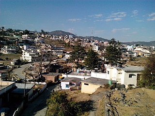
Champawat is a town and a Nagar Palika Parishad in Champawat district in the state of Uttarakhand, India. It is the administrative headquarters of Champawat district. The town was the former capital of the Kumaon Kingdom.

Ganpatipule (Gaṇpatīpuḷē) is a small town located 25 kms north of the city of Ratnagiri in Ratnagiri district on the Konkan coast of Maharashtra, in the sub-continent of India. The town of Chiplun is located to its north.

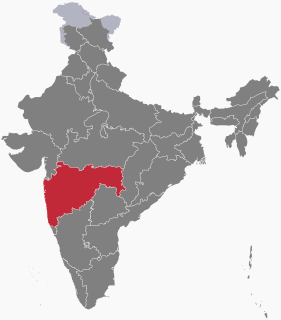
Sindhudurg is an administrative district in the state of Maharashtra in India, which was carved out of the erstwhile Ratnagiri District. The district headquarters are located at Oros. The district occupies an area of 5207 km² and has a population of 849,651 of which 12.59% were urban.

Ranikhet is a hill station and cantonment town in Almora district in the Indian state of Uttarakhand. It is the home for the Military Hospital, Kumaon Regiment (KRC) and Naga Regiment and is maintained by the Indian Army.
Ranikhet is at an altitude of 1,869 metres (6,132 ft) above sea level and within sight of the western peaks of the Himalayas.

Jhalawar is a city in southeastern Rajasthan. It was the capital of the former princely state of Jhalawar, and is the administrative headquarters of Jhalawar District. Jhalawar was once known as Brijnagar.

Palakkad pronunciation (help·info), also known as Palghat, is a city and municipality in the state of Kerala in southern India, spread over an area of 26.60 km2 and is the administrative headquarters of the Palakkad District. The city is situated about 350 kilometres (217 mi) north of state capital Thiruvananthapuram and 54 kilometers south west of Coimbatore, and 66 km north east of Thrissur on the Salem-Kanyakumari National Highway NH 47.

Malvan pronunciation (help·info) is a town and taluka in Sindhudurg District, the southernmost district of Maharashtra State, India, well known for the historically important Sindhudurg Fort. Malvan taluka consists of villages such as Aangnechi Wadi, Achra, Khalchi Devli, Jamdul, Juva, Pankhol, Talasheel and Sarjekot. The main occupation here is fishing with the staple diet of the local people fish curry and rice. The town produces Alphonso mangoes and is also known for sweets such as Malvani Khaja made from gram-besan flour and coated jaggery as well as Malvani Ladoos. Other sweets that attract tourists are Konkani meva, Aambawadi, Fanaspoli, Dryfriuts, Kajuwadi, Naralachya Wadya, Malvani Masale. Malvani Dashavtar, a drama-play based on mythological stories, is an important cultural element of the area.

Dongargarh is a city and municipality in Rajnandgaon District in the state of Chhattisgarh, India and the site of the Bambleshwari Temple.
A prominent pilgrim destination in Rajnandgaon District, the city lies about 35 kilometres (22 mi) west from Rajnandgaon, 67 kilometres (42 mi) west from Durg and 132 kilometres (82 mi) east from Bhandara which are situated on National Highway 6. Featuring majestic mountains and ponds, Dongargarh is derived from the words: Dongarh meaning 'mountains' and garh meaning 'fort'.
Guhagar is a census city in Ratnagiri district in the Indian state of Maharashtra. Guhagar is known for its virgin beach, coir items, coconuts, betel nuts and mainly Haapus Alphonso mangoes. The nearest city and railhead is Chiplun, about 44 kilometres (27 mi) away. The economy of Guhagar boomed after the Dabhol Power Company, a few kilometres north was commissioned in the early 1990s. Hotels sprung up and residents were given well-paid jobs.

Sanwer is a Nagar panchayat in Indore district in the Indian state of Madhya Pradesh. It is situated between two major cities of Madhya Pradesh- Indore and Ujjain.
Bhoo is a small village situated in Rajapur Taluka, Ratnagiri district of Maharashtra, India. Its population totals less than 1000. Situated eight kilometres northwest of Rajapur, it is connected to it and to Ratnagiri by bus.

Mangalajodi is an olden village under Tangi, Odisha block in Khordha district of Odisha at the northern edge of Chilika Lake. Scenic beauty of this village and its vast wetland attracts the visitors. In 2017 this village is declared and functioning as a separate Grama Panchayat

Bains is a village in Shaheed Bhagat Singh Nagar district of Punjab State, India. It is located 2.8 kilometres (1.7 mi) away from postal head office Naura, 6.6 kilometres (4.1 mi) from Banga, 9 kilometres (5.6 mi) from district headquarter Shaheed Bhagat Singh Nagar and 98 kilometres (61 mi) from state capital Chandigarh. The village is administrated by Sarpanch an elected representative of the village.
Barwa is a village in Shaheed Bhagat Singh Nagar district of Punjab State, India. It is situated on Mehandpur-Bhagoran road and located 4.8 kilometres (3.0 mi) away from postal head office Langroya, 14.6 kilometres (9.1 mi) from Balachaur, 9.6 kilometres (6.0 mi) from district headquarter Shaheed Bhagat Singh Nagar and 84 kilometres (52 mi) from state capital Chandigarh. The village is administrated by Sarpanch an elected representative of the village.
Bharta Kalan is a village in Shaheed Bhagat Singh Nagar district of Punjab State, India. It is located 5.9 kilometres (3.7 mi) away from Garcha, 20 kilometres (12 mi) from Banga, 17.7 kilometres (11.0 mi) from district headquarter Shaheed Bhagat Singh Nagar and 94.6 kilometres (58.8 mi) from state capital Chandigarh. The village is administrated by Sarpanch an elected representative of the village.
Cheta is a village in Shaheed Bhagat Singh Nagar district of Punjab State, India. It is located 14.8 kilometres (9.2 mi) away from Banga, 17.2 kilometres (10.7 mi) from Phagwara, 26 kilometres (16 mi) from district headquarter Shaheed Bhagat Singh Nagar and 118 kilometres (73 mi) from state capital Chandigarh. The village is administrated by Sarpanch an elected representative of the village.
Ibrahimpur is a village in Shaheed Bhagat Singh Nagar district of Punjab State, India. It is located 7.8 kilometres (4.8 mi) away from Rahon, 15 kilometres (9.3 mi) from Nawanshahr, 16 kilometres (9.9 mi) from district headquarter Shaheed Bhagat Singh Nagar and 97 kilometres (60 mi) from state capital Chandigarh. The village is administrated by Sarpanch an elected representative of the village.
Katarian is a village in Shaheed Bhagat Singh Nagar district of Punjab State, India. It is located 7.3 kilometres (4.5 mi) away from postal head office Pharala, 24 kilometres (15 mi) from Nawanshahr, 22 kilometres (14 mi) from district headquarter Shaheed Bhagat Singh Nagar and 144 kilometres (89 mi) from state capital Chandigarh. The village is administrated by Sarpanch an elected representative of the village.
Majhoor is a village in Shaheed Bhagat Singh Nagar district of Punjab State, India. It is located 5.2 kilometres (3.2 mi) away from sub post office Jadla, 16.3 kilometres (10.1 mi) from Nawanshahr, 21 kilometres (13 mi) from district headquarter Shaheed Bhagat Singh Nagar and 82 kilometres (51 mi) from state capital Chandigarh. The village is administrated by Sarpanch an elected representative of the village.
Sadhpur is a village in Shaheed Bhagat Singh Nagar district of Punjab State, India. It is located 7.3 kilometres (4.5 mi) away from sub post office Khan Khana, 26 kilometres (16 mi) from Nawanshahr, 19.7 kilometres (12.2 mi) from district headquarter Shaheed Bhagat Singh Nagar and 116 kilometres (72 mi) from state capital Chandigarh. The village is administrated by Sarpanch an elected representative of the village.