Related Research Articles
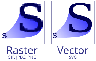
Vector graphics is a form of computer graphics in which visual images are created directly from geometric shapes defined on a Cartesian plane, such as points, lines, curves and polygons. The associated mechanisms may include vector display and printing hardware, vector data models and file formats, as well as the software based on these data models. Vector graphics is an alternative to raster or bitmap graphics, with each having advantages and disadvantages in specific situations.
MIL-STD-188 is a series of U.S. military standards relating to telecommunications.
A signal generator is one of a class of electronic devices that generates electrical signals with set properties of amplitude, frequency, and wave shape. These generated signals are used as a stimulus for electronic measurements, typically used in designing, testing, troubleshooting, and repairing electronic or electroacoustic devices, though it often has artistic uses as well.
A raster graphics editor is a computer program that allows users to create and edit images interactively on the computer screen and save them in one of many raster graphics file formats such as JPEG, PNG, and GIF.
Esri is an American multinational geographic information system (GIS) software company. It is best known for its ArcGIS products. With a 43% market share, Esri is the world's leading supplier of GIS software, web GIS and geodatabase management applications. The company is headquartered in Redlands, California.
Aldus Corporation was an American software company best known for its pioneering desktop publishing (DTP) software. PageMaker, the company's most well-known product, ushered in the modern era of desktop computers such as the Macintosh seeing widespread use in the publishing industry. Paul Brainerd, the company's co-founder, coined the term desktop publishing to describe this paradigm. The company also originated the Tag Image File Format (TIFF) file format, widely used in the digital graphics profession.
Adobe Illustrator is a vector graphics editor and design program developed and marketed by Adobe Inc. Originally designed for the Apple Macintosh, development of Adobe Illustrator began in 1985. Along with Creative Cloud, Illustrator CC was released. The latest version, Illustrator 2023, was released on October 18, 2022, and is the 27th generation in the product line. Adobe Illustrator was reviewed as the best vector graphics editing program in 2021 by PC Magazine.
H.261 is an ITU-T video compression standard, first ratified in November 1988. It is the first member of the H.26x family of video coding standards in the domain of the ITU-T Study Group 16 Video Coding Experts Group. It was the first video coding standard that was useful in practical terms.
A GIS file format is a standard for encoding geographical information into a computer file, as a specialized type of file format for use in geographic information systems (GIS) and other geospatial applications. Since the 1970s, dozens of formats have been created based on various data models for various purposes. They have been created by government mapping agencies, GIS software vendors, standards bodies such as the Open Geospatial Consortium, informal user communities, and even individual developers.
A document file format is a text or binary file format for storing documents on a storage media, especially for use by computers. There currently exist a multitude of incompatible document file formats.
A digital image is an image composed of picture elements, also known as pixels, each with finite, discrete quantities of numeric representation for its intensity or gray level that is an output from its two-dimensional functions fed as input by its spatial coordinates denoted with x, y on the x-axis and y-axis, respectively. Depending on whether the image resolution is fixed, it may be of vector or raster type. By itself, the term "digital image" usually refers to raster images or bitmapped images.
Prepress is the term used in the printing and publishing industries for the processes and procedures that occur between the creation of a print layout and the final printing. The prepress process includes the preparation of artwork for press, media selection, proofing, quality control checks and the production of printing plates if required. The artwork is often provided by the customer as a print-ready PDF file created in desktop publishing.

The Gerber format is an open, ASCII, vector format for printed circuit board (PCB) designs. It is the de facto standard used by PCB industry software to describe the printed circuit board images: copper layers, solder mask, legend, drill data, etc.
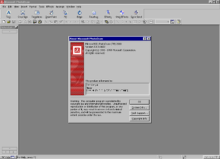
Microsoft PhotoDraw 2000 is a discontinued vector graphics and raster imaging software package developed by Microsoft.
The National Imagery Transmission Format Standard (NITFS) is a U.S. Department of Defense (DoD) and Federal Intelligence Community (IC) suite of standards for the exchange, storage, and transmission of digital-imagery products and image-related products.
A number of vector graphics editors exist for various platforms. Potential users of these editors will make a comparison of vector graphics editors based on factors such as the availability for the user's platform, the software license, the feature set, the merits of the user interface (UI) and the focus of the program. Some programs are more suitable for artistic work while others are better for technical drawings. Another important factor is the application's support of various vector and bitmap image formats for import and export.
An image file format is a file format for a digital image. There are many formats that can be used, such as JPEG, PNG, and GIF. Most formats up until 2022 were for storing 2D images, not 3D ones. The data stored in an image file format may be compressed or uncompressed. If the data is compressed, it may be done so using lossy compression or lossless compression. For graphic design applications, vector formats are often used. Some image file formats support transparency.

The Vector Map (VMAP), also called Vector Smart Map, is a vector-based collection of geographic information system (GIS) data about Earth at various levels of detail. Level 0 (low resolution) coverage is global and entirely in the public domain. Level 1 (global coverage at medium resolution) is only partly in the public domain.
VPF can refer to:
Doremi Laboratories, Inc., often shortened to Doremi Labs, was a developer and manufacturer of digital servers and format converters for the digital cinema, broadcast, post-production and professional A/V markets. It was established in 1985 in Burbank, California, United States, and was absorbed into Dolby Laboratories in a 2014 acquisition.