
Republika Srpska, is one of two entities of Bosnia and Herzegovina, the other being the Federation of Bosnia and Herzegovina. Its largest city and administrative centre is Banja Luka, lying on the Vrbas river.

The Herzegovina-Neretva Canton is one of 10 cantons of the Federation of Bosnia and Herzegovina in Bosnia and Herzegovina.
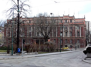
Centar is a municipality of the city of Sarajevo, Bosnia and Herzegovina. It is located between the older parts of the city under Stari Grad, and the newer more modern parts of the city under the municipalities Novi Grad and Novo Sarajevo.
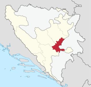
The Sarajevo Canton, officially the Canton of Sarajevo is one of 10 cantons of the Federation of Bosnia and Herzegovina in Bosnia and Herzegovina. Its cantonal seat is the city of Sarajevo, also the capital city of Bosnia and Herzegovina.

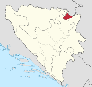
Zavidovići is a town and municipality located in Zenica-Doboj Canton of the Federation of Bosnia and Herzegovina, an entity of Bosnia and Herzegovina. It is situated in central Bosnia and Herzegovina, located between Doboj and Zenica on the confluence of rivers Bosna, Krivaja and Gostović. It sits in a valley surrounded by many mountains of which the largest is Klek. As of 2013, it has a population of 40,272 inhabitants.

Šamac is a town and municipality located in the northeastern part of the Republika Srpska, an entity of Bosnia and Herzegovina. As of 2013, the town has a population of 5,390 inhabitants, while the municipality has 17,273 inhabitants. It is situated on the right bank of the Sava river. Across the river is Slavonski Šamac in Croatia.
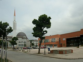
Ilijaš is a town and municipality located in Sarajevo Canton of the Federation of Bosnia and Herzegovina, an entity of Bosnia and Herzegovina. It is located north-east of the inner city of Sarajevo and was established in May 1952 with the organization of people's committees. Those local people's committees founded the local municipalities, which led to self-management of the municipalities, including the municipality of Ilijaš.
The SAO of Bosanska Krajina was a self-proclaimed Serbian Autonomous Oblast within today's Bosnia and Herzegovina. It was sometimes called the Autonomous Oblast of Krajina, or the Autonomous Region of Krajina (ARK). SAO Bosanska Krajina was located in the geographical region named Bosanska Krajina. Its capital was Banja Luka. The region was subsequently included into Republika Srpska.
The SAO of Herzegovina was a self-proclaimed Serbian Autonomous Oblast within today's Bosnia and Herzegovina. It was proclaimed by the Assembly of the Association of Municipalities of Bosnian Krajina in 1991 and was subsequently included into Republika Srpska. SAO Herzegovina was located in the geographical region of Herzegovina. It was also known as SAO Eastern Herzegovina.

Novi Travnik is a town and municipality located in Central Bosnia Canton of the Federation of Bosnia and Herzegovina, an entity of Bosnia and Herzegovina. As of 2013, it has a population of 25,107 inhabitants.

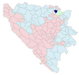
Teočak is a town and municipality located in Tuzla Canton of the Federation of Bosnia and Herzegovina, an entity of Bosnia and Herzegovina.
Brčko District, officially the Brčko District of Bosnia and Herzegovina, is a self-governing administrative unit in north-eastern Bosnia and Herzegovina.

This article is about the Demographic history of Bosnia and Herzegovina, and deals with the country's documented demographics over time. For an overview of the various ethnic groups and their historical development, see Ethnic groups in Bosnia and Herzegovina.

Čajniče is a town and municipality located in Republika Srpska, an entity of Bosnia and Herzegovina. As of 2013, the town has a population of 2,401 inhabitants, while the municipality has 4,895 inhabitants.

Maglaj is a town and municipality located in Zenica-Doboj Canton of the Federation of Bosnia and Herzegovina, an entity of Bosnia and Herzegovina. It is located in northern Bosnia and Herzegovina, 25 km (16 mi) south of Doboj. It has a population of 24,980 inhabitants.

Domaljevac-Šamac is a municipality located in Posavina Canton of the Federation of Bosnia and Herzegovina, an entity of Bosnia and Herzegovina.
Pelagićevo is a town and municipality located in Republika Srpska, an entity of Bosnia and Herzegovina. It is located in the Posavina geographical region. As of 2013, the town has a population of 2,796 inhabitants, while the municipality has 5,220 inhabitants.
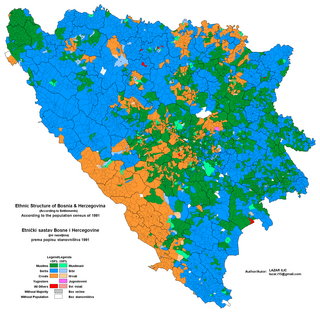
The 1991 population census in Bosnia and Herzegovina was the last census of the population undertaken in the Socialist Republic of Bosnia and Herzegovina before the Bosnian War. It was conducted during the final week of March 1991. For the 1991 census there were 109 municipalities of which ten were part of Sarajevo.

Herzegovina is the southern region of Bosnia and Herzegovina. It never had strictly defined geographical or cultural borders and it is not an administrative division in modern Bosnia and Herzegovina. It is generally taken to border larger Bosnia to the north, Dalmatia to the southwest and Montenegro to the southeast. Measurements of the area range widely from c. 11,500 km2 (4,400 sq mi), or around 23% of the total area of the present-day country, to c. 12,300 km2 (4,700 sq mi), around 25% of the country.
From August 1990 to November 1991, during the breakup of Yugoslavia, several Serb Autonomous Regions, or Districts were proclaimed in the Yugoslav republics of SR Croatia and SR Bosnia and Herzegovina in light of the possible secession of the republics from the Socialist Federal Republic of Yugoslavia. These were autonomous Serb-inhabited entities that subsequently united in their respective republic to form the Republic of Serbian Krajina in Croatia and the Republika Srpska in Bosnia and Herzegovina.
