Notes
![]() This article incorporates text by R. Talbert, Sean Gillies, Tom Elliott, Jeffrey Becker available under the CC BY 1.0 license.
This article incorporates text by R. Talbert, Sean Gillies, Tom Elliott, Jeffrey Becker available under the CC BY 1.0 license.
- ↑ Pliny NH III 3,69.
The Venetulani are among the 53 peoples of Latium Vetus that Pliny the Elder records as having perished without leaving a trace (interiere sine vestigiis). They are counted among the 30 Alban communities that carried out and participated in sacrificial activities on Mons Albanus. The name is believed to derive from a Veneti settlement, which may have been called Venetulum. [1]
![]() This article incorporates text by R. Talbert, Sean Gillies, Tom Elliott, Jeffrey Becker available under the CC BY 1.0 license.
This article incorporates text by R. Talbert, Sean Gillies, Tom Elliott, Jeffrey Becker available under the CC BY 1.0 license.
{{cite web}}: CS1 maint: multiple names: authors list (link)| Authority control databases: Geographic |
|---|

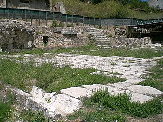
Lanuvium, modern Lanuvio, is an ancient city of Latium vetus, some 32 kilometres (20 mi) southeast of Rome, a little southwest of the Via Appia.
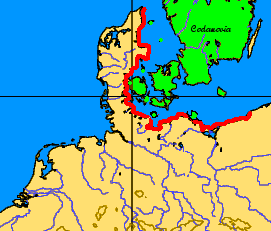
The Codanus sinus is the Latin name of the Baltic Sea and Kattegat.
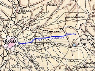
Collatia was an ancient town of central Italy, c. 15 km northeast of Rome by the Via Collatina.

Alsium was an ancient city on the coast of Etruria, between Pyrgi and Fregenae, on the Via Aurelia, by which it is about 35 km from Rome near the modern Ladispoli. It was one of the oldest towns of Etruria, but does not appear in history until the Roman colonisation of 247 BC. It was never of great importance, except as a resort of wealthy Romans, many of whom had villas there.

Aquae Cutiliae is an ancient Roman site situated on mineral springs known today as Terme di Cotilia or Terme di Vespasiano, near the modern Cittaducale, 9 miles east of Rieti in the Sabina region.

Crustumerium was an ancient town of Latium, on the edge of the Sabine territory, near the headwaters of the Allia, not far from the Tiber.
Compsa was an ancient city of the Hirpini, near the sources of the Aufidus, on the boundary of Lucania and not far from that of Apulia, on a ridge 609 m above sea level. It was betrayed to Hannibal in 216 BC after the defeat of Cannae, but recaptured two years later. It was probably occupied by Sulla in 89 BC, and was the scene of the death of Titus Annius Milo in 48 BC.
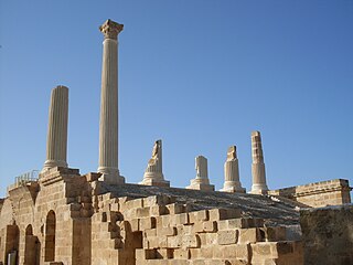
Uthina or Oudna was an ancient Roman-Berber city located near Tunis, Tunisia.

Atarneus, also known as Atarna (Ἄταρνα) and Atarneites (Ἀταρνείτης), was an ancient Greek city in the region of Aeolis, Asia Minor. It lies on the mainland opposite the island of Lesbos. It was on the road from Adramyttium to the plain of the Caicus. Its territory was called the Atarneitis.
Ad Turres Albas was an ancient city of Latium. Ad Turres Albas originally belonged to the Volsci, and stood on the coast and on the Via Severiana, 9 miles from Circeii and 9 miles from Astura. The location of Ad Turres Albas is not precisely known: the editors of the Barrington Atlas of the Greek and Roman World place it at near the modern Lago di Caprolace in the Province of Latina, Lazio, Italy.

Helorus, Heloros, Helorum, or Elorus, was an ancient Greek city of Magna Graecia in Sicily, situated near the east coast, about 40 km south of Syracuse and on the banks of the river of the same name. It is currently an archaeological site in the modern comune of Noto.

The Francolí is a river in Catalonia. Its source is in the Prades Mountains and it flows into the Mediterranean Sea at Tarragona.

Saxa Rubra was a village and station on the Roman Flaminian Way, 9 miles (14 km) from Rome, Italy.

Alyzeia or Alyzia (Ἀλυζια), was a town on the west coast of ancient Acarnania. According to Strabo it was distant 15 stadia from the sea, on which it possessed a harbour and a sanctuary, both dedicated to Heracles. In this sanctuary were some works of art by Lysippus, representing the Labours of Heracles, which a Roman general caused to be removed to Rome on account of the deserted state of the place. The remains of Alyzia are still visible in the valley of Kandila. The distance of the bay of Kandila from the ruins to Leucas corresponds with the 120 stadia which Cicero assigns for the distance between Alyzia and Leucas. Alyzia is said to have derived its name from Alyzeus, a son of Icarius. It is first mentioned by Thucydides; in 375 BCE, a naval battle was fought in the neighbourhood of Alyzia between the Athenians under Timotheus and the Lacedaemonians under Nicolochus. The Athenians, says Xenophon, erected their trophy at Alyzia, and the Lacedaemonians in the nearest islands. We learn from the Periplus of Pseudo-Scylax that the island immediately opposite Alyzia was called Carnus, the modern Kalamos.
Tyrodiza was a Greek city in ancient Thrace, located in the region of the Propontis. It appears to have flourished between 550 BCE and 330 BCE, and is identified with the place called Tiristasis in the Periplus of Pseudo-Scylax and Pliny the Elder. It was a member of the Delian League and appears in the tribute lists of ancient Athens between 452/1 and 445/4 BCE. In 340 BCE, Tiristasis was taken by the Athenian general Diopeithes, who enslaved its inhabitants along with those of Crobyle.
The Namnetes were a Gallic tribe dwelling near the modern city of Nantes during the Iron Age and the Roman period.
Old Latium is a region of the Apennine Peninsula bounded to the north by the Tiber River, to the east by the central Apennine Mountains, to the west by the Mediterranean Sea and to the south by Monte Circeo. It was the territory of the Latins, an Italic tribe which included the early inhabitants of the city of Rome. Later it was also settled by various Italic tribes such as the Rutulians, Volscians, Aequi, and Hernici. The region was referred to as "old" to distinguish it from the expanded region, Latium, that included the region to the south of Old Latium, between Monte Circeo and the river Garigliano – the so-called Latium adiectum. It corresponded to the central part of the modern administrative region of Lazio, Italy, and it covered an area measuring of roughly 50 Roman miles. It was calculated by Mommsen that the region's area was about 1860 square kilometres.
Valvisciolo is a historical location in Latium, Italy, close to Sermoneta and Latina. Known mainly for the Valvisciolo Abbey, this locality also includes important archaeological remains of a prehistoric, hillside settlement at the Valvisciolo/Caracupa site. The site is a terraced settlement utilizing megalithic architecture, perhaps in technical terms an early predecessor of the more developed polygonal masonry of the later first millennium BC. Occupation on the site ends in the sixth century BC, with local populations perhaps shifting to the Latin city of Norba which was incorporated as a Latin colonia by 492 BCE, according to the textual tradition, mainly based on the historian Livy.
Hacıveliler is a neighbourhood in the municipality and district of Kumluca, Antalya Province, Turkey. Its population is 2,376 (2022).