
Rauma is a municipality in Møre og Romsdal county, Norway. It is part of the traditional district of Romsdal. The administrative centre is the town of Åndalsnes. Other settlements in Rauma include the villages of Vågstranda, Måndalen, Innfjorden, Veblungsnes, Verma, Isfjorden, Eidsbygda, Rødven, Åfarnes, and Mittet. Most settlement in the municipality is located along the fjords and in the Romsdalen valley.
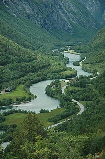
The Rauma is a river that runs through Romsdalen, a valley in Møre og Romsdal and Oppland counties in Norway. It runs for 68 kilometres (42 mi) from Lesjaskogsvatnet, a lake in the municipality of Lesja, to the town of Åndalsnes in the municipality of Rauma. The river was once famous for its salmon-fishing, but since an infection with Gyrodactylus salaris only 5 to 10% of the original stock survives. The salmon runs up to the Slettafossen, a 16-metre (52 ft) high combination of waterfalls and rapids more than 42 kilometres (26 mi) upriver from the estuary.

Romsdal is the name of a traditional district in the Norwegian county Møre og Romsdal, located between Nordmøre and Sunnmøre. The district of Romsdal comprises Aukra, Fræna, Midsund, Molde, Nesset, Rauma, Sandøy, and Vestnes. It is named after the valley of Romsdalen, which covers part of Rauma.

The Rauma Line is a 114.2 kilometres (71.0 mi) long railway between the town of Åndalsnes, and the village of Dombås, in Norway. Running down the Romsdalen valley, the line opened between 1921 and 1924 as a branch of the Dovre Line, which connects to the cities of Oslo and Trondheim. Originally intended as the first stage to connect Ålesund, and possibly also Molde and Kristiansund, no extensions have ever been realized. The unelectrified line is served four times daily with Norwegian State Railways' Class 93, although in the summer the service only operates from Åndalsnes to Bjorli as a tourist service. CargoLink operates a daily freight train.

Åndalsnes (help·info) is a town in Rauma Municipality in Møre og Romsdal county, Norway. Åndalsnes is the administrative center of Rauma Municipality. The 2.22-square-kilometre (550-acre) town has a population (2013) of 2,244, giving it a population density of 1,011 inhabitants per square kilometre (2,620/sq mi). The village of Isfjorden lies about 7 kilometres (4.3 mi) to the east, Veblungsnes lies just to the west across the Rauma River, and Innfjorden lies about 10 kilometres (6.2 mi) to the southwest via the European Route E136 highway.

Lesjaskogsvatnet is a lake in Lesja, Norway.

The Kylling Bridge is a railway bridge in Rauma Municipality in Møre og Romsdal county, Norway. The bridge crosses the Rauma River near the village of Verma in the upper part of the Romsdalen valley. The bridge is part of a double horseshoe curve that allows the railway to pass a narrow and steep section of the valley. It is one of the most photographed railway bridges in Norway. The Kylling Bridge is 76 metres (249 ft) long. The main span is 42 metres (138 ft), and side spans are 10 metres (33 ft) and 8 metres (26 ft). The clearance to the river below is 59.3 metres (195 ft).

Romsdalsfjord or Romsdal Fjord is the ninth-longest fjord in Norway. It is 88 kilometres (55 mi) long and located in the Romsdal district of Møre og Romsdal county. It flows through the municipalities of Midsund, Haram, Vestnes, Molde, Nesset, and Rauma. The deepest point in the fjord is just southwest of the town of Molde, where it is 550 metres (1,800 ft) deep. Romsdalsfjord is a threshold-fjord, as it is separated from the ocean by shallower areas at the mouth. Several islands and skerries also shelter the wide central fjord from the Atlantic.
Eid is a former municipality in Møre og Romsdal county, Norway. It was located in the north-central part of the present-day Rauma Municipality. The municipality was only 36 square kilometres (14 sq mi), along the Romsdalsfjorden. The municipality included the village area of Eidsbygda and extended to the southeast to the coast of the Isfjorden.
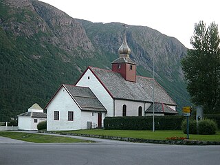
Hen is a former municipality in Møre og Romsdal county, Norway. The 245-square-kilometre (95 sq mi) municipality existed from 1902 until 1964, and it encompassed the valleys extending to the south and east of the Isfjorden in the northeastern part of the present-day Rauma Municipality. The administrative center of Hen was the village of Isfjorden. The area of Hen Municipality is still a parish within the municipality of Rauma. The parish has one church, Hen Church, located in Isfjorden.
Mittet is a small village in the northern part of Rauma Municipality in Møre og Romsdal county, Norway. It is located on the south shore of the Langfjorden. Mittet has a population of about 150. It has a grocery store, gas station, and a camping site. Holm Church is located about 7 kilometres (4.3 mi) to the west of the village.

Trollryggen is a peak along the Trolltindene ridge along the Romsdalen valley. It is located in Rauma Municipality in Møre og Romsdal county, Norway. The Rauma River and the European route E136 highway lie just to the east of the ridge at the bottom of the valley.

Åndalsnes Station is a railway station in the town of Åndalsnes, the administrative centre of Rauma Municipality in Møre og Romsdal county, Norway. It has been the terminal station of the Rauma Line since the line was extended to Åndalsnes on 30 November 1924. The station was designed by Gudmund Hoel and is located on reclaimed land along the Isfjorden. To get the line to the station, a cutting had to be built. In addition to a station building, the station has an engine shed and a bus station; the station building is next to a cruise ship port. It serves four passenger trains per day, and has correspondence by bus onwards to the nearby towns of Molde and Ålesund. The station is manned and features a chapel within a retired train carriage.
Vågstranda is a village along Romsdal Fjord in Rauma Municipality in Møre og Romsdal county, Norway. It is located along the European route E136 highway, about 10 kilometres (6.2 mi) north of the village of Voll and 11 kilometres (6.8 mi) east of the village of Vikebukt. Vågstranda Church, built in 1870, is located in the village.

Veblungsnes is a village located in Rauma Municipality in Møre og Romsdal county, Norway. The village lies along Romsdal Fjord just across the mouth of the Rauma River from the town of Åndalsnes. The European route E136 highway runs through the village on its way from Åndalsnes southwest to the village of Innfjorden. Veblungsnes is home to the Grytten Church and the Setnesmoen parade ground.

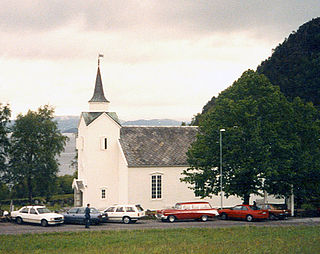
Grytten Church is a parish church in Rauma Municipality in Møre og Romsdal county, Norway. It is located near the mouth of the Rauma River in the village of Veblungsnes. The church is part of the Grytten parish in the Indre Romsdal deanery in the Diocese of Møre. The red, wooden, octagonal church was built in 1829 possibly using Sør-Fron Church as a model. The church seats about 250 people. Four large columns support the tower. In the church there is a tall wooden crucifix, possibly from the 13th century. The church has so called pulpit altar, that is the pulpit is centrally located directly above the altar. The two churchbells are from the previous churches.
Måndalen is a village in Rauma Municipality in Møre og Romsdal county, Norway. The village is located along the Romsdalsfjorden about 20 kilometres (12 mi) west of the town of Åndalsnes. The European route E136 highway goes through Voll, connecting it to the village of Vågstranda [10 kilometres (6.2 mi) to the north] and the village of Innfjorden [10 kilometres (6.2 mi) to the southeast].

Vermafossen or Vermefossen is a waterfall in the Verma tributary to Rauma near Verma village. Verma flows in steep cascades, splits in three canals and finally drops 50 meters into the main river. The total height is about 380 meters along 1000 meters of the Verma river. In the world waterfall database it is listed as the 242nd tallest in the world. The valley of the Verma river is a typical "hook-valley" (agnordal) as Verma river in prehistory was a tributary to Gudbrandsdalslågen to the east. As the Rauma river gradually dug into the bedrock in upper Romsdalen valley the watershed shifted east and Verma river was captured by Rauma river. Hans Reusch described this peculiarity of the Scandinavian divide in 1905. The hook-valley phenomenon is particularly visible around the Romsdalen/Eikesdalen and northern Gudbrandsdalen.


