
Victoria Island is a large island in the Canadian Arctic Archipelago that straddles the boundary between Nunavut and the Northwest Territories of Canada. It is the eighth largest island in the world, and at 217,291 km2 (83,897 sq mi) in area, it is Canada's second largest island. It is nearly double the size of Newfoundland (111,390 km2 [43,008 sq mi]), and is slightly larger than the island of Great Britain (209,331 km2 [80,823 sq mi]) but smaller than Honshu (225,800 km2 [87,182 sq mi]). It contains the world's largest island within an island within an island. The western third of the island belongs to the Inuvik Region in the Northwest Territories; the remainder is part of Nunavut's Kitikmeot Region.

The Arctic Archipelago, also known as the Canadian Arctic Archipelago, is a group of islands north of the Canadian mainland.

Upper Hartfield is a small village slightly west of Hartfield in East Sussex, England. The Tudor house "Apedroc" in Upper Hartfield is the former home of Sir Michael Balcon. More recently the house was owned by the musician Alan Parsons.

The Balearic Sea is a body of water in the Mediterranean Sea near the Balearic Islands. It is not to be confused with the Alboran Sea or the Iberian shelf waters. The Ebro River flows into this small sea.

Střešovice is a neighborhood of green, quiet, village-like streets in the west of Prague. It is located in the Prague 6 district. Střešovice is often called the "local Beverly Hills" because it is home to some famous residents, including former President Václav Havel. The neighborhood is a 10-minute walk from Prague Castle, and the Dejvice district. There is also a large military hospital. The major sights include Villa Müller by functionalist architect Adolf Loos (1930) and The Church of St Norbert in Romanesque Revival (1890-1891) style.

Pozba is a village and municipality in the Nové Zámky District in the Nitra Region of south-west Slovakia.

Tahirpur is an upazila of Sunamganj District in the division of Sylhet, Bangladesh.

Belabo is an Upazila of Narsingdi District in the Division of Dhaka, Bangladesh. Here the 2,500-year-old civilisation of Wari Bateshwari has been discovered. It is believed that it was a port city with foreign trade with Rome, Southeast Asia and other regions. It is the oldest city so far discovered after Indus valley civilisation.

Kolhumadulu Atoll is an administrative division of the Maldives. It corresponds to the natural atoll of the same name. The ancient name of the island was Kolhumaduva during the time of King Koimala who united all atolls of the Maldives under one kingdom for the first time.
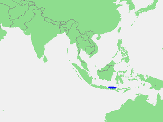
The Bali Sea is the body of water north of the island of Bali and south of Kangean Island in Indonesia. The sea forms the south-west part of the Flores Sea, and the Madura Strait opens into it from the west.
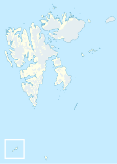
Bölscheøya is an island southwest of Negerpynten, the southeastern point of Edgeøya. It is part of Thousand Islands. The island was named in 1868 by the German geographer August Petermann (1822–78) after the German journalist Carl Bölsche, father of the German writer and zoologist Wilhelm Bölsche (1843–93). The remains of a whaling station from the 17th century can be found on the island.

Barzykowo is a village in the administrative district of Gmina Stawiski, within Kolno County, Podlaskie Voivodeship, in north-eastern Poland. It lies approximately 5 kilometres (3 mi) north-west of Stawiski, 13 km (8 mi) east of Kolno, and 77 km (48 mi) north-west of the regional capital Białystok.

Broszków is a village in the administrative district of Gmina Kotuń, within Siedlce County, Masovian Voivodeship, in east-central Poland. It lies approximately 4 kilometres (2 mi) north-east of Kotuń, 12 km (7 mi) west of Siedlce, and 77 km (48 mi) east of Warsaw.
The Findlay Group is a group of islands in the Canadian Arctic Archipelago in Qikiqtaaluk Region, Nunavut. This Arctic Ocean group consists of Lougheed Island, Stupart Island, Edmund Walker Island, Grosvenor Island and Patterson Island.

The Xhemahallë Complex is a Cultural Monument of Albania, located in Delvinë. The mosque of the complex is thought to be the very first "King type" mosque in Albania.
Barbarušince is a village in the municipality of Vranje, Serbia. According to the 2002 census, the village has a population of 86 people.
Darkoti State was one of the Princely states of India during the period of the British Raj. Its last ruler signed the accession to the Dominion of India on 15 April 1948. Currently, it is part of the Indian state of Himachal Pradesh.

Esrum Å is the principal drainage of Lake Esrum, Denmark's second largest lake, located in Gribskov Municipality, some 50 km north of Copenhagen, Denmark. The 10-km-long stream extends from the northwestern part of the lake and flows past Esrum Watermill and Esrum Abbey on its way to The Kattegat at Dronningmølle.
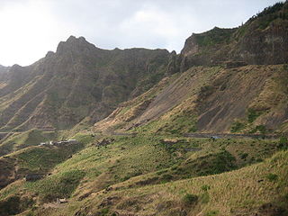
EN1-ST01 is a first class national road on the island of Santiago, Cape Verde. It runs from the capital Praia in the south to Tarrafal in the north, through the mountainous interior of the island. It is 61 km long. The main intersections are:


