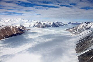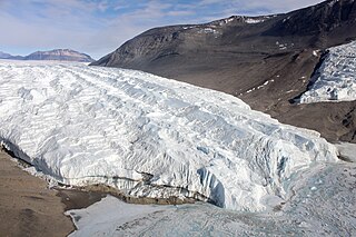
Ferrar Glacier is a glacier in Antarctica. It is about 35 nautical miles long, flowing from the plateau of Victoria Land west of the Royal Society Range to New Harbour in McMurdo Sound. The glacier makes a right (east) turn northeast of Knobhead, where it where it is apposed, i.e., joined in Siamese-twin fashion, to Taylor Glacier. From there, it continues east along the south side of Kukri Hills to New Harbor.

The Taylor Glacier is a glacier in Antarctica about 35 nautical miles long, flowing from the plateau of Victoria Land into the western end of Taylor Valley, north of the Kukri Hills. It flows to the south of the Asgard Range. The middle part of the glacier is bounded on the north by the Inland Forts and on the south by Beacon Valley.
Beaver Glacier is a glacier about 15 miles (24 km) long and 4 miles (6 km) wide, flowing west into Amundsen Bay between Auster Glacier and Mount Gleadell. The head of Beaver Glacier is located very close to the base of Mount King in Enderby Land. It was visited by an Australian National Antarctic Research Expeditions (ANARE) party on October 28, 1956, and named after the Beaver aircraft used by ANARE in coastal exploration.

Wahlenbergfjorden, sometimes known in English as Waalenburg Bay, is a fjord on the southwest coast of the Arctic island of Nordaustlandet, in Norway's Svalbard archipelago. At 46 kilometres (29 mi) in length, and 15 km (9.3 mi) wide, it is the fifth longest fjord in the archipelago, and the longest on the island. The fjord separates Gustav V Land in the north from Gustav Adolf Land in the south, at geographical co-ordinates 79°40′N20°00′E. Its mouth faces Spitsbergen across Hinlopen Strait, the strait separating the two islands.

Hooker Island is one of the central islands of Franz Josef Land. It is located in the central area of the archipelago at 80.23°N 53.02°E. It is administered by the Arkhangelsk Oblast, Russia.

Akseløya is a long, narrow island at the mouth of Van Mijenfjorden, separating Van Mijenfjorden from Bellsund. It is separated from the mainland by Akselsundet to the north, and another narrow strait to the south. The islands are named after the schooner Aksel Thordsen, which was chartered by Adolf Erik Nordenskiöld for an expedition to Svalbard in 1864.
Seip mountain or Seipefjellet in Svalbard is a mountain with the peaks 720 and 710 masl, between Orustdalen, Vestre Grønnfjordbreen and Dahlfonna, west in Nordenskiöld Land. Ascended by A. Koller and assistants of the Hoel and Staxrud expedition, on July 16, 1911, for geographical surveying. Named after Karl Seip, 1850–1909, Norwegian clergyman, educationalist and politician, minister for church affairs and education 1908–09, in which capacity he proposed a government grant for Isachsen's Spitsbergen expedition 1909-10

Wedel Jarlsberg Land is the land area between Van Keulenfjorden and Hornsund on the southwestern part of Spitsbergen, Svalbard. The area is largely covered with glaciers, and is completely within the Sør-Spitsbergen National Park.

Torell Land is a land area at the southeast part of Spitsbergen, Svalbard. It is named after Otto Martin Torell. Two glaciers, Hornbreen and Hambergbreen, divide Torell Land from Sørkapp Land.

Heer Land is a land area on the east coast of Spitsbergen, Svalbard. It is bordered by Rindersbukta to the southwest, Braganzavågen and Kjellströmdalen to the northwest, Storfjorden to the east and southeast, and Torell Land to the south. It is named after paleobotanist Oswald Heer. Heer Land mainly consist of glaciers and nunataks.

Stanisław Baranowski Spitsbergen Polar Station or Stanisław Baranowski Glaciologjcal Station is a research station near the Werenskiold Glacier on Spitsbergen, the largest island of the Svalbard archipelago in Norway. It is operated by the Institute of Geography and Regional Development of the Polish University of Wrocław.

Torellbreen is a glacier in Wedel Jarlsberg Land at Spitsbergen, Svalbard. It forms a front below the mountain Raudfjellet, with a length of about twenty kilometers, and is a merge of the two glaciers Austre Torellbreen and Vestre Torellbreen. The glacier is named after Swedish scientist Otto Martin Torell.
Antoniabreen is a glacier in Wedel Jarlsberg Land at Spitsbergen, Svalbard. The glacier has a length of about twelve kilometers and a width of two kilometers, and is located east of Martinfjella. The glacier is named after Maria Antonia of Parma.
Ramondbreen is a glacier in Wedel Jarlsberg Land at Spitsbergen, Svalbard. The glacier has a length of about two kilometers, and is part of the Recherchebreen glacier complex. It is named after Arctic explorer Gontaud Ramond.
Dollfusbreen is a glacier in Wedel Jarlsberg Land at Spitsbergen, Svalbard. The glacier has a length of about 1.5 kilometers, is part of the Recherchebreen glacier complex, and is located between Steinegga and Gaimardtoppen. It is named after Arctic explorer Gustav F. Dollfus.

Anchialus Glacier is the 8.5 km long and 3.4 km wide glacier in Sostra Heights on the east side of northern Sentinel Range in Ellsworth Mountains, Antarctica. It is situated north of lower Embree Glacier, east of Sabazios Glacier, south of lower Newcomer Glacier and northwest of Vit Ice Piedmont. The glacier drains the northeast slopes of Mount Malone and the west slopes of Bracken Peak, flows northwards and joins Newcomer Glacier east of Mount Lanning.
Qvigstadfjellet is a mountain in Nordenskiöld Land at Spitsbergen, Svalbard. It is named after Norwegian philologist and politician Just Knud Qvigstad. The mountain reaches a height of 770 m.a.s.l. It is located between the valley of Orustdalen and the glacier of Vestre Grønfjordbreen, south of Aldegondabreen.
Aldegondabreen is a glacier in Nordenskiöld Land at Spitsbergen, Svalbard, Norway. It is named after Infanta Adelgundes, Duchess of Guimarães. The glacier has a length of about 5.5 kilometers. It flows from Qvigstadfjellet, Christensenfjella and Hermod Petersenfjellet towards Grønfjorden.
Erdmannbreen is a glacier in Nordenskiöld Land at Spitsbergen, Svalbard. It is named after Swedish geologist Axel Joachim Erdmann. The glacier has a length of about six kilometers, and is surrounded by the mountains of Malmberget, Ytterdalsgubben and Kosterfjellet. The river of Ytterdalselva originates from Erdmannbreen and flows through the valley of Ytterdalen to the bay of Van Muydenbukta.
Törnbohmfjella is a mountain range in Nathorst Land at Spitsbergen, Svalbard. The range is named after the Swedish geologist Alfred Elis Törnebohm. It covers an area about nine kilometers long and six kilometers wide, bordering on Van Keulenfjorden, Davisdalen, Martinbreen, Richterbreen and Richterdalen. Its highest mountain peak is Såta, and it also comprises Pallfjellet, Kolthoffberget, Ekholmfjellet and Venetzhumpen. The glaciers of Charpentierbreen and Venetzbreen are located within the mountain range of Törnbohmfjella.


