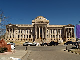
Pueblo County is one of the 64 counties in the U.S. state of Colorado. As of the 2010 census, the population was 159,063. The county seat is Pueblo. The county was named for the historic city of Pueblo which took its name from the Spanish language word meaning "town" or "village".

Cañon City is a Home Rule Municipality that is the county seat and the most populous municipality of Fremont County, Colorado, United States. The city population was 16,400 at the 2010 United States Census. Cañon City straddles the easterly flowing Arkansas River and is a popular tourist destination for sightseeing, whitewater rafting, and rock climbing. The city is known for its many public parks, fossil discoveries, Skyline Drive, The Royal Gorge railroad, the Royal Gorge, extensive natural hiking paths, and the tropical-like weather year-round."

The Korean War Veterans Memorial is located in Washington, D.C.'s West Potomac Park, southeast of the Lincoln Memorial and just south of the Reflecting Pool on the National Mall. It memorializes those who served in the Korean War.

The Texas State Capitol is the capitol building and seat of government of the American state of Texas. Located in downtown Austin, Texas, the structure houses the offices and chambers of the Texas Legislature and of the Governor of Texas. Designed in 1881 by architect Elijah E. Myers, it was constructed from 1882 to 1888 under the direction of civil engineer Reuben Lindsay Walker. A $75 million underground extension was completed in 1993. The building was added to the National Register of Historic Places in 1970 and recognized as a National Historic Landmark in 1986.

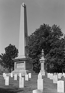
The Lincoln Tomb is the final resting place of the 16th President of the United States, Abraham Lincoln, his wife, Mary Todd Lincoln, and three of their four sons, Edward, William, and Thomas. It is located in Oak Ridge Cemetery in Springfield, Illinois. Constructed of granite, the tomb has a single-story rectangular base, surmounted by an obelisk, with a semicircular receiving room entrance-way, on one end, and semicircular crypt or burial room on the opposite side.

The Public Garden, also known as Boston Public Garden, is a large park in the heart of Boston, Massachusetts, adjacent to Boston Common. It is a part of the Emerald Necklace system of parks, and is bounded by Charles Street and Boston Common to the east, Beacon Street to the north, Arlington Street and Back Bay to the west, and Boylston Street to the south. The Public Garden was the first public botanical garden in America.
Salisbury National Cemetery is a United States National Cemetery located in the city of Salisbury, in Rowan County, North Carolina. Its first interments were Union soldiers who died at a Confederate prisoner of war camp at the site during the American Civil War. Administered by the United States Department of Veterans Affairs, it encompasses 65 acres (26 ha), 15 acres (6.1 ha) in the original location and 50 acres (20 ha) at the annex. As of 2012 it had 6500 interments, plus an estimated 3,800 in 18 mass graves, at the original location and 5000, in 4500 graves, in the new location.
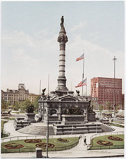
The Cuyahoga County Soldiers' and Sailors' Monument is a monument to Civil War soldiers and sailors from Cuyahoga County, Ohio. Located in the southeast quadrant of Public Square in downtown Cleveland, it opened July 4, 1894. It was designed by architect Levi Scofield (1842–1917), who also created the monument's sculptures. F.F. Schnitzer was the supervising architect who oversaw the creation of the structure. The monument is regularly open to the public free of charge.

The Veterans Memorial Bridge in Rochester, New York, carries New York State Route 104 across the Genesee River. The bridge is an architecturally significant concrete arch faced with white granite. Conceived in 1928 and finished in 1931, the span is the longest bridge in Rochester at 981 feet. It is 190 feet in height and 106 feet wide.
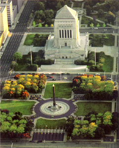
The Indiana World War Memorial Plaza is an urban feature located in Indianapolis, Indiana, United States, originally built to honor the veterans of World War I. The five-city-block plaza was conceived in 1919 as a location for the national headquarters of the American Legion and a memorial to the state's and nation's veterans. At the north end of the plaza is the American Legion Mall, which is the site of the administration buildings of the Legion, as well as a memorial cenotaph. South of that is the Veterans Memorial Plaza with its obelisk.

Pueblo Grande Ruin and Irrigation Sites are pre-Columbian archaeological sites and ruins, located in Phoenix, Arizona. They include a prehistoric platform mound and irrigation canals. The City of Phoenix manages these resources as the Pueblo Grande Museum Archaeological Park.

The Veterans Memorial Wall is located at 1145 East Adams Street, adjacent to the Jacksonville Municipal Stadium in downtown Jacksonville, Florida. The quarter-million dollar monument was dedicated in November, 1995 and serves as a tribute to more than 1,500 Jacksonville area American war heroes. The outdoor memorial was promoted as "the largest of its kind" and "the only wall that honors veterans from all six [service] branches" . The 65 foot-long black granite monument contains the names of servicemen and women from World War I through Operation Desert Storm and the current war on terrorism. In front of the wall stands a torch with an eternal flame.

The Jacksonville Riverwalks are a network of multi-use trails and open space developments along both the north and south banks of the St. Johns River in Jacksonville, Florida. The roughly 2-mile (3.2 km) Downtown Northbank portion travels alongside the Hyatt Regency Jacksonville, Jacksonville Landing, Times-Union Center for the Performing Arts, CSX Transportation Building, and extends into the Brooklyn district. The 1.25-mile (2.01 km) Southbank portion of the trail connects local landmarks such as Friendship Fountain, Museum of Science and History and Riverplace Tower.

The Steelworks Museum is located in Pueblo, Colorado. Operated by the Steelworks Center of the West, the museum is in the historic Minnequa Steel Works Office Building and Dispensary of the Colorado Fuel and Iron Company.
Located in Frankfort, Kentucky, overlooking the state capital, Kentucky Vietnam Veterans Memorial contains the name of 1,103 Kentuckians killed in the Vietnam War. The memorial is in the form of a sundial with the names placed so that the tip of the gnomon's shadow touches each man's name on the date of his death, thus giving each fallen warrior his own personal memorial day.

The Union Avenue Historic Commercial District is a century-old business district in Pueblo, Colorado, United States.The district comprises sixty-nine contributing properties in a total area of 27 acres (11 ha) including the Union Depot, Vail Hotel and Quaker Flour Mill. In 1983, the district was listed on the National Register of Historic Places. The historic district was originally located within South Pueblo and Central Pueblo, two small cities until incorporated into Pueblo, Colorado which combined South Pueblo, Central Pueblo, Pueblo and Bessemer into one municipality. While still South Pueblo, Bat Masterson, best known for his association with Wyatt Earp and Doc Holliday was brought in as sheriff to protect a railroad that was being built.

The Franklin D. Roosevelt Four Freedoms Park is a four-acre (1.6 ha) memorial to Franklin D. Roosevelt that celebrates the Four Freedoms he articulated in his 1941 State of the Union address. It is located adjacent to the historic Smallpox Hospital in New York City at the southernmost point of Roosevelt Island, in the East River between Manhattan Island and Queens. It was designed by the architect Louis Kahn.
Monument Creek is an El Paso County, Colorado stream on the Arkansas River water basin. It flows south from Mount Deception through Pikeview, Monument and into Colorado Springs, Colorado, where it meets up with Fountain Creek. It is 27.2 miles (43.8 km) from its northernmost boundary with National Forest Lands to its confluence with Fountain Creek near the intersection of Interstate 25 and U.S. Route 24.
El Pueblo is a neighborhood in Wichita, Kansas, United States. A mixed commercial and residential area on the east bank of the Little Arkansas River, it is the cultural and historical center of the city’s Hispanic community.