This article needs additional citations for verification .(December 2009) |
Victor Harbor High School (VHHS) is located in Victor Harbor, on the Fleurieu Peninsula in South Australia.
This article needs additional citations for verification .(December 2009) |
Victor Harbor High School (VHHS) is located in Victor Harbor, on the Fleurieu Peninsula in South Australia.
35°33′S138°37′E / 35.550°S 138.617°E
| | This article related to a school in South Australia is a stub. You can help Wikipedia by expanding it. |

The Java Sea is an extensive shallow sea on the Sunda Shelf, between the Indonesian islands of Borneo to the north, Java to the south, Sumatra to the west, and Sulawesi to the east. Karimata Strait to its northwest links it to the South China Sea. It is a part of the western Pacific Ocean.
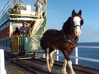
The Victor Harbor Horse Drawn Tram is located on the shores of the city of Victor Harbor, South Australia, Australia. A 3.1 km (1.9 mi) tramway links the city's visitor information centre with the nearby Granite Island. Much of its route is over a 630-metre (2,070-foot) causeway.
Tucker Glacier is a major valley glacier of Victoria Land, Antarctica, about 90 nautical miles long, flowing southeast between the Admiralty Mountains and the Victory Mountains to the Ross Sea. There is a snow saddle at the glacier's head, just west of Homerun Range, from which the Ebbe Glacier flows northwestward.

Granite Island, also known by the Ramindjeri people as Nulcoowarra, is a small island next to Victor Harbor, South Australia, about 80 km south of South Australia's capital city, Adelaide.
The Division of Mayo is an Australian electoral division located to the east and south of Adelaide, South Australia. Created in the state redistribution of 3 September 1984, the division is named after Helen Mayo, a social activist and the first woman elected to an Australian University Council. The 9,315 km2 rural seat covers an area from the Barossa Valley in the north to Cape Jervis in the south. Taking in the Adelaide Hills, Fleurieu Peninsula and Kangaroo Island regions, its largest population centre is Mount Barker. Its other population centres are Aldgate, Bridgewater, Littlehampton, McLaren Vale, Nairne, Stirling, Strathalbyn and Victor Harbor, and its smaller localities include American River, Ashbourne, Balhannah, Brukunga, Carrickalinga, Charleston, Cherry Gardens, Clarendon, Crafers, Cudlee Creek, Currency Creek, Delamere, Echunga, Forreston, Goolwa, Gumeracha, Hahndorf, Houghton, Inglewood, Kersbrook, Kingscote, Langhorne Creek, Lobethal, Macclesfield, McLaren Flat, Meadows, Middleton, Milang, Mount Compass, Mount Pleasant, Mount Torrens, Mylor, Myponga, Normanville, Norton Summit, Oakbank, Penneshaw, Piccadilly, Port Elliot, Second Valley, Springton, Summertown, Uraidla, Willunga, Woodchester, Woodside, Yankalilla, and parts of Birdwood, Old Noarlunga and Upper Sturt.

The Flores Sea covers 240,000 square kilometres (93,000 sq mi) of water in Indonesia. The sea is bounded on the north by the island of Celebes and on the south by the Sunda Islands of Flores and Sumbawa.
Northfield is a suburb of the greater Adelaide, South Australia area.

Sturt is a suburb of Adelaide in the City of Marion local government area. It was named after the explorer Captain Charles Sturt.

Ross Smith Secondary School was a high school in Northfield, South Australia. The original Northfield High School was opened in 1968. The School changed its name to the Ross Smith Secondary School in 1996 as a result of the amalgamation of Nailsworth and Northfield High Schools. The school had classes from Year 8 through to 12. The school's last principal was Judith O'Brien. The motto of the school was "Building a culture of success." The school was named after the aviator, Ross Macpherson Smith in part due to a large pine tree situated on the former oval of the school, thought to have been planted on the site where the Vickers Vimy came to a stop marking the end of the first flight from England to Australia. The tree has been retained and is now part of a small park.

Taylor Valley77°37′S163°00′E is an ice-free valley about 18 nautical miles long, once occupied by the receding Taylor Glacier. It lies north of the Kukri Hills between the Taylor Glacier and New Harbour in Victoria Land, Antarctica. Taylor Valley is the southernmost of the three large McMurdo Dry Valleys in the Transantarctic Mountains, located west of McMurdo Sound.
The City of Victor Harbor is a local government area of South Australia. It covers an area of 386.5 square kilometres (149.2 sq mi) along the coast, about 80 kilometres (50 mi) south of Adelaide, the capital of South Australia. The council is responsible for the town of Victor Harbor, which contains over 85% of its population, and the surrounding rural area to the north and west. The City of Victor Harbor had an estimated population of over 14,000 at the 2016 Census.

Granite Harbour is a bay in the coast of Victoria Land, Antarctica, about 14 nautical miles long, entered between Cape Archer and Cape Roberts. It was discovered and named by the British National Antarctic Expedition (BrNAE) of 1901–04 in the Discovery in January 1902, while searching for safe winter quarters for the ship. The name derives from the great granite boulders found on its shores.
The Tomilin Glacier is a glacier over 15 nautical miles long, draining north from Pope Mountain in the central Wilson Hills. It enters the sea east of Goodman Hills and Cape Kinsey, forming a substantial glacier tongue.
Greenhills Adventure Park was a theme park located near Victor Harbor, South Australia. It was established in 1982, and officially opened in March 1983 by Gavin Keneally, South Australia Minister for Tourism.
Kara Kara was an electoral district of the Legislative Assembly in the Australian state of Victoria from 1877 to 1927, and 1955 to 1976. It was based in north-western Victoria and included the subdivisions of Donald, Charlton, Minyip, Murtoa, St. Arnaud, Wedderburn, Inglewood, Dunnolly, Landsborough, Avoca, Maryborough and Carisbrook.
Encounter Bay was an electoral district of the House of Assembly in the Australian colony of South Australia from 1857 to 1902.

Wright Island is a 1 hectare island in Encounter Bay, South Australia. It is located between the popular tourist destination Granite Island and the prominent rocky headland known as The Bluff. The island consists largely of granite boulders. It also features low vegetation and a sandy beach suitable for the landing of small boats. The island is uninhabited and can only be accessed from the water. It was named after William Wright, one of the headmen of the South Australia Company's whaling operations in the Victor Harbor area in the 1800s. The island is managed by the City of Victor Harbor, the local government authority, as part of its parks and gardens asset.

The County of Hindmarsh is one of the 49 cadastral counties of South Australia. It was proclaimed by Governor George Grey in 1842 and named for Governor John Hindmarsh.