Related Research Articles
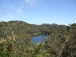
The Budj Bim National Park, formerly known as Mount Eccles National Park, is a national park located in the Western District of Victoria, Australia. The 5,470-hectare (13,500-acre) national park is situated approximately 270 kilometres (170 mi) west of Melbourne and approximately 15 kilometres (9.3 mi) southwest of Macarthur. It derives its name from the Budj Bim volcano, formerly Mount Eccles, which is situated in the north-east of the park.
The Kosciuszko National Park is a 6,900-square-kilometre (2,700 sq mi) national park and contains mainland Australia's highest peak, Mount Kosciuszko, for which it is named, and Cabramurra, the highest town in Australia. Its borders contain a mix of rugged mountains and wilderness, characterised by an alpine climate, which makes it popular with recreational skiers and bushwalkers.

Naracoorte Caves National Park is a national park near Naracoorte in the Limestone Coast tourism region in the south-east of South Australia (Australia). It was officially recognised in 1994 for its extensive fossil record when the site was inscribed on the World Heritage List, along with Riversleigh. The park preserves 6 km2 of remnant vegetation, with 26 caves contained within the 3.05 km2 World Heritage Area. Out of the 28 known caves in the park, only four are open to the public. Other caves are kept away from the public eye as they are important for scientific research and also for the protection of the caves and their contents. Many of the caves contain spectacular stalactites and stalagmites.

The Nullarbor Plain is part of the area of flat, almost treeless, arid or semi-arid country of southern Australia, located on the Great Australian Bight coast with the Great Victoria Desert to its north. It is the world's largest single exposure of limestone bedrock, and occupies an area of about 200,000 square kilometres (77,000 sq mi). At its widest point, it stretches about 1,100 kilometres (684 mi) from east to west across the border between South Australia and Western Australia.
Abrakurrie Cave is a wild cave on the Nullarbor Plain in Western Australia. It is located about 48 kilometres (30 mi) north west of Eucla and is reported to have the largest single cave chamber in the southern hemisphere. The stencils in the cave are the deepest penetration of Aboriginal art of any cave system in Australia.
Formed in 1956, the Australian Speleological Federation Inc. (ASF) is the national body representing those interested in the protection and sustainability of Australia's cave and karst environments. It has approximately 950 members across 24 caving clubs throughout all Australian states and territories.
East Gippsland is the eastern region of Gippsland, Victoria, Australia covering 31,740 km2 (12,250 sq mi) (14%) of Victoria. It has a population of 80,114.
Gunung Buda National Park is a national park located in Limbang Division, Sarawak, Malaysia. It is located to the north of Gunung Mulu National Park. Gunung Buda National Park was gazetted in 2001. As in September 2017, the national park was in the planning stage for tourism activities. Roads were also planned to connect Gunung Buda with Gunung Mulu National Park. Gunung Buda meaning White Hill in Lun Bawang language.

Mount Napier in Victoria, Australia, is one of the youngest volcanoes in Australia. It erupted about 32,000 years ago. It was named by Major Thomas Mitchell after the three Napier brothers, who he had served alongside during the Peninsular War. Mitchell named it in August 1836, during his third expedition across south-eastern Australia. The local Aboriginal name for the mountain is Tapoc. Mount Napier State Park is located 270 kilometres west of Melbourne and 17 km south of Hamilton.

The Buchan Caves are a group of limestone caves that include the Royal Cave and the Fairy Cave, located south-west of Buchan, in the East Gippsland region of the Australian state of Victoria. They have a total length of between 3 and 4 kilometres, and six entrances.
There are a number of caving organizations throughout the world.

Agnes Milowka was an Australian technical diver, underwater photographer, author, maritime archaeologist and cave explorer. She gained international recognition for penetrating deeper than previous explorers into cave systems across Australia and Florida, and as a public speaker and author on the subjects of diving and maritime archaeology. She died aged 29 while diving in a confined space.

Aboriginal sites of Victoria form an important record of human occupation for probably more than 40,000 years. They may be identified from archaeological remains, historical and ethnographic information or continuing oral traditions and encompass places where rituals and ceremonies were performed, occupation sites where people ate, slept and carried out their day to day chores, and ephemeral evidence of people passing through the landscape, such as a discarded axe head or isolated artefact.
Cloggs Cave is a limestone cave and rockshelter with significant Aboriginal archaeological deposits, located on a cliff along the Snowy River gorge near the town of Buchan, Victoria.
Sandor (Alexander) Gallus was a Melbourne archaeologist, most famous for his investigations of Pleistocene Aboriginal occupation at Koonalda Cave in South Australia and the Dry Creek archaeological site in Keilor, Australia, which helped demonstrate the great antiquity of Aboriginal occupation of Australia.

The Buchan River is a perennial river of the Snowy River catchment, located in the Alpine region of the Australian state of Victoria.
The Murrindal River is a perennial river of the Snowy River catchment, located in the East Gippsland region of the Australian state of Victoria.
Josephine Mary Flood, is an English-born Australian archaeologist, mountaineer, and author.

Cave diving is underwater diving in water-filled caves. The equipment used varies depending on the circumstances, and ranges from breath hold to surface supplied, but almost all cave diving is done using scuba equipment, often in specialised configurations with redundancies such as sidemount or backmounted twinset. Recreational cave diving is generally considered to be a type of technical diving due to the lack of a free surface during large parts of the dive, and often involves planned decompression stops. A distinction is made by recreational diver training agencies between cave diving and cavern diving, where cavern diving is deemed to be diving in those parts of a cave where the exit to open water can be seen by natural light. An arbitrary distance limit to the open water surface may also be specified. Despite the risks, water-filled caves attract scuba divers, cavers, and speleologists due to their often unexplored nature, and present divers with a technical diving challenge.
References
- ↑ Glenn Baddeley. "Forward on "AUSTRALIAN CAVES AND CAVING - Glossary"" . Retrieved 5 June 2007.
- ↑ "The megafauna discoveries in the Nullarbor are acknowledged by the Australasian Cave and Karst Management Association (ACKMA)" (PDF).
- ↑ "Well renowned cave artist takes part in the Nullarbor expedition".
- ↑ "Nullarbor megafauna discoveries are aired on Australian television" (PDF).
- ↑ "Transcript of megafauna special report from ABC science show, Catalyst". Australian Broadcasting Corporation .
- ↑ MOUNT ECCLES NATIONAL PARK AND MOUNT NAPIER STATE PARK MANAGEMENT PLAN
- ↑ "Snowy River National Park Management Plan" (PDF).
- ↑ 8523-17 Scrubby Creek Area