
A grain elevator is a facility designed to stockpile or store grain. In the grain trade, the term "grain elevator" also describes a tower containing a bucket elevator or a pneumatic conveyor, which scoops up grain from a lower level and deposits it in a silo or other storage facility.

Harbourfront is a neighbourhood on the northern shore of Lake Ontario within the downtown core of the city of Toronto, Ontario, Canada. Part of the Toronto waterfront, Harbourfront extends from Bathurst Street in the west, along Queens Quay, with its ill-defined eastern boundary being either Yonge Street or York Street. Its northern boundary is the Gardiner Expressway. Much of the district was former water lots filled in during the early 1900s to create a larger harbour district. After shipping patterns changed and the use of the Toronto harbour declined, the area was converted from industrial uses to a mixed-use district that is mostly residential and leisure.
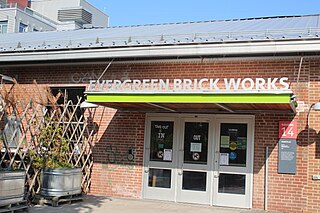
The Don Valley Brick Works is a former quarry and industrial site located in the Don River Valley in Toronto, Ontario, Canada. The Don Valley Brick Works operated for nearly 100 years and provided bricks used to construct many well-known Toronto landmarks, such as Casa Loma, Osgoode Hall, Massey Hall, and the Ontario Legislature. Since the closure of the original factory, the quarry has been converted into a city park which includes a series of naturalized ponds, while the buildings have been restored and opened as an environmentally focused community and cultural centre by Evergreen, a national charity dedicated to restoring nature in urban environments.

The Toronto waterfront is the lakeshore of Lake Ontario in the city of Toronto, Ontario, Canada. It spans 46 kilometres between the mouth of Etobicoke Creek in the west and the Rouge River in the east.

Toronto Harbour or Toronto Bay is a bay on the north shore of Lake Ontario, in Toronto, Ontario, Canada. It is a natural harbour, protected from Lake Ontario waves by the Toronto Islands. Today, the harbour is used primarily for recreational boating, including personal vessels and pleasure boats providing scenic or party cruises. Ferries travel from docks on the mainland to the Islands, and cargo ships deliver aggregates and raw sugar to industries located in the harbour. Historically, the harbour has been used for military vessels, passenger traffic and cargo traffic. Waterfront uses include residential, recreational, cultural, commercial and industrial sites.

The Leslie Street Spit, or officially the Outer Harbour East Headland, is a human-made headland in Toronto, Ontario, Canada, extending from the city's east end in a roughly southwesterly direction into Lake Ontario. It is about 5 kilometres (3 mi) long. The Spit is the result of five decades of lakefilling by the Toronto Port Authority. It was conceived as an extension of Toronto Harbour, and has evolved into a largely passive recreation area. Naturalization had not been planned but the process is now actively managed by the Toronto and Region Conservation Authority. A large portion of it is classified as an Environmentally Sensitive Area (ESA) and it is recognized as an Important Bird Area.
The Don Mills Centre was a shopping mall in Toronto, Ontario, Canada. It was located on a 44-acre commercial site, at the southwest corner of Don Mills Road and Lawrence Avenue East in Toronto. There were at least 98 stores during the height of the mall's existence. The majority of the mall was closed and demolished in summer 2006 for redevelopment as the Shops at Don Mills.
St. James-Bond United Church, at 1066 Avenue Road in Toronto, Ontario, was a United Church of Canada congregation from 1928 to 2005, when it merged with Fairlawn Heights United Church in the Yonge Street and Lawrence Avenue area. The "St. James-Bond" name derived from the merger of St. James Square Presbyterian Church with Bond Street Congregational Church in 1928. Prior to the merger, they were separate congregations downtown, of the Presbyterian and Congregational traditions respectively.

Canada Malting Silos is one of two remaining silos in Toronto's Harbourfront in Ontario, Canada. Located at the foot of Bathurst Street at Bathurst Quay, the silos were built in 1928 to store malt for the Canada Malting Company. It was an important work of industrial architecture, as grain elevators had long been built out of wood, and thus were at great danger of fire. The concrete malting towers were an innovation, and the stark functionalism of the prominent building was an early influence on modernist architecture. A round office was added in 1944 and glass office was built in the original construction in 1928. The main silos, 15 in all, are 120 feet high and additional storage bins built in 1944 are 150 feet high.
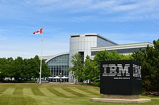
IBM Canada's head offices are currently located in Markham, Ontario and have been there since the early 1980s. The current building IBM occupies is located at 3600 Steeles Avenue East and was completed in 1995. IBM Canada's previous head office was located across the street at 3500 Steeles Avenue East.

The Golden Mile is a commercial district in the Scarborough district of Toronto, Ontario, Canada. Situated along Eglinton Avenue East, east of Victoria Park Avenue, it was one of Canada's first model industrial parks. The original Golden Mile of Industry ran along Eglinton from Pharmacy Avenue east to Birchmount Road.

Flemingdon Park is a neighbourhood in Toronto, Ontario, Canada, located in the city's North York district. It is part of the Don Valley East federal and provincial electoral districts, and Ward 26: Don Valley East (South) municipally. In 2011, its population was 22,205. The average income was $66,784.
The Galleria Shopping Centre is a shopping centre in Toronto, Ontario, Canada. It is located at the southwest corner of the intersection of Dufferin and Dupont Streets. The mall is in the process of being redeveloped into a mixed-use development. As it is in process of being demolished, only half of the building remains.

Canadian Breweries Limited (CBL), originally the Brewing Corporation of Ontario, was an Ontario-based holding company in the brewing industry. The company was founded in 1930 by a merger of two breweries, Brading of Ottawa and Kuntz of Kitchener-Waterloo. Under the direction of its top executive, E. P. Taylor, the company bought or merged many of the smaller competitors existing after the repeal of prohibition. The new company closed many plants, reduced the number of beer brands and built new, larger plants to produce enough beer for a much larger geographic area. By the 1950s, the company had reduced the number of beer brands from approximately one hundred to six. Canadian Breweries became part of a large conglomerate of manufacturing and consumer businesses controlled by the Argus Corporation in 1945.

Lambton House is a historic former inn in Toronto, Ontario, Canada. It is the last remaining building from the former village of Lambton Mills along the Humber River. The inn was established in 1847, with its present building erected in 1860.

The Ford Hotel was a historic hotel in central Toronto, Ontario, Canada. It was one of five hotels in the R.T. Ford & Company hotel chain and was identical to the Ford Hotel, Buffalo and Ford Hotel, Montreal. The 750-room hotel consisted of three 12-story wings connected at the rear by a perpendicular spine atop a one-story base contained the lobby, restaurants and other amenities. The structure was located on Dundas Street West, east of Bay Street. It was built in 1928 and for several decades was one of the city's most prominent hotels. The hotel was next to the Toronto Bus Terminal and provided cheap rooms for lower income travellers. It was also well known as a site for crime and vice. The Toronto Star called it the "rendezvous of choice for couples pursuing an illicit affair."
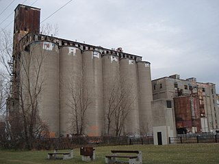
Maple Leaf Mills Silos was one of two silo or grain elevator complexes that were built in the area between Spadina Quay and Maple Leaf Quay, on Toronto Harbour, in Toronto, Ontario, Canada. It was one of three "monumental" silo complexes that dominated the city's waterfront.
Canadian Malting Silos is an abandoned malting factory located in the Saint-Henri neighbourhood of Montreal, Canada.

Quayside is a waterfront district slated for redevelopment in Toronto, Ontario, Canada. Formerly dockland and industrial uses, The Waterfront Toronto government agency intends for a new housing development to be built between the East Bayfront and Port Lands neighbourhoods, a site of 4.9 hectares of land. A smart city project was in the planning stages, proposed by Sidewalk Labs, a subsidiary of Alphabet Inc., named Sidewalk Toronto. Alphabet announced the cancellation of the project on May 7, 2020. Development of the site is now on hold.

Villiers Island is a 22-hectare (54-acre) area in Toronto's Port Lands being converted to an island. The project is a part of Port Lands Flood Protection Project by Waterfront Toronto. To prevent flooding from the Don River, a channel is being created to extend the river south and then west into Toronto Harbour providing another outlet and a more natural mouth for the Don River. The new channel effectively creates the island, which is also bounded by the Keating Channel and Toronto Harbour. Mixed-use residential development is planned for Villiers Island.
