Villa Sanagasta | |
|---|---|
Municipality and village | |
| Country | |
| Province | La Rioja Province |
| Time zone | UTC−3 (ART) |
Villa Sanagasta is a municipality and village in La Rioja Province in northwestern Argentina. [1]
Villa Sanagasta | |
|---|---|
Municipality and village | |
| Country | |
| Province | La Rioja Province |
| Time zone | UTC−3 (ART) |
Villa Sanagasta is a municipality and village in La Rioja Province in northwestern Argentina. [1]

The Arctic Archipelago, also known as the Canadian Arctic Archipelago, is an archipelago lying to the north of the Canadian continental mainland, excluding Greenland and Iceland.
Lophotrochozoa is a clade of protostome animals within the Spiralia. The taxon was established as a monophyletic group based on molecular evidence. The clade includes animals like annelids, molluscs, bryozoans, and brachiopods.

Joinville Island is the largest island of the Joinville Island group, about 40 nautical miles long in an east–west direction and 12 nautical miles wide, lying off the northeastern tip of the Antarctic Peninsula, from which it is separated by the Antarctic Sound.

The Heligoland Bight, also known as Helgoland Bight, is a bay which forms the southern part of the German Bight, itself a bay of the North Sea, located at the mouth of the Elbe river. The Heligoland Bight extends from the mouth of the Elbe to the islands of Heligoland and lies between the East Frisian island of Wangerooge and the North Frisian peninsula of Eiderstedt.
The Aviator Glacier is a major valley glacier in Antarctica that is over 60 nautical miles long and 5 nautical miles wide, descending generally southward from the plateau of Victoria Land along the west side of Mountaineer Range, and entering Lady Newnes Bay between Cape Sibbald and Hayes Head where it forms a floating tongue.
Fort Rixon is a village and farming centre in Matabeleland region of southwestern Zimbabwe. It is located some 48 miles (77 km) north-east of Bulawayo. It was founded as a military outpost in 1896 during the rebellion of the Matabele against British colonial rule of Rhodesia. Nowadays it has a Zulu lithium mine.

The Prince Charles Mountains are a major group of mountains in Mac. Robertson Land in Antarctica, including the Athos Range, the Porthos Range, and the Aramis Range. The highest peak is Mount Menzies, with a height of 3,228 m (10,591 ft). Other prominent peaks are Mount Izabelle and Mount Stinear. These mountains, together with other scattered peaks, form an arc about 420 km (260 mi) long, extending from the vicinity of Mount Starlight in the north to Goodspeed Nunataks in the south.
Quartermain Glacier is a well-defined, highly crevassed glacier on the north side of Fricker Glacier, from which it is separated in its upper reaches by Mount Kennett. It flows from the plateau into Mill Inlet on the east coast of Graham Land, and was named by the United Kingdom Antarctic Place-Names Committee (UK-APC) for Leslie B. Quartermain, New Zealand historian of the Antarctic and author of South to the Pole. The early history of the Ross Sea Sector.
Quest Channel is a channel leading southwestward from Adelaide Anchorage between Hibbert Rock and Henkes Islands, off the south end of Adelaide Island. It was named by the United Kingdom Antarctic Place-Names Committee (UK-APC) after the survey motorboat which charted this area in 1963.
The Hays Mountains are a large group of mountains and peaks of the Queen Maud Mountains of Antarctica, surmounting the divide between the lower portions of Amundsen Glacier and Scott Glacier and extending from the vicinity of Mount Thorne on the northwest to Mount Dietz on the southeast.
Cotiporã is a municipality in the state of Rio Grande do Sul, Brazil. As of 2020, the estimated population was 3,838.
Andalamasina Vineta is a town and commune in Madagascar. It belongs to the district of Sakaraha, which is a part of Atsimo-Andrefana Region. The population of the commune was estimated to be approximately 4,000 in 2001 commune census.
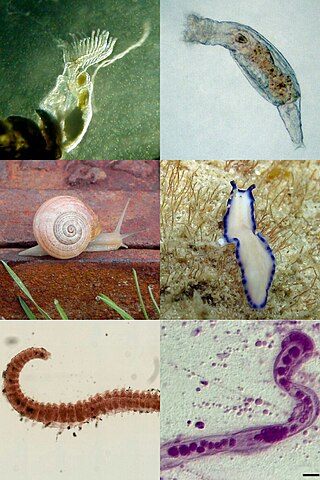
The Spiralia are a morphologically diverse clade of protostome animals, including within their number the molluscs, annelids, platyhelminths and other taxa. The term Spiralia is applied to those phyla that exhibit canonical spiral cleavage, a pattern of early development found in most members of the Lophotrochozoa.

Merthyr Cynog is a hamlet and a community in the modern county of Powys, Wales, in the historic county of Brecknockshire. The population of the community at the 2021 Census was 245.
Puerta de San José is a village and municipality in Catamarca Province in northwestern Argentina.

Bussey Glacier is a glacier flowing west from Mount Peary to the head of Waddington Bay on Kyiv Peninsula on the west coast of Graham Land. It was first charted by the French Antarctic Expedition under Jean-Baptiste Charcot, 1908–10, and named by the UK Antarctic Place-Names Committee in 1959 for Group Captain John Bussey of the Directorate of Overseas Surveys.

Caution Point is a headland 4 nautical miles (7 km) northeast of Mount Birks, on the north side of the entrance to Spillane Fjord, which marks the east end of Austa Ridge that forms the north wall of Crane Glacier, on the east coast of Graham Land. It was photographed from the air by Sir Hubert Wilkins on a flight of December 20, 1928, and named by the Falkland Islands Dependencies Survey who charted it in 1947.
The Phillips Mountains are a range of mountains on the north side of Balchen Glacier and Block Bay in the Ford Ranges, Marie Byrd Land, Antarctica.
Dandenong and Berwick was an electoral district of the Legislative Assembly in the Australian state of Victoria from 1889 to 1904. It was located south-east of Melbourne, in the area around Dandenong and Berwick.
| International | |
|---|---|
| National | |
29°16′S67°01′W / 29.267°S 67.017°W
| | This article about a place in La Rioja Province, Argentina is a stub. You can help Wikipedia by expanding it. |