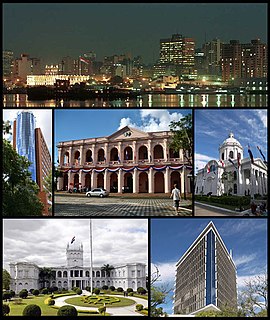
Asunción is the capital and largest city of Paraguay. The city is located on the left bank of the Paraguay River, almost at the confluence of this river with the River Pilcomayo, on the South American continent. The Paraguay River and the Bay of Asunción in the northwest separate the city from the Occidental Region of Paraguay and Argentina in the south part of the city. The rest of the city is surrounded by the Central Department.

Hudson Strait links the Atlantic Ocean and Labrador Sea to Hudson Bay in Canada. This strait lies between Baffin Island and Nunavik, with its eastern entrance marked by Cape Chidley in Newfoundland and Labrador and Resolution Island off Baffin Island. The strait is about 750 km long with an average width of 125 km, varying from 70 km at the eastern entrance to 240 km at Deception Bay.

Paraguay's bicameral Congress(Congreso) consists of a 45-member Senate and an 80-member Chamber of Deputies. It serves as the legislative branch of the Paraguayan state.
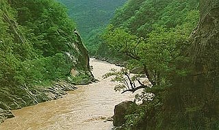
Pilcomayo is a river in central South America. At 1,100 kilometres (680 mi) long, it is the longest western tributary of the Paraguay River. Its drainage basin is 270,000 square kilometres (100,000 sq mi) in area, and its mean discharge is 200 cubic metres per second (7,100 cu ft/s).

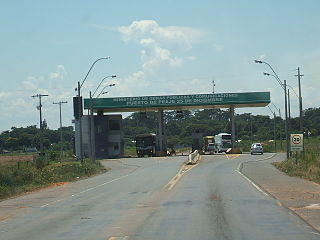
Coronel Oviedo, locally simply known as Oviedo, is a city in east-central Paraguay. It is the capital of the Caaguazú Department, about 150 kilometers east of Asunción, and was founded in 1758.
Doctor Juan León Mallorquin is a town and district of the Alto Paraná Department, Paraguay.

Antequera is a district of the San Pedro Department, Paraguay with Puerto Antequera the main location at the Paraguay River. It is an agricultural region. Puerto Antequera has 1,632 inhabitants.
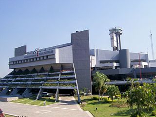
Luque is a city in Central Department of Paraguay, part of the Gran Asunción metropolitan area. Both 1635 and 1750 have been recorded as dates of its founding. It was temporarily the capital of Paraguay in 1868 during the Paraguayan War before relocation to San Estanislao. It is located at around 25°16′12″S57°29′14″W. Luque is one of the most important cities in the country. The city counts as home of Paraguay's main international airport, Silvio Pettirossi International Airport and the Ñu Guasú Park, which is where the Paraguayan Olympic Committee is also located. The continental governing body of association football in South America, CONMEBOL, has its headquarters approximately 3 minutes from the Airport, consisting of the South American Football Museum and walking distance from the Bourbon CONMEBOL Asunción Convention Hotel. When it existed, ARPA – Aerolíneas Paraguayas had its headquarters in the ARPA Terminal on the grounds of the airport. It is a center of production of Guitars and Paraguayan harps as well as Filigranas, gold and silver filigree jewelry including the seven-band ring Carretón de Siete Ramales. On 27 January 2016, Paraguayan Newspaper La Nación had reported that Carlos Echeverría Estigarribia, the elected intendent of the city of Luque, states his intention of wanting Luque to be one of the most important cities.
Val de San Lorenzo is a municipality located in the province of León, Castile and León, Spain. According to the 2004 census (INE), the municipality has a population of 674 inhabitants and a density of 12,89 inhabitants/km2.
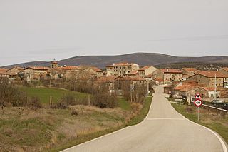
Campolara is a municipality located in the province of Burgos, Castile and León, Spain. According to the 2004 census (INE), the municipality has a population of 95 inhabitants.

Zucaina is a municipality in the comarca of Alto Mijares, Castellón, Valencia, Spain.

Savanes District is one of fourteen administrative districts of Ivory Coast. The district is located in the northernmost part of the country. The capital of the district is Korhogo.
Bahía Negra is a district in the department of Alto Paraguay, Paraguay.
Loreto is a district in the department of Concepción, Paraguay.
Paso Barreto is a district in the department of Concepción, Paraguay.
San Alfredo is a district in the department of Concepción, Paraguay.
Itá Pytã Punta is a neighbourhood (barrio) of Asunción, the capital and largest city of Paraguay.
Mburucuyá is a neighbourhood (barrio) of Asunción, the capital and largest city of Paraguay.
Virgen de Fátima is a neighbourhood (barrio) of Asunción, the capital and largest city of Paraguay.