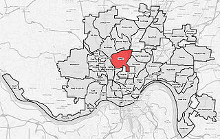
Springfield Township is one of the twelve townships of Hamilton County, Ohio, United States. The 2010 census found 36,319 people in the township. Springfield Township is home to the largest private school in Ohio, the largest lake in Hamilton County, and the Cincinnati area's annual Greek Festival.

U.S. Route 20 or U.S. Highway 20 (US 20) is an east–west United States Numbered Highway that stretches from the Pacific Northwest east to New England. The "0" in its route number indicates that US 20 is a major coast-to-coast route. Spanning 3,365 miles (5,415 km), it is the longest road in the United States, and, in the east, the route is roughly parallel to that of the newer Interstate 90 (I-90), which is the longest Interstate Highway in the U.S. There is a discontinuity in the official designation of US 20 through Yellowstone National Park, with unnumbered roads used to traverse the park.

Princeton High School is a public, co-educational high school in Sharonville, Ohio, United States. The school is a part of the Princeton City School District.

Princeton City School District is a city school district in northern Hamilton County, Ohio in the Cincinnati metropolitan area. The school district serves Glendale, Lincoln Heights, and Woodlawn; most of the cities of Sharonville, and Springdale; and parts of Blue Ash, Evendale, and Springfield Township. In addition the southeast part of Butler County's West Chester Township, the southwest corner of Warren County's Deerfield Township and the northwest corner of Sycamore Township are in the district.
Clifton is a neighborhood in the north central part of Cincinnati, Ohio, United States. The population was 8,304 at the 2010 census.

State Route 126 is a state route starting at the Ohio-Indiana border, at a split with State Route 129 near Scipio, Ohio, and ending east of Cincinnati at an intersection with U.S. Route 50 in Milford. State Route 126 is locally known for comprising most of Ronald Reagan Cross County Highway.

Cincinnati, Ohio is home to numerous structures that are noteworthy due to their architectural characteristics or historic associations. The city also boasts Fountain Square and a riverfront that is being revitalized under The Banks project.
The roads of Cincinnati, Ohio include three major interstate highways, one interstate bypass and one interstate spur and six U.S. highways.

U.S. Route 221 (US 221) is a part of the U.S. Highway System that runs from Perry, Florida to Lynchburg, Virginia. In Virginia, the U.S. Highway runs 149.61 miles (240.77 km) from the North Carolina state line near Independence north to its northern terminus at US 29 Business, US 460 Business, and US 501 Business in Lynchburg. US 221 connects Independence, Galax, and Hillsville in Southwest Virginia while running concurrently with US 58. The U.S. Highway connects those communities with Roanoke via Floyd County, within which US 221 is the main east–west highway. The U.S. Highway also runs concurrently with US 460 from Roanoke to Bedford and parallels that U.S. Highway from Bedford to Lynchburg.

Avondale is a neighborhood in Cincinnati, Ohio. It is home to the Cincinnati Zoo and Botanical Garden. The population was 12,466 at the 2010 census.

The Glendale Historic District encompasses the historic core of Glendale, Ohio. Developed in 1851, Glendale is one of the earliest known examples of a planned residential village subdivision, its layout made using principles developed for rural cemeteries popular at the time. The district features shaded winding residential lanes, and a large assemblage of well-preserved period buildings. The district was designated a National Historic Landmark in 1977.

CUF is a neighborhood in Cincinnati, Ohio. Its name is derived from the communities of Clifton Heights, University Heights, and Fairview. CUF is bordered by the neighborhoods of Clifton, the Heights, Mount Auburn, Over-the-Rhine, and Camp Washington.

Corryville is a neighborhood in Cincinnati, Ohio, east of the University of Cincinnati, southeast of Clifton, south and west of Avondale, northwest of Walnut Hills, and north of Mount Auburn. The population was 3,327 at the 2010 census.

The Cincinnati Bell Connector, previously known as the Cincinnati Streetcar, is a streetcar system in Cincinnati, Ohio, United States. The system opened to passengers on September 9, 2016. The streetcar operates on a 3.6-mile (5.8 km) loop from The Banks, Great American Ball Park, and Smale Riverfront Park through Downtown Cincinnati and north to Findlay Market in the northern edge of the Over-the-Rhine neighborhood. Future extensions have been proposed to the Uptown area, home to the University of Cincinnati, the regional hospitals on Pill Hill, and the Cincinnati Zoo; and to Northern Kentucky.
Downtown Cincinnati is the central business district of Cincinnati, Ohio, as well the economic and symbiotic center of the Cincinnati metropolitan area. It also contains a number of urban neighborhoods in the low land area between the Ohio River and the high land areas of uptown. These neighborhoods include Over-the-Rhine, Pendleton, Queensgate, and West End.

Frederick W. Garber was an American architect in Cincinnati, Ohio and the principal architect in the Garber & Woodward firm with Clifford B. Woodward (1880–1932). The firm operated from 1904 until it was dissolved in 1933 Their work has been described as in the Beaux-Arts tradition and included buildings on the University of Cincinnati campuses, schools, hospitals, commercial buildings, "fine residences" and public housing.
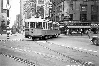
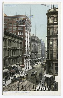
Streetcars operated by the Cincinnati Street Railway were the main form of public transportation in Cincinnati, Ohio, at the end of the 19th century and the start of the 20th century. The first electric streetcars began operation in 1889, and at its maximum, the streetcar system had 222 miles (357 km) of track and carried more than 100 million passengers per year. A very unusual feature of the system was that cars on some of its routes traveled via inclined railways to serve areas on hills near downtown. With the advent of inexpensive automobiles and improved roads, transit ridership declined in the 20th century and the streetcar system closed in 1951.
Pill Hill is an informal name for a neighborhood in uptown Cincinnati, Ohio. It is one of the city's major employment centers, with a large concentration of hospitals and other medical facilities.