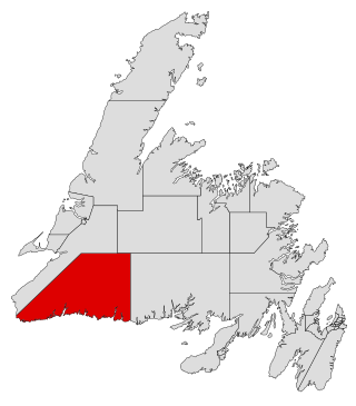
Burgeo-La Poile is a provincial electoral district for the House of Assembly of Newfoundland and Labrador, Canada. As of 2011, there are 7,527 eligible voters living within the district. The district was first created when Newfoundland joined confederation in 1949 as Burgeo and La Poile, and existed until 1975. It was recreated in 1995 following a reduction in the number of seats in the House of Assembly from 52 to 48, forming from the amalgamation of the former districts of La Poile and Burgeo-Bay D'Espoir.

Ferryland is a provincial electoral district for the House of Assembly of Newfoundland and Labrador, Canada. As of 2011, there are 8,571 eligible voters living within the district.

Quidi Vidi is a neighbourhood in St. John's, Newfoundland and Labrador. The village is adjacent to Quidi Vidi Lake. Quidi Vidi's harbour is known as "The Gut". Located in Quidi Vidi is the Quidi Vidi Battery Provincial Historic Site. The village is home to several small businesses.
Goulds is a designated place in the Canadian province of Newfoundland and Labrador. It is a rural neighbourhood within the City of St. John's southeast of the city centre.
Wedgewood Park is a neighbourhood in St. John's, Newfoundland and Labrador, located north of the city centre.
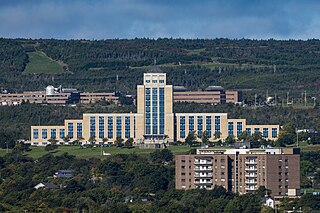
The Confederation Building serves as the home of the Newfoundland and Labrador House of Assembly. It is located on Confederation Hill overlooking Newfoundland and Labrador's capital city, St. John's. The brick- and concrete-clad building has 11 stories and is 64 metres (210 ft) tall. It was completed in 1960 at a cost of $9 million to replace the Colonial Building. A lantern is located at the top of the copper roof of the central tower and acts as a beacon when turned on at night.
Calvert is a local service district and designated place in the Canadian province of Newfoundland and Labrador in the Southern Shore region of the province. It is 72 kilometres south of the provincial capital St. John's, 7 kilometres south of Cape Broyle, and 3 kilometres north of Ferryland. The population in 2001 was 355, a decline of 17% since 1996.
Tors Cove is a local service district and designated place in the Canadian province of Newfoundland and Labrador. It is on the east coast of the Avalon Peninsula of the island of Newfoundland, approximately 40 kilometres south of the St. John's, the provincial capital, along Route 10. It was formerly named Toads Cove.

Pippy Park is a 3,400-acre (14 km2) urban park located in the city of St. John's, Newfoundland. The park is a popular camping, hiking and recreational park within the city, and incorporates numerous groomed and wilderness-style hiking/skiing trails, a miniature golf course, a 9-hole and an 18-hole golf course, a driving range, and a public access trailer park with limited tent camping facilities. Trails within the park link to the Grand Concourse walking trails.
La Manche was a community on the east coast of the Avalon Peninsula of the island of Newfoundland between Cape Broyle and Tors Cove in a small inlet surrounded by steep hills. In French, la manche means "the sleeve". The area is named for the shape of the harbour, which is long and narrow with high sides. This harbour was probably first used by the French because of its seclusion which offered cover between raids on Ferryland and St. John's.

Fort Amherst is a neighbourhood in St. John's, Newfoundland and Labrador. It is located at 47°33′48.96″N52°40′49.60″W, on the southern side of the Narrows, the entrance to St. John's harbour. Apart from some family dwellings, Fort Amherst consists of a man-made harbour, a lighthouse and the remains of gun emplacements built during World War II to defend against German U-boats. Two QF 4.7-inch B Mark IV* guns remain in place on their mountings.

Georgestown is a Neighbourhood Improvement Area in St. John's, Newfoundland and Labrador a short distance north from downtown of St. John's. This was established in the 1970s as part of an effort by Federal and local government to improve inner cities. Originally what was known as Georgestown village was much smaller and only "extended from Donnelly's Lane to what is now Belvedere Street". The neighbourhood improvement area includes, in addition to the original Georgestown, the former Monkstown and Tubridtown, along with adjoining land, including Circular Road, and Belvedere Street as well as some other parts of the former Belvedere Estate. It is bordered by Military Road, Monkstown Road, Empire Avenue, a small part of Carpasian Road, the east side of Bonaventure Avenue, and Holy Heart and Brother Rice Schools to the west. It was settled, around 1819, as the city's first suburb. The name is an evolution of "George (Winter)'s Town", as it was known in the 19th century.
The neighbourhood of Pleasantville in St. John's, Newfoundland and Labrador is located in the east end of the city, directly north of the downtown. The neighbourhood extends from the north side of Quidi Vidi Lake northward to Newfoundland Drive, and is largely made up of apartment blocks.
Kenmount Road is a major road in St. John's, Newfoundland and Labrador. It begins at the intersection of Freshwater Road and Thorburn Road, just east of the Columbus Drive overpass. Originally passing through rural farmland, Kenmount Road is now a significant commercial area, with the Avalon Mall at its eastern end, followed by a series of car dealerships, restaurants, hotels, and other businesses. At its western end, Kenmount Road intersects Topsail Road and the Trans-Canada Highway, and has been extended into the Town of Paradise, where it runs into another road, McNamara Drive.
Kilbride is a neighbourhood in St. John's, Newfoundland and Labrador.
The neighbourhood of Churchill Park in St. John's, Newfoundland and Labrador is located in the city's centre. The neighbourhood is bordered by Freshwater Road to the west, Empire Avenue to the south, Kenna's Hill, Kingsbridge and Torbay Roads to the east and Elizabeth Avenue to the north. Its main east-west thoroughfares are Elizabeth Avenue and Empire Avenue, and its main north-south thoroughfares are Portugal Cove Road and Allandale Road. The neighbourhood borders the campus of Memorial University of Newfoundland to the north, and as a result, it is home to a sizable student population. The area is made up of single-family homes, mostly built in the 1950s and 1960s.
Fort Waldegrave was a battery or an emplacement for heavy guns in St. John’s Newfoundland, strategically overlooking the Narrows and St John’s Harbour.
Division No. 1, Subdivision U is an unorganized subdivision on the Avalon Peninsula in Newfoundland and Labrador, Canada, in Division 1. It contains the unincorporated communities of Admiral's Cove, Bauline East, Bauline South, Burnt Cove, Devils Kitchen, Flat Rock, St. Michaels and Seal Cove.
