
The Madras Presidency or Madras Province, officially called the Presidency of Fort St. George until 1937, was an administrative subdivision (province) of British India and later the Dominion of India. At its greatest extent, the presidency included most of southern India, including all of present-day Andhra Pradesh, almost all of Tamil Nadu and parts of Kerala, Karnataka, Odisha and Telangana in the modern day. The city of Madras was the winter capital of the presidency and Ooty was the summer capital.

Vizianagaram district is one of the six districts in the Uttarandhra region of the Indian state of Andhra Pradesh with its headquarters located at Vizianagaram. The district was once the part of ancient Kalinga.Saripilli Dibbilingeswara temple, Jayathi Mallikarjuna Temple are the finest examples of ancient Eastern Ganga Dynasty built monuments in the district. The district is bounded on the east by the district of Srikakulam, north by Parvathipuram Manyam south by Visakhapatnam, Anakapalli, southeast by the Bay of Bengal, and west by Alluri Sitharama Raju district. It was formed on 1 June 1979, with some parts carved from the neighbouring districts of Srikakulam and Visakhapatnam. The district is named after the princely state of Vizianagaram. In 2011, it was the least populous district in Andhra Pradesh.

Srikakulam district is one of the twenty-six districts of the Indian state of Andhra Pradesh, located in the Uttarandhra region of the state, with its headquarters located at Srikakulam. It is one of the six districts, located in the extreme northeastern direction of the state. It was formerly known as Chicacole, and was under Ganjam district till 1936 April 1, then merged under Vizagapatam district. Srikakulam district forms the core area of Kalinga where most of its historical capitals like Kalinganagari, pithunda, Dantapuram are located.

Visakhapatnam district is one of the six districts in the Uttarandhra region of the Indian state of Andhra Pradesh, headquartered at Visakhapatnam. It is one of the twenty-six districts in Andhra Pradesh state. The district shares borders within the north and east, Vizianagaram district and South Anakapalli district in the south-west and Bay of Bengal in the south.

Bobbili is a town in Vizianagaram district of the Indian state of Andhra Pradesh.
Raja Sri Ravu SvetachalapatiSir Ramakrishna Ranga RaoKCIE was an Indian politician and zamindar who served as the First Minister of Madras Presidency from 5 November 1932 to 4 April 1936 and 24 August 1936 to 1 April 1937.
Salur or Saluru is a municipal town and mandal headquarters in Parvathipuram Manyam district, of the Indian state of Andhra Pradesh.

An agency of British India was an internally autonomous or semi-autonomous unit of British India whose external affairs were governed by an agent designated by the Viceroy of India.
Rampa rebellion of 1879 was an insurrection by the hill tribes in the Rampa region of the Vizagapatam Hill Tracts Agency of Vizagapatam District against the British government of the Madras Presidency.
The name is derived from its founder Raja Vijayaram Raj who established a sovereign kingdom by claiming independence from the Kingdom of Jeypore in 1711. It formed alliances with the French and British East India Company to conquer the neighbouring principalities of Bobbili, Kurupam, Paralakhemundi and the Kingdom of Jeypore. However, they fell out with the British and as a result were attacked and defeated in the Battle of Padmanabham. They were annexed as a tributary estate like other principalities and remained so until their accession to the Indian Union in 1949.
Ganjam Hill Tracts Agency was an agency in the Ganjam district of the erstwhile Madras Presidency, British India. It was created by the Act XXIV of 1839 from the 'Maliahs' or Highlands, the tribal lands inhabited by the Khonds and the Soras. The territory consists of the western part of Ganjam district. It was about five-twelfths of the district and had a total area of 3,500 square miles.
Vizagapatam District was a district in the Madras Presidency of British India. Covering an area of 44,600 square kilometres (17,222 sq mi) and sub-divided into 22 taluks.
Orissa Province was a province of British India created in April 1936 by the partitioning of the Bihar and Orissa Province and adding parts of Madras Presidency and Central Provinces. Its territory corresponds with the modern-day State of Odisha.
Salur mandal is one of the 34 mandals in Parvathipuram Manyam district of the Indian state of Andhra Pradesh. It is administration under Parvathipuram revenue division and headquartered at Salur. The mandal is bounded by Makkuva, Ramabhadrapuram, Pachipenta and Bobbili mandals. A portion of it also borders the state of Odisha.
Makkuva mandal is one of the 34 mandals in Parvathipuram Manyam district of the Indian state of Andhra Pradesh. It is administration under Parvathipuram revenue division and headquartered at Makkuva. The mandal is bounded by Salur mandal on South & West, Parvathipuram mandal on North, Seethanagaram mandal on east and Bobbili mandal on south east. A portion of it also borders the Narayanapatna block of the Koraput district of Odisha on north west.
Pachipenta mandal is one of the 34 mandals in Parvathipuram Manyam district of the Indian state of Andhra Pradesh. It is administration under Parvathipuram revenue division and headquartered at Pachipenta. The mandal is bounded by Salur, Ramabhadrapuram and Mentada mandals. A portion of it also borders the state of Odisha.
Badangi mandal is one of the 34 mandals in Vizianagaram district of Andhra Pradesh, India. Badangi is the headquarters of the mandal. In Early 18th century Pinpenki, Badangi, Anavaram and kusumur ruled by Shri Ravu Venkata Rayanym Dora Garu now their family also residing in Pinapenki near Gadhaba valasa their family members Started "RVR Foundation" on the name of Shri Ravu Vittal Rao Dora Garu to help poor children. Founder & President "Shri Ravu Venkata Aditya Mohan", He is conducting child development activities and giving financial / moral support. The mandal is bounded by Bobbili, Therlam, Merakamudidam and Ramabhadrapuram mandals.
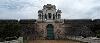
The Bobbili Fort, located in the Vizianagaram district of the Indian state of Andhra Pradesh, was built during the middle of the 19th century in Bobbili. It has a historical link to the nearby mud fort of the same name which was destroyed during the Bobbili war in 1757 in a feud between the Rajas of Bobbili and the neighbouring Maharaja of Vizianagaram.
Bobbili Estate was a Zamindari in the Vizagapatam District of the Madras Presidency, presently in the Vizianagaram district, Andhra Pradesh, India. It comprises 153 Jeroyati villages, 53 Agraharams, 5 Mokhasas by 1907 and a revenue of 8,33,000/- by 1938. It is one of the most influential Zamindari. It is spread over 300 square miles. It also bought shares in many estates like Kirlampudi, Dontamuru etc. It prospered in the period of British Raj.
The village of Kotia is the headquarters of a Gram Panchayat of the same name in the Pottangi block of Koraput District in Odisha, India. Along with other villages of the Gram Panchayat, it is the subject of a long pending border dispute between the states of Odisha and Andhra Pradesh, which claims it as a part of Salur mandal in Parvathipuram Manyam district of the State.