Look up volcanic in Wiktionary, the free dictionary.
Volcanic is an adjective used for things and concepts related to volcanos.
Contents
It may also refer to:
Volcanic is an adjective used for things and concepts related to volcanos.
It may also refer to:

A National Scenic Byway is a road recognized by the United States Department of Transportation for one or more of six "intrinsic qualities": archeological, cultural, historic, natural, recreational, and scenic. The program was established by Congress in 1991 to preserve and protect the nation's scenic but often less-traveled roads and promote tourism and economic development. The National Scenic Byways Program (NSBP) is administered by the Federal Highway Administration (FHWA).

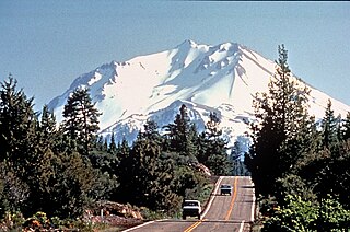
The Shasta–Trinity National Forest is a federally designated forest in northern California, United States. It is the largest National Forest in California and is managed by the U.S. Forest Service. The 2,210,485 acre forest encompasses five wilderness areas, hundreds of mountain lakes and 6,278 miles (10,103 km) of streams and rivers. Major features include Shasta Lake, the largest man-made lake in California and Mount Shasta, elevation 14,179 feet (4,322 m).

State Route 89 is a state highway in the U.S. state of California that travels in the north–south direction, serving as a major thoroughfare for many mountain communities in the Sierra Nevada and the Cascade Range. It starts from U.S. Route 395 near Topaz Lake, winding its way up to the 8,314-foot (2,534 m) Monitor Pass, down to the Carson River, and up again over the 7,740-foot (2,359 m) Luther Pass. From that point on, the route generally loses elevation on its way past Lake Tahoe, through Tahoe and Plumas National Forests until Lake Almanor. For roughly nine miles the route is then a part of State Route 36. The route then ascends to the 5,753-foot (1,754 m) Morgan Summit. After it enters Lassen Volcanic National Park it continues to gain elevation until it reaches its highest point in an unnamed pass in the middle of Lassen Peak and Bumpass Mountain. The road then descends and heads northwest, finally terminating at Interstate 5 at the foot of Mount Shasta at around 3,600 feet (1,100 m).

State Route 36 is an east–west state highway in the U.S. state of California that is routed from U.S. Route 101 in Humboldt County to U.S. Route 395 just east of Susanville in Lassen County. The highway passes through Red Bluff, the county seat of Tehama County, on the northern edge of the Sacramento Valley. The portion of SR 36 travelling past Lassen Volcanic National Park and Lake Almanor is part of the Volcanic Legacy Scenic Byway, a National Scenic Byway. Also, Route 36 between Alton and Susanville is a designated Blue Star Memorial Highway.
The Volcanic Legacy Scenic Byway is a scenic byway and All-American Road in the U.S. states of California and Oregon. It is roughly 500 miles (800 km) long and travels north–south along the Cascade Range past numerous volcanoes. It is composed of two separate National Scenic Byways, the Volcanic Legacy Scenic Byway - Oregon and Volcanic Legacy Scenic Byway - California. The former includes Rim Drive within Crater Lake National Park, while the latter wholly includes the Lassen Scenic Byway within Lassen Volcanic National Park.

State Route 44 is a state highway in the U.S. State of California that travels in an east–west direction from State Routes 273 and 299 in Redding to Lassen Volcanic National Park before ending at State Route 36 west of Susanville. This final portion, between the park and its terminus, is part of the Volcanic Legacy Scenic Byway, a National Scenic Byway.
Lewis and Clark Highway may refer to:
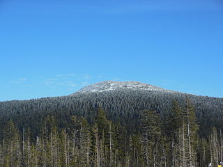
Tumalo Mountain is a shield volcano in the Cascade Range of central Oregon, located just northeast of Mount Bachelor across the Cascade Lakes Scenic Byway.
Santa Fe Trail is a historic 19th century transportation route.
Devil's Kitchen may refer to:
Spearfish Canyon is a deep but narrow gorge carved by Spearfish Creek located in Lawrence County, South Dakota, U.S., just south of Spearfish. The canyon is located within the Black Hills, located on the northern edge of the Black Hills National Forest. The Spearfish Canyon Scenic Byway travels through the Canyon from Spearfish to Cheyenne Crossing along U.S. Route 14A. The highway follows an old railroad grade that was abandoned after massive flooding in 1933.
Trout Creek Hill is a small Pleistocene basaltic shield volcano in Washington, United States. Located in Skamania County, Trout Creek Hill rises to an elevation of 2,946 feet (898 m). It is part of the Cascade Volcanic Arc, located in the Marble Mountain-Trout Creek Hill volcanic field.

The Peter Norbeck Scenic Byway is a National Scenic Byway in the Black Hills National Forest in the southwestern part of the U.S. state of South Dakota. It is a loop which is composed of portions of U.S. Route 16A (US 16A), South Dakota Highway 244 (SD 244), SD 87, and SD 89. Parts of the byway enter Black Hills National Forest, Custer State Park, and the Mount Rushmore National Memorial; the byway also travels within five miles of the Crazy Horse Memorial. The byway is named after Peter Norbeck, who served as governor of and senator for South Dakota.
Volcanic Hills may refer to:
Harriet Tubman Underground Railroad Scenic Byway may refer to:

The Black River National Forest Scenic Byway is a National Forest Scenic Byway that runs along the Black River in the Ottawa National Forest in the U.S. state of Michigan. The byway follows County Road 513 (CR 513) through Gogebic County in the Upper Peninsula. As a county road, it is maintained jointly by the Gogebic County Road Commission (GCRC) with assistance from the U.S. Forest Service (USFS). The byway provides access to several waterfalls and other visitor attractions in the area. The route of the byway first existed as a wagon road in the 1840s and as a county road in the 1920s. The byway designation was instituted on June 20, 1992, and the byway was dedicated later that year.

The Rio Grande del Norte National Monument is an approximately 242,555-acre (98,159 ha) area of public lands in Taos County, New Mexico, United States, proclaimed as a national monument on March 25, 2013, by President Barack Obama under the provisions of the Antiquities Act. It consists of the Rio Grande Gorge and surrounding lands, managed by the Bureau of Land Management (BLM).

The Trail of the Ancients is a New Mexico Scenic Byway to prehistoric archaeological and geological sites of northwestern New Mexico. It provides insight into the lives of the Ancestral Puebloans and the Navajo, Ute, and Apache peoples. Geological features include canyons, volcanic rock features, and sandstone buttes. Several of the sites are scenic and wilderness areas with recreational opportunities.