| Von River | |
|---|---|
 Braided section of the Von River, with cows having unimpeded access | |
| Location | |
| Country | New Zealand |
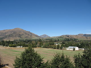
The Von River is a river in New Zealand, flowing into Lake Wakatipu. It was named after explorer Nicholas von Tunzelmann.
| Von River | |
|---|---|
| Braided section of the Von River, with cows having unimpeded access | |
| Location | |
| Country | New Zealand |
The Von River is a river in New Zealand, flowing into Lake Wakatipu. It was named after explorer Nicholas von Tunzelmann.

Mount Terror is a large shield volcano that forms the eastern part of Ross Island, Antarctica. It has numerous cinder cones and domes on the flanks of the shield and is mostly under snow and ice. It is the second largest of the four volcanoes which make up Ross Island and is somewhat overshadowed by its neighbor, Mount Erebus, 30 km (19 mi) to the west. Mt. Terror was named in 1841 by Sir James Clark Ross for his second ship, HMS Terror. The captain of Terror was Captain Francis Crozier who was a close friend of Ross and for whom the nearby Cape Crozier is named.
The Dobson River is a river in the South Island of New Zealand. It flows south between the Neumann and Ohau ranges for 45 kilometres (28 mi) from its source to the east of Mount Hopkins, in the Southern Alps, before joining with the Hopkins River, close to the latter's entry into the northern end of Lake Ohau in the Mackenzie Country. The river flows over wide shingle beds, and has no rapids of interest to whitewater enthusiasts. It was named by Julius von Haast in the 1860s for his father-in-law, Edward Dobson, who was the Canterbury Provincial Engineer.

Lumsden is a town in Southland, New Zealand. Lying in a gap in the surrounding hills, it is the location of a major junction halfway along the north–south road from Queenstown to Invercargill, where it is crossed by the east–west road from Gore to Te Anau. The town had a population of 405 at the 2013 census.

Kingston is a small town at the southernmost end of Lake Wakatipu, just north of the border of Otago and Southland, in New Zealand's South Island. It is 47 kilometres south of Queenstown by a road, "The Devil's Staircase", which winds between the lake to the west and The Remarkables mountains to the east. It is 70 kilometres north of Lumsden, and close to the headwaters of the Mataura River.

The Oreti River is one of the main rivers of Southland, New Zealand, and is 170 kilometres (110 mi) long. The river has been identified as an Important Bird Area by BirdLife International because, for much of its length, it supports breeding colonies of black-billed gulls.
The Dominion Range is a broad mountain range, about 48 km (30 mi) long, forming a prominent salient at the juncture of the Beardmore and Mill glaciers in Antarctica. The range is part of the Queen Maud Mountains

Borchgrevink Glacier is a large glacier in the Victory Mountains, Victoria Land, draining south between Malta Plateau and Daniell Peninsula, and thence projecting into Glacier Strait, Ross Sea, as a floating glacier tongue, the Borchgrevink Glacier Tongue, just south of Cape Jones. It was named by the New Zealand Geological Survey Antarctic Expedition, 1957–58, for Carsten Borchgrevink, leader of the British Antarctic Expedition, 1898–1900. Borchgrevink visited the area in February 1900 and first observed the seaward portion of the glacier.
Lake Gunn is a lake in the South Island of New Zealand, located at 44°53′S168°05′E.
Anama is a sparsely populated locality in the Canterbury region of New Zealand's South Island. It is on the Hinds River, with the Ashburton River not far to the north in nearby Mount Somers. Other nearby settlements include Valetta to the east, Mayfield to the south, and Montalto to the west. Anama School celebrated its centenary in March 2002.
Athol is a small town in Southland, New Zealand. It is located on State Highway 6, 55 km south of Queenstown, halfway between Lumsden and Kingston on the Southern Scenic Route. Farming has always been very important in the district, though in earlier times gold mining, centred on nearby Nokomai, was also significant. In recent decades tourist numbers have grown. The Mataura River is well known for the quality of its brown trout fishing, and the Around the Mountains Cycle Trail, opened in November 2014, has further boosted visitor figures.
Glenpark is a lightly populated rural locality in the Otago region of New Zealand's South Island. It is northwest of Palmerston and is on the banks of the Shag River. To the west is the locality of Stoneburn.
The Kauru River is a river of North Otago, New Zealand. A tributary of the Kakanui River, it rises in the east of the Kakanui Mountains and flows into that river west of Kia Ora.
Not to be confused with the River Lochy in Scotland.
The Nokomai River is a river in New Zealand, a tributary of the Mataura River.
The Waikaia River is a river in New Zealand, a tributary of the Mataura River.
The Windley River is a river in the Eyre Mountains, New Zealand. It is a tributary of the Oreti River, joining that river 6 kilometres (4 mi) north-east of Centre Hill.

The Freyberg Mountains are a group of mountains in Victoria Land, Antarctica, bounded by Rennick Glacier, Bowers Mountains, Black Glacier, and Evans Neve. Named for New Zealand's most famous General, Lord Bernard Freyberg, by the Northern Party of New Zealand Geological Survey Antarctic Expedition (NZGSAE), 1963-64. This mountain group includes the Alamein Range. These topographical features all lie situated on the Pennell Coast, a portion of Antarctica lying between Cape Williams and Cape Adare.
Frame Ridge is a small straight ridge in the central part of Brown Peninsula, Victoria Land, Antarctica. It is located just north of the small, central lake on the peninsula and extends northward down to Tuff Bluff. It was named by the New Zealand Antarctic Place-Names Committee for Alexander Oswald Frame, a paleontology technician with the New Zealand Geological Survey and Victoria University of Wellington who discovered the ridge on an expedition to the area, 1964–65.

Kaiwhaiki is a settlement 18 kilometres (11 mi) upriver from Whanganui, New Zealand.
"Place name detail: Von River". New Zealand Gazetteer. Land Information New Zealand . Retrieved 12 July 2009.
Coordinates: 45°05′S168°26′E / 45.083°S 168.433°E
| This article about a river in the Otago region is a stub. You can help Wikipedia by expanding it. |