
Rindal is a municipality in Trøndelag county, Norway. It is part of the Orkdalen region. The administrative centre is the village of Rindal. Other villages in the municipality include Tiset and Romundstad. The municipality centres on agriculture and forestry services.

Rauma is a municipality in Møre og Romsdal county, Norway. It is part of the traditional district of Romsdal. The administrative centre is the town of Åndalsnes. Other settlements in Rauma include the villages of Vågstranda, Måndalen, Innfjorden, Veblungsnes, Verma, Isfjorden, Eidsbygda, Rødven, Åfarnes, and Mittet. Most settlement in the municipality is located along the fjords and in the Romsdalen valley.

Gjemnes is a municipality in Møre og Romsdal county, Norway on the Romsdal peninsula. It is part of the Nordmøre region. The administrative centre is the village of Batnfjordsøra, which lies along the Batnfjorden and it is a former steamship landing place. Other villages in Gjemnes include Torvikbukt, Flemma, Angvika, Gjemnes, Øre, and Osmarka.

Angvik or Angvika is a small village in Gjemnes Municipality in Møre og Romsdal county, Norway. The village is located along the western shores of the Tingvollfjorden, just across the fjord from the village of Tingvollvågen.

Åndalsnes (help·info) is a town in Rauma Municipality in Møre og Romsdal county, Norway. Åndalsnes is the administrative center of Rauma Municipality. The 2.22-square-kilometre (550-acre) town has a population (2013) of 2,244, giving it a population density of 1,011 inhabitants per square kilometre (2,620/sq mi). The village of Isfjorden lies about 7 kilometres (4.3 mi) to the east, Veblungsnes lies just to the west across the Rauma River, and Innfjorden lies about 10 kilometres (6.2 mi) to the southwest via the European Route E136 highway.
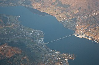
Ikornnes is a village in Sykkylven Municipality in Møre og Romsdal county, Norway. It is located along the Sykkylvsfjorden, about 4 kilometres (2.5 mi) east of Tusvik, 7 kilometres (4.3 mi) north of Straumgjerde, and about 3 kilometres (1.9 mi) west of the municipal center of Aure via the Sykkylven Bridge.

Sjøholt is the administrative centre of Ørskog Municipality in Møre og Romsdal county, Norway. The village is located along the northern shore of the Storfjorden, about 10 kilometres (6.2 mi) east of the village of Skodje. The village of Stordal is located about 18 kilometres (11 mi) to the south, through several tunnels. Sjøholt is located roughly halfway between the towns of Ålesund and Molde, along European route E39 and European route E136.

Raudsand or Rausand is a village in Nesset Municipality in Møre og Romsdal county, Norway. It is located on the Romsdal peninsula along the Tingvollfjorden about 9 kilometres (5.6 mi) northeast of the village of Eidsvåg and 8 kilometres (5.0 mi) south of the village of Angvika in Gjemnes Municipality. The 0.45-square-kilometre (110-acre) village has a population (2013) of 277, which gives the village a population density of 616 inhabitants per square kilometre (1,600/sq mi).

Sæbø is a village in Ørsta Municipality in Møre og Romsdal county, Norway. The village is located along the Hjørundfjorden in the Bondalen valley. It is about 5 kilometres (3.1 mi) north of the mountain Skårasalen. The village of Store-Standal lies about 6 kilometres (3.7 mi) to the north and the villages of Leira and Bjørke lie about 11 kilometres (6.8 mi) to the south.
Kornstad is a village in Møre og Romsdal county, Norway. The village is located in the present-day Averøy Municipality, on the west side of the island of Averøya, along the Kornstadfjorden. Kornstad Church is located in this village. The village of Visnes lies directly across the fjord from Kornstad village.
Innfjorden is a village in Rauma Municipality in Møre og Romsdal county, Norway. It is situated about 10 kilometres (6.2 mi) southwest of the town of Åndalsnes and 9 kilometres (5.6 mi) southeast of the village of Måndalen along the European Route E136 highway. The road from Åndalsnes to Innfjorden goes through the 6,594-metre (21,634 ft) long Innfjord Tunnel, which opened in 1991 after a series of deaths caused by avalanches on the former road along the shore of Romsdal Fjord.

Boggestranda is a village in Nesset Municipality in Møre og Romsdal county, Norway. It is located along the east shore of the Eresfjorden, about 10 kilometres (6.2 mi) south of the village of Eidsvåg and 10 kilometres (6.2 mi) north of the village of Eresfjord. There are some very old rock carvings in Boggestranda.
Myklebostad is a village in the Vistdal valley in Nesset Municipality in Møre og Romsdal county, Norway. The village is located along the south side of the Langfjorden, just west of the mouth of the Eresfjorden, about 10 kilometres (6.2 mi) southwest of the municipal center of Eidsvåg. The village of Eresfjord lies about 18 kilometres (11 mi) to the southeast through the Vistdal valley. The village was a part of the former municipality of Eresfjord og Vistdal from 1890 until 1964. Vistdal Church is located in Myklebostad.
Liabøen or Liabø is the administrative centre of Halsa Municipality in Møre og Romsdal county, Norway. The village is located along the Skålvik Fjord, along the European route E39 highway, about 10 kilometres (6.2 mi) northeast of the village of Halsanaustan and about 10 kilometres (6.2 mi) west of the village of Valsøyfjord. Liabøen has a bank, store, cafe, and school in addition to the administrative offices of the municipality.
Nedre Frei is a village in Kristiansund Municipality in Møre og Romsdal county, Norway. The village is located along the Freifjorden on the southern part of the island of Frei. The village sits about 8 kilometres (5.0 mi) south of the village of Rensvik and about 6 kilometres (3.7 mi) southwest of the village of Kvalvåg. Nedre Frei is the site of Frei Church, the main church for the island.

Øksendalsøra is a village in Sunndal Municipality in Møre og Romsdal county, Norway. The village is located along the Sunndalsfjorden at the northern end of the Øksendalen valley. The village sits about 10 kilometres (6.2 mi) northwest of the municipal centre of Sunndalsøra. The 6-kilometre (3.7 mi) long Øksendal Tunnel connects this village to the rest of Sunndal Municipality.
Røvika is a village in Molde Municipality in Møre og Romsdal county, Norway. The village is located at the end of the Karlsøyfjorden on the Romsdal Peninsula, about 10 kilometres (6.2 mi) southeast of the town of Molde. The village sits along the Norwegian County Road 64, at the eastern end of the Bolsøy Bridge. Røvik Church is located in the village.
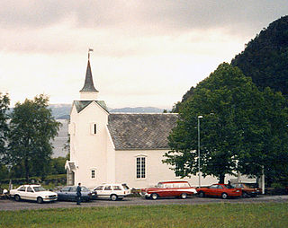
Vågstranda Church is a parish church in Rauma Municipality in Møre og Romsdal county, Norway. It is located in the village of Vågstranda on the coast of Romsdal Fjord. The church is part of the Vågstranda parish in the Indre Romsdal deanery in the Diocese of Møre. The white wooden church was built in 1870. The church seats about 200 people.
Måndalen is a village in Rauma Municipality in Møre og Romsdal county, Norway. The village is located along the Romsdalsfjorden about 20 kilometres (12 mi) west of the town of Åndalsnes. The European route E136 highway goes through Voll, connecting it to the village of Vågstranda [10 kilometres (6.2 mi) to the north] and the village of Innfjorden [10 kilometres (6.2 mi) to the southeast].
Måndalen is a village in Rauma Municipality in Møre og Romsdal county, Norway. The village is located along the Romsdalsfjorden about 20 kilometres (12 mi) west of the town of Åndalsnes. The European route E136 highway goes through Voll, connecting it to the village of Vågstranda [10 kilometres (6.2 mi) to the north] and the village of Innfjorden [10 kilometres (6.2 mi) to the southeast].


