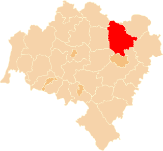
Trzebnica County is a unit of territorial administration and local government (powiat) in Lower Silesian Voivodeship, south-western Poland. It came into being on January 1, 1999, as a result of the Polish local government reforms passed in 1998. The county covers an area of 1,025.5 square kilometres (395.9 sq mi). Its administrative seat is Trzebnica, and it also contains the towns of Oborniki Śląskie, Żmigród and Prusice.

Adam Mickiewicz Monument in Kraków,, is one of the best known bronze monuments in Poland, and a favourite meeting place at the Main Market Square in the Old Town district of Kraków.

Kupa Synagogue is a 17th-century synagogue in Kraków, Poland. It is located in the former Jewish quarter of Kazimierz developed from a neighborhood earmarked in 1495 by King Jan I Olbracht for the Jewish community, which has been transferred from the budding Old Town. Kupa Synagogue serves Kraków's Jewish community as one of the venues for religious ceremonies and cultural festivals, notably the annual Jewish Culture Festival in Kraków.

Głęboka is a village in the administrative district of Gmina Ziębice, within Ząbkowice Śląskie County, Lower Silesian Voivodeship, in south-western Poland. Prior to 1945 it was in Germany.
Chłopiatyn is a village in the administrative district of Gmina Dołhobyczów, within Hrubieszów County, Lublin Voivodeship, in eastern Poland, close to the border with Ukraine. It lies approximately 15 kilometres (9 mi) south of Dołhobyczów, 40 km (25 mi) south of Hrubieszów, and 132 km (82 mi) south-east of the regional capital Lublin. The village is located in the historical region Galicia.
Korczyska is a village in the administrative district of Gmina Sędziejowice, within Łask County, Łódź Voivodeship, in central Poland. It lies approximately 7 kilometres (4 mi) south of Sędziejowice, 15 km (9 mi) south of Łask, and 46 km (29 mi) south-west of the regional capital Łódź.
Swolszewice Duże is a village in the administrative district of Gmina Wolbórz, within Piotrków County, Łódź Voivodeship, in central Poland.
Żarnowica Duża is a village in the administrative district of Gmina Wolbórz, within Piotrków County, Łódź Voivodeship, in central Poland. It lies approximately 5 kilometres (3 mi) south of Wolbórz, 14 km (9 mi) north-east of Piotrków Trybunalski, and 44 km (27 mi) south-east of the regional capital Łódź.
Świniary is a village in the administrative district of Gmina Drwinia, within Bochnia County, Lesser Poland Voivodeship, in southern Poland. It lies approximately 4 kilometres (2 mi) north of Drwinia, 17 km (11 mi) north of Bochnia, and 39 km (24 mi) east of the regional capital Kraków.
Zawada is a village in the administrative district of Gmina Dębica, within Dębica County, Subcarpathian Voivodeship, in south-eastern Poland. It lies approximately 6 kilometres (4 mi) east of Dębica and 38 km (24 mi) west of the regional capital Rzeszów.
Mielimąka is a settlement in the administrative district of Gmina Szamocin, within Chodzież County, Greater Poland Voivodeship, in west-central Poland. It lies approximately 5 kilometres (3 mi) west of Szamocin, 12 km (7 mi) east of Chodzież, and 70 km (43 mi) north of the regional capital Poznań.
Buszkowo-Parcele is a village in the administrative district of Gmina Skulsk, within Konin County, Greater Poland Voivodeship, in west-central Poland.
Paniewo is a village in the administrative district of Gmina Skulsk, within Konin County, Greater Poland Voivodeship, in west-central Poland. It lies approximately 3 kilometres (2 mi) south-west of Skulsk, 28 km (17 mi) north of Konin, and 96 km (60 mi) east of the regional capital Poznań.
Ryn is a village in the administrative district of Gmina Sompolno, within Konin County, Greater Poland Voivodeship, in west-central Poland.
Ostrówek is a village in the administrative district of Gmina Wierzbinek, within Konin County, Greater Poland Voivodeship, in west-central Poland.
Bogdałów is a village in the administrative district of Gmina Brudzew, within Turek County, Greater Poland Voivodeship, in west-central Poland. It lies approximately 3 kilometres (2 mi) south of Brudzew, 9 km (6 mi) north-east of Turek, and 121 km (75 mi) east of the regional capital Poznań.
Tuczenko is a settlement in the administrative district of Gmina Strzelce Krajeńskie, within Strzelce-Drezdenko County, Lubusz Voivodeship, in western Poland. It lies approximately 14 kilometres (9 mi) north of Strzelce Krajeńskie and 32 km (20 mi) north-east of Gorzów Wielkopolski.
Dzierżążnik is a settlement in the administrative district of Gmina Studzienice, within Bytów County, Pomeranian Voivodeship, in northern Poland. It lies approximately 7 kilometres (4 mi) south-west of Studzienice, 9 km (6 mi) south of Bytów, and 82 km (51 mi) south-west of the regional capital Gdańsk.
Wymysłowo is a settlement in the administrative district of Gmina Osiek, within Starogard County, Pomeranian Voivodeship, in northern Poland. It lies approximately 4 kilometres (2 mi) south-west of Osiek, 30 km (19 mi) south of Starogard Gdański, and 75 km (47 mi) south of the regional capital Gdańsk.
Ratajki is a village in the administrative district of Gmina Sianów, within Koszalin County, West Pomeranian Voivodeship, in north-western Poland. It lies approximately 12 kilometres (7 mi) east of Sianów, 19 km (12 mi) east of Koszalin, and 152 km (94 mi) north-east of the regional capital Szczecin.


