The Earth Observing System (EOS) is a program of NASA comprising a series of artificial satellite missions and scientific instruments in Earth orbit designed for long-term global observations of the land surface, biosphere, atmosphere, and oceans. Since the early 1970s, NASA has been developing its Earth Observing System, launching a series of Landsat satellites in the decade. Some of the first included passive microwave imaging in 1972 through the Nimbus 5 satellite. Following the launch of various satellite missions, the conception of the program began in the late 1980s and expanded rapidly through the 1990s. Since the inception of the program, it has continued to develop, including; land, sea, radiation and atmosphere. Collected in a system known as EOSDIS, NASA uses this data in order to study the progression and changes in the biosphere of Earth. The main focus of this data collection surrounds climatic science. The program is the centrepiece of NASA's Earth Science Enterprise.
The Tropical Ocean Global Atmosphere program (TOGA) was a ten-year study (1985–1994) of the World Climate Research Programme (WCRP) aimed specifically at the prediction of climate phenomena on time scales of months to years.

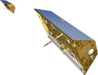
Jason-1 was a satellite altimeter oceanography mission. It sought to monitor global ocean circulation, study the ties between the ocean and the atmosphere, improve global climate forecasts and predictions, and monitor events such as El Niño and ocean eddies. Jason-1 was launched in 2001 and it was followed by OSTM/Jason-2 in 2008, and Jason-3 in 2016 – the Jason satellite series. Jason-1 was launched alongside the TIMED spacecraft.
The Gravity Recovery and Climate Experiment (GRACE) was a joint mission of NASA and the German Aerospace Center (DLR). Twin satellites took detailed measurements of Earth's gravity field anomalies from its launch in March 2002 to the end of its science mission in October 2017. The two satellites were sometimes called Tom and Jerry, a nod to the famous cartoon. The GRACE Follow-On (GRACE-FO) is a continuation of the mission on near-identical hardware, launched in May 2018. On March 19, 2024, NASA announced that the successor to GRACE-FO would be Gravity Recovery and Climate Experiment-Continuity (GRACE-C), to be launched in or after 2028.

TOPEX/Poseidon was a joint satellite altimeter mission between NASA, the U.S. space agency; and CNES, the French space agency, to map ocean surface topography. Launched on August 10, 1992, it was the first major oceanographic research satellite. TOPEX/Poseidon helped revolutionize oceanography by providing data previously impossible to obtain. Oceanographer Walter Munk described TOPEX/Poseidon as "the most successful ocean experiment of all time." A malfunction ended normal satellite operations in January 2006.
A scatterometer or diffusionmeter is a scientific instrument to measure the return of a beam of light or radar waves scattered by diffusion in a medium such as air. Diffusionmeters using visible light are found in airports or along roads to measure horizontal visibility. Radar scatterometers use radio or microwaves to determine the normalized radar cross section of a surface. They are often mounted on weather satellites to find wind speed and direction, and are used in industries to analyze the roughness of surfaces.

OSTM/Jason-2, or Ocean Surface Topography Mission/Jason-2 satellite, was an international Earth observation satellite altimeter joint mission for sea surface height measurements between NASA and CNES. It was the third satellite in a series started in 1992 by the NASA/CNES TOPEX/Poseidon mission and continued by the NASA/CNES Jason-1 mission launched in 2001.

Edward Carroll Stone is an American space scientist, professor of physics at the California Institute of Technology, and former director of the NASA Jet Propulsion Laboratory (JPL).

The Surface Water and Ocean Topography (SWOT) mission is a satellite altimeter jointly developed and operated by NASA and CNES, the French space agency, in partnership with the Canadian Space Agency (CSA) and UK Space Agency (UKSA). The objectives of the mission are to make the first global survey of the Earth's surface water, to observe the fine details of the ocean surface topography, and to measure how terrestrial surface water bodies change over time.
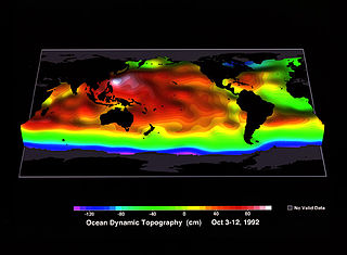
Ocean surface topography or sea surface topography, also called ocean dynamic topography, are highs and lows on the ocean surface, similar to the hills and valleys of Earth's land surface depicted on a topographic map. These variations are expressed in terms of average sea surface height (SSH) relative to Earth's geoid. The main purpose of measuring ocean surface topography is to understand the large-scale ocean circulation.

Soil Moisture Active Passive (SMAP) is a NASA environmental monitoring satellite that measures soil moisture across the planet. It is designed to collect a global 'snapshot' of soil moisture every 2 to 3 days. With this frequency, changes from specific storms can be measured while also assessing impacts across seasons of the year. SMAP was launched on 31 January 2015. It was one of the first Earth observation satellites developed by NASA in response to the National Research Council's Decadal Survey.

Eric J. Rignot is the Donald Bren, Distinguished and Chancellor Professor of Earth system science at the University of California, Irvine, and a Senior Research Scientist for the Radar Science and Engineering Section at NASA's Jet Propulsion Laboratory. He studies the interaction of the polar ice sheets in Greenland and Antarctica with global climate using a combination of satellite remote sensing, airborne remote sensing, understanding of physical processes controlling glacier flow and ice melt in the ocean, field methods, and climate modeling. He was elected at the National_Academy_of_Sciences in 2018.
Frank Wentz is the CEO and director of Remote Sensing Systems, a company he founded in 1974, which specializes in satellite microwave remote sensing research. Together with Carl Mears, he is best known for developing a satellite temperature record from MSU and AMSU. Intercomparison of this record with the earlier UAH satellite temperature record, developed by John Christy and Roy Spencer, revealed deficiencies in the earlier work; specifically, the warming trend in the RSS version is larger than the University of Alabama in Huntsville (UAH) one. From 1978 to 1982, Wentz was a member of NASA's SeaSat Experiment Team involved in the development of physically based retrieval methods for microwave scatterometers and radiometers. He has also investigated the effect of climate change on satellite-derived evaporation, precipitation and surface wind values. His findings are different from most climate change model predictions.

Joshua K. Willis is an oceanographer at NASA's Jet Propulsion Laboratory. His area of expertise is current sea level rise, as well as measuring ocean temperatures. When sea level fell from 2010 to 2011, Willis stated that this was due to an unusually large La Niña transferring more rainfall over land rather than over the ocean as usually happens. In addition, Willis is the project scientist for Jason-3.
George Henry Born was an American aerospace engineer, Distinguished Professor, founder and Director Emeritus of the Colorado Center for Astrodynamics Research (CCAR) at the University of Colorado Boulder. He is known for his work in satellite navigation and precise orbit determination. He worked on various missions while at the Jet Propulsion Laboratory as well as navigation support for the Apollo program in the late 1960s while at Johnson Space Center.
Lew Allen Award for Excellence is a medal of the Jet Propulsion Laboratory. Established in 1986 as the Director’s Research Achievement Award; it was then renamed in honor of JPL's Director Lew Allen when he retired in 1990. This award recognizes significant accomplishments or leadership early in an individual's professional career at the Jet Propulsion Laboratory.

The Sentinel-6 Michael Freilich (S6MF) or Sentinel-6A is a radar altimeter satellite developed in partnership between several European and American organizations. It is part of the Jason satellite series and is named after Michael Freilich. S6MF includes synthetic-aperture radar altimetry techniques to improve ocean topography measurements, in addition to rivers and lakes. The spacecraft entered service in mid 2021 and is expected to operate for 5.5 years.

Michael H. Freilich was an American oceanographer who served as director of the NASA Earth Science division from 2006–2019.

Eni G. Njoku is a Nigerian-American scientist specializing in microwave remote sensing. He worked at the Jet Propulsion Laboratory (JPL), California Institute of Technology, where he was responsible for developing techniques for sea surface temperature and soil moisture remote sensing using microwave radiometers. He produced the first microwave-derived sea surface temperature maps from space, and developed the first application of deployable mesh antennas for satellite Earth observation. From 2008-2013, he served as project scientist of NASA's first soil moisture mission, the Soil Moisture Active Passive (SMAP) mission, launched in 2015.
Moustafa T. Chahine was an atmospheric scientist and an international leader in atmospheric remote sensing using satellite observations. He was the Science Team Leader for the Atmospheric Infrared Sounder on NASA's Earth Observing System Aqua satellite, and the Chairman of the Global Energy and Water Exchanges (GEWEX) Science Steering Group of the World Climate Research Program (WCRP).