Wide Area Information Server (WAIS) is a client–server text searching system that uses the ANSI Standard Z39.50 Information Retrieval Service Definition and Protocol Specifications for Library Applications" (Z39.50:1988) to search index databases on remote computers. It was developed in 1990 as a project of Thinking Machines, Apple Computer, Dow Jones, and KPMG Peat Marwick.

The European Geostationary Navigation Overlay Service (EGNOS) is a satellite based augmentation system (SBAS) developed by the European Space Agency and EUROCONTROL on behalf of the European Commission. Currently, it supplements the GPS by reporting on the reliability and accuracy of their positioning data and sending out corrections. The system will supplement Galileo in a future version.
Bonjour is Apple's implementation of zero-configuration networking (zeroconf), a group of technologies that includes service discovery, address assignment, and hostname resolution. Bonjour locates devices such as printers, other computers, and the services that those devices offer on a local network using multicast Domain Name System (mDNS) service records.

The Wide Area Augmentation System (WAAS) is an air navigation aid developed by the Federal Aviation Administration to augment the Global Positioning System (GPS), with the goal of improving its accuracy, integrity, and availability. Essentially, WAAS is intended to enable aircraft to rely on GPS for all phases of flight, including precision approaches to any airport within its coverage area. It may be further enhanced with the Local Area Augmentation System (LAAS) also known by the preferred ICAO term Ground-Based Augmentation System (GBAS) in critical areas.
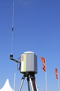
A Differential Global Positioning System (DGPS) is an enhancement to the Global Positioning System (GPS) which provides improved location accuracy, in the range of operations of each system, from the 15-meter nominal GPS accuracy to about 1–3 cm in case of the best implementations.
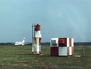
The microwave landing system (MLS) is an all-weather, precision radio guidance system intended to be installed at large airports to assist aircraft in landing, including 'blind landings'. MLS enables an approaching aircraft to determine when it is aligned with the destination runway and on the correct glidepath for a safe landing. MLS was intended to replace or supplement the instrument landing systems (ILS). MLS has a number of operational advantages over ILS, including a wider selection of channels to avoid interference with nearby installations, excellent performance in all weather, a small "footprint" at the airports, and wide vertical and horizontal "capture" angles that allowed approaches from wider areas around the airport.
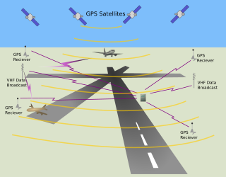
The local-area augmentation system (LAAS) is an all-weather aircraft landing system based on real-time differential correction of the GPS signal. Local reference receivers located around the airport send data to a central location at the airport. This data is used to formulate a correction message, which is then transmitted to users via a VHF Data Link. A receiver on an aircraft uses this information to correct GPS signals, which then provides a standard ILS-style display to use while flying a precision approach. The FAA has stopped using the term LAAS and has transitioned to the International Civil Aviation Organization (ICAO) terminology of Ground-Based Augmentation System (GBAS). While the FAA has indefinitely delayed plans for federal GBAS acquisition, the system can be purchased by airports and installed as a Non-Federal navigation aid.
iQue was a line of Garmin devices which combined personal digital assistants (PDA) with integrated Global Positioning System (GPS) receivers. It was discontinued by mid-2008.
StarFire is a wide-area differential GPS developed by John Deere's NavCom and precision farming groups. StarFire broadcasts additional "correction information" over satellite L-band frequencies around the world, allowing a StarFire-equipped receiver to produce position measurements accurate to well under one meter, with typical accuracy over a 24-hour period being under 4.5 cm. StarFire is similar to the FAA's differential GPS Wide Area Augmentation System (WAAS), but considerably more accurate due to a number of techniques that improve its receiver-end processing.
Multi-functional Satellite Augmentation System is a Japanese satellite based augmentation system (SBAS), i.e. a satellite navigation system which supports differential GPS (DGPS) to supplement the GPS system by reporting on the reliability and accuracy of those signals. MSAS is operated by Japan's Ministry of Land, Infrastructure and Transport and Civil Aviation Bureau (JCAB). Tests have been accomplished successfully, MSAS for aviation use was commissioned on 27 September 2007.

Augmentation of a global navigation satellite system (GNSS) is a method of improving the navigation system's attributes, such as accuracy, reliability, and availability, through the integration of external information into the calculation process. There are many such systems in place and they are generally named or described based on how the GNSS sensor receives the external information. Some systems transmit additional information about sources of error, others provide direct measurements of how much the signal was off in the past, while a third group provides additional vehicle information to be integrated in the calculation process.
The World Academy of Art and Science (WAAS) is an international non-governmental scientific organization, a world network of more than 700 individual fellows from more than 80 countries. Fellows are elected for distinguished accomplishments in the sciences, arts and the humanities. The Academy strives to promote the growth of knowledge, enhance public awareness of the social consequences and policy implications of that growth, and provide "leadership in thought that leads to action". The spirit of the academy can be expressed in the words of Albert Einstein "The creations of our mind shall be a blessing and not a curse to mankind".
The Capstone Program was a United States government-funded aviation safety program for the state of Alaska, primarily focusing on rural areas of the state. This joint effort – between the Federal Aviation Administration (FAA), the Alaska Pilot's Association, commercial operators, the University of Alaska, MITRE Corporation, some avionics manufacturers and individual pilots – cut the accident rate in the eastern part of Alaska by around 40%.
Cisco Wide Area Application Services (WAAS) is technology developed by Cisco Systems that optimizes the performance of any TCP-based application operating in a wide area network (WAN) environment while preserving and strengthening branch security. WAAS combines WAN optimization, acceleration of TCP-based applications, and Cisco's Wide Area File Services (WAFS) in a single appliance or blade. It is Cisco's attempt to keep WAN optimization residing firmly in the router, eliminating the need to deploy acceleration appliances throughout the infrastructure. The technology preserves TCP information within the network while offering the performance benefits that come along with using WAN optimization technology.
Localizer performance with vertical guidance (LPV) are the highest precision GPS aviation instrument approach procedures currently available without specialized aircrew training requirements, such as required navigation performance (RNP). Landing minima are usually similar to those of a Cat I instrument landing system (ILS), that is, a decision height of 200 feet (61 m) and visibility of 800 m. Lateral guidance is equivalent to a localizer, and uses a ground-independent electronic glide path. Thus, the Decision Altitude, DA, can be as low as 200 feet. An LPV approach is an approach with vertical guidance, APV, to distinguish it from a precision approach, PA, or a non-precision approach, NPA. WAAS criteria includes a vertical alarm limit more than 12 m, but less than 50 m, yet an LPV does not meet the ICAO Annex 10 precision approach standard.

St. George's Catholic Church is a historic church and school building on Vermont Route 25 in Bakersfield, Vermont. Built in 1840, it housed the South Academy until 1888, when it was purchased by the Roman Catholic Diocese of Burlington. It served as a church until 1996, and has since then housed the local historical society. It is a prominent local example of Gothic Revival architecture, and was listed on the National Register of Historic Places in 2001.
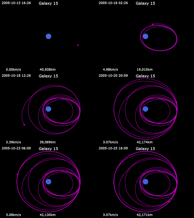
Galaxy 15 is an American telecommunications satellite which is owned by Intelsat. It was launched for and originally operated by PanAmSat, and was subsequently transferred to Intelsat when the two companies merged in 2006. It was originally positioned in geostationary orbit at a longitude of 133° West, from where it was used to provide communication services to North America. In April 2010, Intelsat lost control of the satellite, and it began to drift away from its orbital slot, with the potential to cause disruption to other satellites in its path.
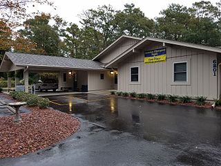
Wilmington Academy of Arts and Sciences (WAAS) is a private school in Wilmington, North Carolina that focuses on education for academically gifted students in grades 4-8.
CALSTAR is a 501(c)(3) nonprofit regional air medical services company serving California and northern Nevada. It is currently the largest nonprofit air ambulance provider on the West Coast.


