The World Meteorological Organization (WMO) is a specialized agency of the United Nations responsible for promoting international cooperation on atmospheric science, climatology, hydrology and geophysics.

The Organisation of Islamic Cooperation, formerly the Organisation of the Islamic Conference, is an intergovernmental organization founded in 1969, consisting of 57 member states, with 48 being Muslim-majority countries. The organisation states that it is "the collective voice of the Muslim world" and works to "safeguard and protect the interests of the Muslim world in the spirit of promoting international peace and harmony".

Tropical cyclones and subtropical cyclones are named by various warning centers to simplify communication between forecasters and the general public regarding forecasts, watches and warnings. The names are intended to reduce confusion in the event of concurrent storms in the same basin. Once storms develop sustained wind speeds of more than 33 knots, names are generally assigned to them from predetermined lists, depending on the basin in which they originate. Some tropical depressions are named in the Western Pacific; while tropical cyclones must contain a significant amount of gale-force winds before they are named in the Southern Hemisphere.

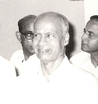
Pisharoth Rama Pisharoty was an Indian physicist and meteorologist, and is considered to be the father of remote sensing in India.

A Regional Specialized Meteorological Centre (RSMC) is responsible for the distribution of information, advisories, and warnings regarding the specific program they have a part of, agreed by consensus at the World Meteorological Organization as part of the World Weather Watch.
The Estonian Weather Service is the Estonian national meteorological service.
CLIMAT is a code for reporting monthly climatological data assembled at land-based meteorological surface observation sites to data centres. CLIMAT-coded messages contain information on several meteorological variables that are important to monitor characteristics, changes, and variability of climate. Usually these messages are sent and exchanged via the Global Telecommunication System (GTS) of the World Meteorological Organisation (WMO). Modifications of the CLIMAT code are the CLIMAT SHIP and CLIMAT TEMP / CLIMAT TEMP SHIP codes which serve to report monthly climatological data assembled at ocean-based meteorological surface observation sites and at land-/ocean-based meteorological upper-air observation sites, respectively. The monthly values included usually are obtained by averaging observational values of one or several daily observations over the respective month.
Cartosat-2B is an Earth observation satellite in a Sun-synchronous orbit and the fourth of the Cartosat series of satellites. The satellite is the seventeenth satellite in the Indian Remote Sensing (IRS) satellite series to be built by the Indian Space Research Organisation (ISRO).

Anna Mani was an Indian physicist and meteorologist. She retired as the Deputy Director General of the Indian Meteorological Department and also served as a visiting professor at the Raman Research Institute. Mani made contributions to the field of meteorological instrumentation, conducted research, and published numerous papers on solar radiation, ozone, and wind energy measurements.
IRS-P2 was an Earth observation satellite launched under the National Natural Resources Management System (NNRMS) programme undertaken by Indian Space Research Organisation (ISRO). The objectives of the mission were to provide spaceborne capability to India in observing and managing natural resources and utilizing them in a productive manner. The satellite carried imaging multi-spectral radiometers on board for radio sensing of the resources.
IRS-1E was an Earth observation mission launched under the National Natural Resources Management System (NNRMS) programme by Indian Space Research Organisation (ISRO). Sometimes written IRS-P1. The objective of the mission was to develop Earth imagery using instruments carried on board. Due to a malfunction of the launch vehicle, the satellite deviated from its path and plunged into the Indian Ocean.
The Indian Radio Regulatory Service (IRRS) is one of the cadre of central government recruit-engineers of the Wireless Planning & Coordination Wing (WPC) and Wireless Monitoring Organisation (WMO), composed of a cadre of central government recruit engineers Group 'A' officers of the WPC and WMO. There are a total of 22 Wireless Monitoring Stations, 5 International Monitoring Stations and 1 International Satellite Monitoring Earth Station in India, The functions of the service are the allocation of spectrum licenses, ensuring an interference free spectrum to wireless users, conducting GMDSS and RTR (Aero) examination, SACFA clearances to Telecom service Providers, ensuring adherence to international standards and cooperation with the International Telecommunication Union (ITU). The Government of India established the service by a gazette notification on 16 July 2013. The Wireless Adviser to the Government of India is the highest officer in the service's hierarchy and reports to the Member (Technology) of Telecom Commission of India under the Department of Telecommunications.
The Wireless Monitoring Organisation (WMO), set up in 1952, is responsible for monitoring all wireless transmissions and is essentially the eyes and ears of the Wireless Planning & Coordination Wing (WPC) in the Ministry of Communications of the Government of India. Its primary task is to monitor the entire radio frequency spectrum with a view to provide the requisite technical data logistic support to the WPC Wing in the enforcement of the National and International Radio Regulatory and statutory provisions for efficient management of Radio Frequency Spectrum and Geo-Stationary Orbit. This is in the interest of vital national service which, though not revenue bearing, yields considerable indirect benefits through promoting the efficient utilisation of the radio frequency spectrum and the geostationary orbit.

World Meteorological Day was established in 1961 to commemorate the World Meteorological Organization creation on 23 March 1950. This organization announces a slogan for World Meteorology Day every year, and this day is celebrated in all member countries.
The International Meteorological Organization Prize is awarded annually by the World Meteorological Organization (WMO) for outstanding contributions in the field of meteorology and, since 1971, the field of operational hydrology.
World Mime Organisation was officially registered on January 4, 2004 in Belgrade, Serbia. WMO is a non-governmental, non-profit organization founded with the mission to further develop and promote the art of mime and non-verbal communication. World Mime Organisation does not emphasis any mime techniques or styles nor teaching, accepting that all organized effort, knowledge and expression should be respected and should find its audience.

Cartosat-2F is the eighth satellite in the Cartosat-2 Series. It is an Earth observation satellite launched on the PSLV-C40 mission by the Indian Space Research Organisation (ISRO).

Sue Barrell was Chief Scientist at the Bureau of Meteorology (BoM). In 2013 she was awarded a Fellow of the Academy of Technology and Engineering (FTSE). In 2018, Barrell was elected Vice President of Science and Technology Australia. Amongst other topics, she has worked on international science policy climate monitoring, research and policy, and ocean–earth observations. Barrell was the first female meteorologist to join the senior Executive team of the BoM. She was the first female elected to leadership of a WMO Technical Commission and was one of the early female forecasters.
Joseph Lasiri is an Italian Muay Thai fighter. He is currently signed to ONE Championship, where he is the reigning ONE Strawweight Muay Thai World Champion.


