Related Research Articles
MediaWiki is free and open-source wiki software originally developed by Magnus Manske for use on Wikipedia on January 25, 2002, and further improved by Lee Daniel Crocker, after which it has been coordinated by the Wikimedia Foundation. It powers several wiki hosting websites across the Internet, as well as most websites hosted by the Wikimedia Foundation including Wikipedia, Wiktionary, Wikimedia Commons, Wikiquote, Meta-Wiki and Wikidata, which define a large part of the set requirements for the software. MediaWiki is written in the PHP programming language and stores all text content into a database. The software is optimized to efficiently handle large projects, which can have terabytes of content and hundreds of thousands of views per second. Because Wikipedia is one of the world's largest and most visited websites, achieving scalability through multiple layers of caching and database replication has been a major concern for developers. Another major aspect of MediaWiki is its internationalization; its interface is available in more than 400 languages. The software has more than 1,000 configuration settings and more than 1,800 extensions available for enabling various features to be added or changed. Besides its usage on Wikimedia sites, MediaWiki has been used as a knowledge management and content management system on websites such as Fandom, wikiHow and major internal installations like Intellipedia and Diplopedia.
A geocode is a code that represents a geographic entity. It is a unique identifier of the entity, to distinguish it from others in a finite set of geographic entities. In general the geocode is a human-readable and short identifier.
Pay-per-click (PPC) is an internet advertising model used to drive traffic to websites, in which an advertiser pays a publisher when the ad is clicked.
Yahoo! Maps was a free online mapping portal provided by Yahoo! Functionality included local weather powered by The Weather Channel, printing maps, and local reviews powered by Yelp. It shut down on June 30, 2015. For a time in 2019, Yahoo! Maps could be accessed in the United States on https://search.yahoo.com/, albeit powered by Here WeGo. However, that is no longer possible.
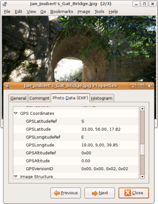
Geotagging, or GeoTagging, is the process of adding geographical identification metadata to various media such as a geotagged photograph or video, websites, SMS messages, QR Codes or RSS feeds and is a form of geospatial metadata. This data usually consists of latitude and longitude coordinates, though they can also include altitude, bearing, distance, accuracy data, and place names, and perhaps a time stamp.

A hackathon is an event where people engage in rapid and collaborative engineering over a relatively short period of time such as 24 or 48 hours. They are often run using agile software development practices, such as sprint-like design wherein computer programmers and others involved in software development, including graphic designers, interface designers, product managers, project managers, domain experts, and others collaborate intensively on engineering projects, such as software engineering.
XWiki is a free and Open source wiki software platform written in Java with a design emphasis on extensibility. XWiki is an enterprise wiki. It includes WYSIWYG editing, OpenDocument-based document import/export, annotations and tagging, and advanced permissions management.
Microformats (μF) are a set of defined HTML classes created to serve as consistent and descriptive metadata about an element, designating it as representing a certain type of data. They allow software to process the information reliably by having set classes refer to a specific type of data rather than being arbitrary.
Catalyst is an open-source web application framework written in Perl. It closely follows the model–view–controller (MVC) architecture and supports a number of experimental web patterns. It is written using Moose, a modern object system for Perl. Its design is heavily inspired by frameworks such as Ruby on Rails, Maypole, and Spring.
OpenStreetMap (OSM) is a free, open geographic database updated and maintained by a community of volunteers via open collaboration. Contributors collect data from surveys, trace from aerial imagery and also import from other freely licensed geodata sources. OpenStreetMap is freely licensed under the Open Database License and as a result commonly used to make electronic maps, inform turn-by-turn navigation, assist in humanitarian aid and data visualisation. OpenStreetMap uses its own topology to store geographical features which can then be exported into other GIS file formats. The OpenStreetMap website itself is an online map, geodata search engine and editor.

Java Unified Mapping Program (JUMP) is a Java based vector and raster GIS and programming framework. Current development continues under the OpenJUMP name.
Semantic MediaWiki (SMW) is an extension to MediaWiki that allows for annotating semantic data within wiki pages, thus turning a wiki that incorporates the extension into a semantic wiki. Data that has been encoded can be used in semantic searches, used for aggregation of pages, displayed in formats like maps, calendars and graphs, and exported to the outside world via formats like RDF and CSV.
The following tables compare general and technical information for a number of current, notable video hosting services. Please see the individual products' articles for further information.
Google Developers is Google's site for software development tools and platforms, application programming interfaces (APIs), and technical resources. The site contains documentation on using Google developer tools and APIs—including discussion groups and blogs for developers using Google's developer products.
A sandbox is a testing environment that isolates untested code changes and outright experimentation from the production environment or repository in the context of software development, including web development, automation, revision control, configuration management, and patch management.

GeoNames is a user-editable geographical database available and accessible through various web services, under a Creative Commons attribution license. The project was founded in late 2005.
Random Hacks of Kindness (RHoK) is a global community of technologists dedicated to solving problems for charities, non-profits and social enterprises by organising recurring hackathons that has existed since 2009. The organisation currently has a presence in over 20 cities throughout 5 continents, and had 2000 participants in 2017.
Schema.org is a reference website that publishes documentation and guidelines for using structured data mark-up on web-pages. Its main objective is to standardize HTML tags to be used by webmasters for creating rich results about a certain topic of interest. It is a part of the semantic web project, which aims to make document mark-up codes more readable and meaningful to both humans and machines.
GeoPlanet is a computer platform for coordinating world-wide geographic information, and providing both text and cartographic output, such as digital maps for any location in the world. It provides a location infrastructure for search engines, portals and both Web and WAP sites. It was developed by GDC, a London-based geographic information company, which was acquired by Whereonearth in 1998. When Whereonearth spun off GDC in 2002, it kept GeoPlanet. When Yahoo! purchased Whereonearth in 2005, it acquired GeoPlanet.
References
- ↑ "Yahoo! WOEID Lookup". Zourbuth Project.
- ↑ "Free geo data solutions compared: GeoNames.org vs. Yahoo! GeoPlanet". Cosmo Code. 24 January 2010.
- ↑ "Yahoo! GeoPlanet™ Data". Yahoo!. Archived from the original on 22 August 2014. Retrieved 25 June 2014.
- ↑ "Flickr Services: Flickr API: flickr.places.getInfo". www.flickr.com. Retrieved 2016-05-01.
- ↑ "Key:woeid - OpenStreetMap Wiki". wiki.openstreetmap.org. Retrieved 2016-05-01.
- ↑ "Twitter Developer Documentation". developer.twitter.com. Retrieved 2019-01-08.
- ↑ "WOEID Search Engine (archive link)" originally findmycity.com
- ↑ "Free geo data solutions compared: GeoNames.org vs. Yahoo! GeoPlanet - CosmoCode GmbH". www.cosmocode.de. Archived from the original on 2010-01-27.