Related Research Articles
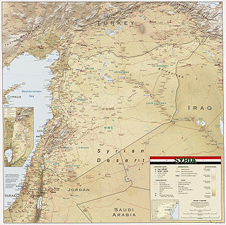
Syria is located in West Asia, north of the Arabian Peninsula, at the eastern end of the Mediterranean Sea. It is bordered by Turkey to the north, Lebanon and Israel to the west and southwest, Iraq to the east, and Jordan to the south. It consists of mountain ranges in the west and a steep area inland. In the east is the Syrian Desert and in the south is the Jabal al-Druze Range. The former is bisected by the Euphrates valley. A dam built in 1973 on the Euphrates created a reservoir named Lake Assad, the largest lake in Syria. The highest point in Syria is Mount Hermon on the Lebanese border at 2,814 metres or 9,232 feet. Between the humid Mediterranean coast and the arid desert regions lies a semiarid steep zone extending across three-quarters of the country, which receives hot, dry winds blowing across the desert. Syria is extensively depleted, with 28 percent of the land arable, 4 percent dedicated to permanent crops, 46 percent utilized as meadows and pastures, and only 3 percent forest and woodland.

The Khabur River is the largest perennial tributary to the Euphrates in Syria. Although the Khabur originates in Turkey, the karstic springs around Ras al-Ayn are the river's main source of water. Several important wadis join the Khabur north of Al-Hasakah, together creating what is known as the Khabur Triangle, or Upper Khabur area. From north to south, annual rainfall in the Khabur basin decreases from over 400 mm to less than 200 mm. THis has made the river a vital water source for agriculture throughout history. The Khabur joins the Euphrates near the town of Busayrah.

The Balikh River is a perennial river that originates in the spring of Ain al-Arous near Tell Abyad in the Eastern Mediterranean conifer-sclerophyllous-broadleaf forests ecoregion. It flows due south and joins the Euphrates at the modern city of Raqqa. The Balikh is the second largest tributary to the Euphrates in Syria, after the Khabur River. It is an important source of water and large sections have recently been subjected to canalization.

Tell Abyad District is a district of the Raqqa Governorate in northern Syria. The administrative centre is the city of Tell Abyad. Parts of the district are currently under the Turkish occupation of northern Syria.

Al-Nuqayb was a Palestinian Arab village in the Tiberias Subdistrict. It was depopulated during the 1948 Arab-Israeli War on May 15, 1948. It was located 10 km east across the lake from Tiberias. bordering the Wadi al-Muzaffar and Wadi Samakh. al-Nuqayb was named after the Bedouin tribe of 'Arab al-Nuqayb.
The Sajur is a 108 kilometres (67 mi) long river originating in Turkey and flowing into the Euphrates in Syria. It is the smallest of the three rivers joining the Euphrates in Syria, and the only one that joins the Euphrates on its western bank. Occupation in the Sajur basin started in the Lower Palaeolithic period and continues until today.
The Wadi al-Kheder is a river in Syria. It a tributary of the Balikh River.

Wadi al-'Uyun is a town in northwestern Syria, administratively part of the Hama Governorate, located west of Hama.
Kfeir Alzeit is a village in southern Syria, administratively part of the Rif Dimashq Governorate, located northwest of Damascus in the Wadi Barada. Nearby localities include Ain al-Fijah, Deir Qanun, al-Dimas, Jdeidat al-Wadi, Deir Muqaran and Basimah. According to the Syria Central Bureau of Statistics, Kfeir Alzeit had a population of 4,170 in the 2004 census.
Jdeidat al-Wadi or Jdeidat Wadi Barada is a village adjacent to the town of Qudsaya and just north of the Mezzeh district of Damascus in Syria. The village is administratively part of the Qudsaya District of the Rif Dimashq Governorate in southern Syria. Nearby localities include al-Hamah to the east, Ashrafiyat al-Wadi to the north, the affluent suburbs of al-Sabboura and Yaafour to the west and Dahiyat Qudsaya to the south. According to the Syria Central Bureau of Statistics, Jdeidat al-Wadi had a population of 5,227 in the 2004 census. Its inhabitants are predominantly Sunni Muslims.
Ashrafiyat al-Wadi is a village adjacent to the town of Qudsaya and just north of the Mezzeh district of Damascus in Syria. The village is administratively part of the Qudsaya District of the Rif Dimashq Governorate in southern Syria. Nearby localities include al-Hamah to the east, the affluent suburbs of al-Sabboura and Yaafour to the west and Dahiyat Qudsaya and Jdeidat al-Wadi to the south. According to the Syria Central Bureau of Statistics, Ashrafiyat al-Wadi had a population of 2,101 in the 2004 census. Its inhabitants are predominantly Sunni Muslims.

The siege of Wadi Deif refers to the siege of two Syrian Army bases, Wadi Deif and Hamadiyah, by rebel forces, starting on 11 October 2012, during the Idlib Governorate clashes of the Syrian civil war.
Ain al-Arous is a Syrian village in Tal Abyad District, in Raqqa Governorate, located 3 km south of the city of Tal Abyad, 92 km north of the city of Raqqa, 200 km east of the city of Aleppo and 420 km north of the capital Damascus. It is near the border with Turkey. The Balikh River rises from it.

Souq Wadi Barada also spelled Suq Wadi Barada is a Syrian village in the Al-Zabadani District of the Rif Dimashq Governorate. According to the Syria Central Bureau of Statistics (CBS), Souq Wadi Barada had a population of 3,678 in the 2004 census. Its inhabitants are predominantly Sunni Muslims.
Al-Sindiyana is a Syrian village located in Wadi al-Uyun Nahiyah in Masyaf District, Hama. According to the Syria Central Bureau of Statistics (CBS), al-Sindiyana had a population of 621 in the 2004 census.
The siege of Wadi Deif refers to the siege of two Syrian Army bases, Wadi Deif and Hamadiyah, by rebel forces, during the 2014 Idlib offensive of the Syrian Civil War. The first siege of these two bases was broken by the Syrian Army on 18 April 2013. During the siege, rebels detonated several 'tunnel bombs' underneath army positions surrounding the bases, which was similar to the tactics used during the First World War.

The Wadi Barada offensive (2016–2017) was a military operation against rebel-held villages in the Barada River valley by the Syrian Army and allied forces, including pro-government militias and Lebanese Hezbollah between December 2016 and January 2017. The Barada River valley includes the village of Ain al-Fijah which holds a water spring that provides drinking water to towns throughout the Rif Dimashq Governorate.
Ḥiṣn Maslama was a small city in the upper Balikh River valley that was inhabited during the early Islamic period. It was located at the present-day ruin site of Madīnat al-Fār, located 6 km east of the Balikh river near its junction with the Wadi Hamar. The site consists of a northern enclosure and a southern extension. Originally founded as a rural estate by the Umayyad general Maslama ibn Abd al-Malik in the 700s, it expanded significantly during the Abbasid period and grew into a small city.

al-Jārūd was a small city in the Wadi Hamar area, about 40 km east of the Balikh River in present-day Syria, inhabited during the 9th century. It is identified with Kharāb Sayyār, a ruin covering 42 hectares. The remains of its rectangular-shaped fortification with protruding half-round towers are the most prominent feature. At its peak, during the mid-9th century, al-Jarud was a minor regional center situated along a east-west running traffic and trading route and was embedded in a well settled, agricultural landscape. At least 60 contemporary settlements have been identified within a 13 km radius.
References
- ↑ Wossink, Arne (2009). Challenging Climate Change: Competition and Cooperation Among Pastoralists and Agriculturalists in Northern Mesopotamia (c. 3000-1600 BC). Sidestone Press. ISBN 9789088900310.
- ↑ Mulders, M.A. (1969). The arid soils of the Balikh Basin (syria).