Related Research Articles

The Kingdom of Saudi Arabia is a country situated in West Asia, the largest country on the Arabian Peninsula, bordering the Persian Gulf and the Red Sea. Its extensive coastlines provide great leverage on shipping through the Persian Gulf and the Suez Canal. The kingdom occupies 80% of the Arabian Peninsula. Most of the country's boundaries with the United Arab Emirates (UAE), Oman, and the Republic of Yemen are undefined, so the exact size of the country remains unknown. The Saudi government estimate is at 2,217,949 square kilometres, while other reputable estimates vary between 2,149,690 and 2,240,000 sq. kilometres. Less than 7% of the total area is suitable for cultivation, and in the early 1960s, population distribution varied greatly among the towns of the eastern and western coastal areas, the densely populated interior oases, and the vast, almost empty deserts.

Jabal al-Druze, is an elevated volcanic region in the As-Suwayda Governorate of southern Syria. Most of the inhabitants of this region are Druze, and there are also significant Christian communities. Safaitic inscriptions were first found in this area. The State of Jabal Druze was an autonomous area in the French Mandate for Syria and the Lebanon from 1921 to 1936. In the past, the name Jabal al-Druze was used for a different area, located in Mount Lebanon.

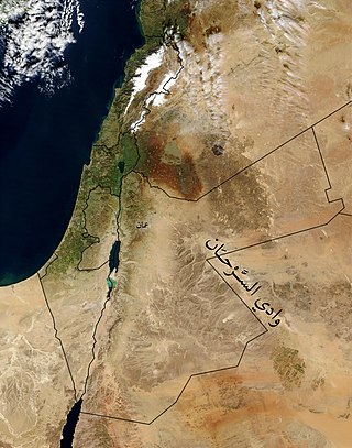
The Syrian Desert, also known as the North Arabian Desert, the Jordanian steppe, or the Badiya, is a region of desert, semi-desert, and steppe, covering approx. 500,000 square kilometers of West Asia, including parts of northern Saudi Arabia, eastern Jordan, southern Syria, and western Iraq. It accounts for approx. 85% of the land area of Jordan and 55% of Syria. To the south, it borders and merges into the Arabian Desert. The land is open, rocky or gravelly desert pavement, cut with occasional wadis.
The Limes Arabicus was a desert frontier of the Roman Empire, running north from its start in the province of Arabia Petraea. It ran northeast from the Gulf of Aqaba for about 1,500 kilometers (930 mi) at its greatest extent, reaching northern Syria and forming part of the wider Roman limes system. It had several forts and watchtowers.

Qasr Harrana, sometimes Qasr al-Kharana, Harana, Qasr al-Harrana, Qasr al-Haranah, Haraneh, Khauranee, or Hraneh, is one of the best-known of the desert castles located in present-day eastern Jordan, about 60 kilometres (37 mi) east of Amman and relatively close to the border with Saudi Arabia. It is uncertain when the palace was constructed, but it likely originates from the Umayyad Dynasty. An inscription on an upper wall dates the building to before 710 CE. A Greek or Byzantine house may have existed on the site. The purpose of the building is a subject of debate among scholars. Theories as to the qasr's purpose include a Crusader's castle, a military stronghold, agricultural outpost, and resting place for caravan travelers. The current scholarly consensus is that the building was used as for meeting between local Bedouin leaders.

Azraq is a small town in Zarqa Governorate in central-eastern Jordan, 100 kilometres (62 mi) east of Amman. The population of Azraq was 9,021 in 2004. The Muwaffaq Salti Air Base is located in Azraq.
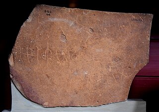
Safaitic is a variety of the South Semitic scripts used by the Arabs in southern Syria and northern Jordan in the Ḥarrah region, to carve rock inscriptions in various dialects of Old Arabic and Ancient North Arabian. The Safaitic script is a member of the Ancient North Arabian (ANA) sub-grouping of the South Semitic script family, the genetic unity of which has yet to be demonstrated.
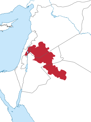
Jordan is a sovereign Arab state in the Middle East. The capital, Amman, is Jordan's most populous city as well as the country's economic, political and cultural centre.
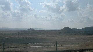
The Ḥarrat al-Shām, also known as the Black Desert, is a region of rocky, basaltic desert straddling southern Syrian region and the northern Arabian Peninsula. It covers an area of some 40,000 km2 (15,000 sq mi) in the modern-day Syrian Arab Republic, Jordan, Israel and Saudi Arabia. Vegetation is characteristically open acacia shrubland with patches of juniper at higher altitudes.

The desert castles or qasrs are often called Umayyad desert castles, since the vast majority of these fortified palaces or castles were built by the Umayyad Dynasty in their province of Bilad ash-Sham, with very few Abbasid exceptions. The desert castles of Jordan represent a prominent part of this group of buildings, with most Umayyad "desert castles" being scattered over the semi-arid regions of north-eastern Jordan, with several more in Syria, Israel and the West Bank (Palestine), and just one Abbasid exception in Iraq.

The Azraq Wetland Reserve is a nature reserve located in the town of Azraq in the eastern desert of Jordan. An oasis for migratory birds, the reserve was established in 1978 and covers 12 square kilometres (4.6 sq mi). The natural springs dried up in 1992 and most migratory birds subsequently moved away from the area. Artificial springs are maintained today in order to keep the site a tourist destination.
Northwest Arabian Arabic is a proposed subfamily of Arabic encompassing the traditional Bedouin dialects of the Sinai Peninsula, the Negev, Gaza Strip, southern Jordan, and the northwestern corner of Saudi Arabia.

There are at least seven nature reserves in Jordan. In 1966, the organization that would later start Jordan's nature reserves, the Royal Society for the Conservation of Nature, was founded. RSCN's first efforts involved bringing back severely endangered species. In 1973, RSCN, was given the right to issue hunting licenses, giving RSCN an upper hand in preventing extinction. The first step was the founding of Jordan's first nature reserve, Shaumari Wildlife Reserve, in 1975. The primary purpose was to create means to breed endangered species, specifically: the Arabian oryx, gazelles, ostriches and Persian onagers in their natural environment.
William Osbert Lancaster was a British social anthropologist who specialised in the study of the Arab world, particularly the bedouin tribes in the Levant and Middle East.
Wadi al-Taym, also transliterated as Wadi el-Taym, is a wadi that forms a large fertile valley in Lebanon, in the districts of Rachaya and Hasbaya on the western slopes of Mount Hermon. It adjoins the Beqaa Valley running north to south towards the Jordan Valley where it meets the northwest corner of Lake Huleh. Watered by the Hasbani river, the low hills of Wadi al-Taym are covered with rows of silver-green olive trees with the population in the area being predominantly Druze and Sunni, with a high number of Christians, mostly Greek Orthodox. Wadi al-Taym is generally considered the "birthplace of the Druze faith".
Wadi Sirhan is a wide depression in the northwestern Arabian Peninsula. It runs from the Aljouf Oasis in Saudi Arabia northwestward into Jordan. It historically served as a major trade and transportation route between Syria and Arabia. From antiquity until the early 20th century, control of Wadi Sirhan was often contested by various Arab tribes. The valley is named after the Sirhan tribe which migrated there in the mid-17th century.
Wadi Jilat is a seasonal stream (wadi) in the Badia of eastern Jordan. Part of its course runs through a steeply-incised ravine that retains water for much of the year, an unusual feature in the desert region.

Qasr Burqu' is a set of ruins and an archaeological site in the badia of eastern Jordan and is the site of one of the earliest of the Umayyad desert castles.
The geology of Saudi Arabia includes Precambrian igneous and metamorphic basement rocks, exposed across much of the country. Thick sedimentary sequences from the Phanerozoic dominate much of the country's surface and host oil.
The Mesopotamian shrub desert is a deserts and xeric shrublands ecoregion in Western Asia. It extends across portions of Israel, Jordan, Syria, Iraq, and Iran.
References
- ↑ Betts, Alison (1982). "A Natufian site in the Black Desert, Eastern Jordan". Paléorient. 8 (2): 79–82. doi:10.3406/paleo.1982.4322.
- ↑ "Availability of Surface Water of Wadi Rajil as a Source of Groundwater Artificial Recharge: A Case Study of Eastern Badia /Jordan". Current World Environment. 8 (2). 2013-08-31.
- ↑ Field, Henry (1933). "The Antiquity of Man in Southwestern Asia". American Anthropologist. 35 (1): 51–62. doi: 10.1525/aa.1933.35.1.02a00040 . ISSN 0002-7294. JSTOR 662362.
| | This Jordanian location article is a stub. You can help Wikipedia by expanding it. |