Wadi Tuwa | |
|---|---|
 Wadi Tuwa | |
| Coordinates: 25°01′15″N56°07′32.5″E / 25.02083°N 56.125694°E | |
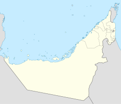
| Country | United Arab Emirates |
| Emirate | Ras Al Khaimah |
| Elevation | 401 m (1,318 ft) |
Wadi Tuwa is a wadi, a seasonal waterway, in the Hajar Mountains of Ras Al Khaimah, United Arab Emirates. The wadi is dammed by the Wadi Tuwa Dam.
A popular spot with campers and hikers, [1] Wadi Tuwa is a fertile wadi with many traditional farms dotted throughout its course. Crops cultivated in the wadi include mangoes, dates, onions and tobacco, [2] watered by a number of wells throughout its southeasterly course. [3]
There are a number of petroglyphs, or rock carvings, to be found throughout the wadi, including distinctive leopards, camels, mounted men and horses. These are of a type found in the region, in the Wadi Ejili, Wadi Khadra and Wadi Shawka in particular. [4]
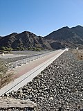 The dam across Wadi Tuwa
 Wadi Tuwa looking up-wadi from the dam

