Notes
27°30′N14°11′E / 27.500°N 14.183°E
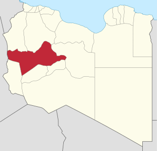
The Wadi ash-Shati' (Wadi ash Shatti) is a valley in west-central Libya, arising out of the Sawda Mountains, situated between the towns Wanzarik and Umm al-'Abid in the west and east, respectively. It is known for iron ore and manganese deposits. [1]
27°30′N14°11′E / 27.500°N 14.183°E
Halfaya Pass is in northwest Egypt, 11.5 kilometres east of the border with Libya and 7.5 kilometres south of the other, more major pass in the ridge today. A 600 feet (180 m) high, narrow escarpment extends south then southeastwards for a total of 55 kilometres (34 mi) from a short distance east of the border. It hems in east-facing small harbour town of as-Salum, continuing as an east-facing sea cliff further north. Land to the east is lower than that to the west and the east side has steep slopes.
Brak (sometimes written Biraq or Birak is a town in the Wadi al Shatii District in west-central Libya. It is the administrative center of the district.

Ghadames or Ghadamis was a district of Libya until 2007. Its territory is now part of Nalut District. It was in the northwest of the country with its capital at Ghadames.

Sabha is one of the districts of Libya, situated near the center of the country in the Fezzan region. The city of Sabha serves as its capital. The district shares borders with the following districts: Wadi Al Shatii to the north, Al Jufrah to the east, Murzuq to the south, and Wadi Al Hayaa to the west.

Fezzan is the southwestern region of modern Libya. It is largely desert, but broken by mountains, uplands, and dry river valleys (wadis) in the north, where oases enable ancient towns and villages to survive deep in the otherwise inhospitable Sahara Desert. The term originally applied to the land beyond the coastal strip of Africa proconsularis, including the Nafusa and extending west of modern Libya over Ouargla and Illizi. As these Berber areas came to be associated with the regions of Tripoli, Cirta or Algiers, the name was increasingly applied to the arid areas south of Tripolitania.

The Jebel Akhdar is a heavily forested, fertile upland area in northeastern Libya. It is located in the modern shabiyahs or districts of Derna, Jabal al Akhdar, and Marj.

Derna is a port city in eastern Libya. With a population of around 85,000 to 90,000, Derna was once the seat of one of the wealthiest provinces among the Barbary States. The city is now the administrative capital of Derna District, which covers a much smaller area than the old province. Among Libyan cities, Derna has a unique location and physical environment, as it lies between Jebel Akhdar, the Mediterranean Sea, and the desert. The city is also home to people of many different backgrounds.

The Quds Governorate, also Jerusalem Governorate, is one of the 16 Governorates of Palestine and located in the central part of the West Bank. The current Governor, appointed by the Palestinian National Authority, is Adnan Ghaith since 2018, who succeeded to Adnan al-Husayni, appointed in 2008. The Governorate has two sub-districts: Jerusalem J1, which includes the localities within the territory controlled by the Israeli Jerusalem municipality, and Jerusalem J2, which includes the remaining parts of the Jerusalem Governorate. The district capital of the Governorate is East Jerusalem (al-Quds).

Mizda was one of the districts of Libya. In the 2007 reorganization of Libyan districts its territory became part of Jabal al Gharbi District.

Wadi al Hayaa is one of the districts of Libya. Its capital is the city of Ubari. As of 2006, it had a population of 72,587, area of 31,890 square kilometres (12,310 sq mi) and a population density of 2.28 persons per square kilometer.

Wadi al Shati, sometimes referred to as Ashati, is one of the districts of Libya in the central-west part of the country. The area is mostly desert. Wadi al Shati District is named after the depression of the same name, Wadi Ashati.

Bouchegouf is a town and district in Guelma Province, Algeria.

Wadi el Kuf Bridge, is a bridge located 20 km west of Bayda, Libya. It is the second highest bridge in Africa.

The Action of Agagia took place east of Sidi Barrani in Egypt on 26 February 1916, during the Senussi Campaign between German and Ottoman-instigated Senussi forces and the British army in Egypt. On 11 December 1915, a British column had been attacked at Duwwar Hussein along the Matruh–Sollum track. In the Affair of Wadi Senba, the Senussi were defeated and two days later a Senussi attack at Wadi Hasheifiat was repulsed. The British returned to Matruh until 25 December, then surprised the Senussi at the Affair of Wadi Majid but the Senussi got away. At the Affair of Halazin on 23 January, the Senussi were defeated and again slipped away.
Wadi-al-Ahmar, also known as Wadi-al-Hamra, is a place in Libya's Sirte District. In English, its name translates to "the red valley". Wadi-al-Ahmar is located just over 100km east of Sirte, the hometown of former Libyan leader Muammar Gaddafi and the capital of the Libyan Arab Jamahiriya remnants.
Ka'am, Wadi Caam or Wadi Ka'am (Cinyps) is a small river in Tripolitana, site of a Greek colony with the same name who was founded by the Spartan Dorieus, but was failed to be established for long due to conflicts with the Carthaginians and the local tribe of Macae.

The mining industry of Libya does not contribute significantly to its economy. Mining resources are located in remote regions with limited accessibility. The fuel sector, including oil reserves and natural gas is the major revenue-generating industry.

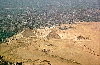
The Western Desert of Egypt is an area of the Sahara that lies west of the river Nile, up to the Libyan border, and south from the Mediterranean Sea to the border with Sudan. It is named in contrast to the Eastern Desert which extends east from the Nile to the Red Sea. The Western Desert is mostly rocky desert, though an area of sandy desert, known as the Great Sand Sea, lies to the west against the Libyan border. The desert covers an area of 680,650 km2 (262,800 sq mi) which is two-thirds of the land area of the country. Its highest elevation is 1,000 m (3,300 ft) in the Gilf Kebir plateau to the far south-west of the country, on the Egypt-Sudan-Libya border. The Western Desert is barren and uninhabited save for a chain of oases which extend in an arc from Siwa, in the north-west, to Kharga in the south. It has been the scene of conflict in modern times, particularly during the Second World War.

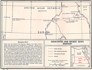
The Egypt–Sudan border is 1,276 km in length and runs from the tripoint with Libya in the west to the Red Sea in the east. The eastern section of the border is subject to a territorial dispute between the two states.