
Mining is the extraction of valuable minerals or other geological materials from the earth, usually from an ore body, lode, vein, seam, reef or placer deposit. These deposits form a mineralized package that is of economic interest to the miner.
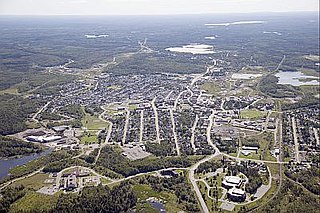
Kirkland Lake is a town and municipality in Timiskaming District in Northeastern Ontario, Canada. The 2016 population, according to Statistics Canada, was 7,981.

Beaconsfield is a former gold mining town near the Tamar River, in the north-east of Tasmania, Australia. It lies 40 kilometres north of Launceston on the West Tamar Highway. It is part of the Municipality of West Tamar.

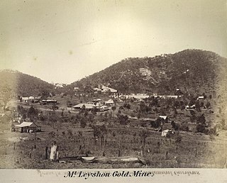
Charters Towers is a town in northern Queensland, Australia. It is 134 kilometres (83 mi) inland (south-west) from Townsville on the Flinders Highway. In 2016 the population was 8,120 people. During the last quarter of the 19th century the town boomed as the rich gold deposits under the city were developed. After becoming uneconomic in the 20th century, profitable mining operations have commenced once again.

Gold mining is the resource extraction of gold by mining.

Obuasi is a Mining Community and town in the southern part of Obuasi Municipal of the Ashanti Region of Ghana. Obuasi is the capital of the Obuasi Municipal which lies south of Ashanti capital city Kumasi 39 miles away south-west of Kumasi or 1 hour 2 minutes road-drive from Obuasi to Kumasi. Obuasi has a settlement population of 175,043 people. Obuasi gold bar mining community has delicate mosaic from the Ashanti people culture of Ashanti and the semi-island exclave Ashantiland. Obuasi wears a ring of hills as its adornment and Obuasi sits quietly albeit industriously on the soil that births the top-9 single richest bullion gold bar gold mining mining|mine on Earth the Obuasi Gold Mine.

The Walhalla railway line was a 2 ft 6 in narrow gauge railway located in Gippsland, Victoria, Australia. The line ran from Moe to the former gold-mining town and popular tourist destination of Walhalla. Construction began in 1904. The line closed in sections from 1944 to 1954.
Muchea is a suburb of the Shire of Chittering. Its postcode is 6501. The towns name comes from the Aboriginal word "Muchela" which means in Nyoongar 'water hole', referring to the abundance of water in Muchea.
The Beaconsfield gold mine collapsed on 25 April 2006 in Beaconsfield, Tasmania, Australia. Of the seventeen people who were in the mine at the time, fourteen escaped immediately following the collapse, one was killed and the remaining two were found alive using a remote-controlled device. These two miners were rescued on 9 May 2006, two weeks after being trapped nearly a kilometre below the surface.

Walhalla was a railway station on the Walhalla narrow gauge line in Gippsland, Victoria, Australia. The station was originally built to serve the Gold Mine town of Walhalla, however just 3 years after the line opened the last gold mine in the town closed.
Teafuaniua is an islet on the north-east of Nukufetau atoll, Tuvalu.

Pulham Market was a railway station on the Waveney Valley Line in Norfolk, England. It was closed for passengers in 1953

The Beaconsfield Mine & Heritage Centre is located in Beaconsfield, Tasmania. It was originally called the Grubb Shaft Gold and Heritage Museum. It was formed in 1972 after discussions were held as to forming a district museum, after which construction of the actual centre began, finally being opened in 1984. It is currently run by the West Tamar Council and holds over 10,000 pieces in its collection.

Gold Rush is a reality television series that airs on Discovery and its affiliates worldwide. The series follows the placer gold mining efforts of various family-run mining companies mostly in the Klondike region of Dawson City, Yukon, Canada, although the prospecting efforts of Todd Hoffman's 316 Mining company have ranged across both South America and western North America.
Bell River, a watercourse that is part of the Macquarie catchment within the Murray–Darling basin, is located in the central west region of New South Wales, Australia.

Surval Montreux is an international all girls boarding school in Montreux, Switzerland.

The mining industry of Mali is dominated by gold extraction which has given it the ranking as the third largest in Africa. Artisanal miners play a large part in the mining of diamonds. The other minerals extracted are rock salt and semiprecious stones. Phosphates are mined in the Tilemsi Valley. In 2013, gold exports were of the order of 67.4 tonnes, nearly a 50% increase over the production in 2012 which is attributed mainly to the contribution of 20.7 tonnes made by artisanal mining. Gold, followed by cotton, is the top export item making a large contribution to the economy of the country.
Seventy Mile is a locality in the Charters Towers Region, Queensland, Australia. In the 2016 census, Seventy Mile had a population of 231 people.


