The Ahaura River is in the South Island of New Zealand. This river drains the western flanks of the Southern Alps and flows into the Grey River.
The Mākākahi River runs through the Manawatū-Whanganui region of the North Island of New Zealand.

Lake Wakatipu is an inland lake in the South Island of New Zealand. It is in the southwest corner of the Otago region, near its boundary with Southland. Lake Wakatipu comes from the original Māori name Whakatipu wai-māori.

Waitaki District is a territorial authority district that is located in the Canterbury and Otago regions of the South Island of New Zealand. It straddles the traditional border between the two regions, the Waitaki River, and its seat is Oamaru.

The Selwyn River flows through the Selwyn District of Canterbury in the South Island of New Zealand.
Hampden, a small town in North Otago, New Zealand, lies close to the North Otago coast, 35 kilometres south of Oamaru and 80 kilometres north of the city of Dunedin, to both of which it is connected by State Highway 1.

Palmerston is a town in Otago in the South Island of New Zealand. Located 50 kilometres to the north of the city of Dunedin, it is the largest town in the Waihemo Ward of the Waitaki District, with a population of 890 residents. Palmerston grew at a major road junction: State Highway 1 links Dunedin and Waikouaiti to the south with Oamaru and Christchurch to the north, while State Highway 85 heads inland to become the principal highway of the Maniototo. The Main South Line railway passes through the town and the Seasider tourist train travels from Dunedin to Palmerston and back once or twice a week. From 1880 until 1989, the town acted as the junction between the main line and a branch line that ran inland, the Dunback and Makareao Branches.

The Hopkins River is in the central South Island of New Zealand. It flows south for 45 kilometres (28 mi) from the Southern Alps / Kā Tiritiri o te Moana into the northern end of Lake Ōhau in the Mackenzie Country.

Lake Tekapo is the second-largest of three roughly parallel lakes running north–south along the northern edge of the Mackenzie Basin in the South Island of New Zealand. It covers an area of 83 km2 (32 sq mi) and is at an altitude of 710 m (2,330 ft) above sea level.
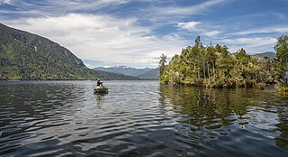
Lake Brunner is the largest lake in the West Coast Region of New Zealand, located 31 km (19 mi) southeast of Greymouth. The main settlement, Moana, is on its northern shore. It is an important settlement and waystation for local Māori. The first Europeans in the area were loggers, and sawmills were an important early industry. Being several kilometres inland from the coast road, it is less frequently visited by tourists than many of the West Coast's scenic highlights, but it is becoming increasingly popular, in part due to its reputation for fishing.

Lake Kaniere is a glacial lake located on the West Coast of New Zealand's South Island. Nearly 200 metres (660 ft) deep, the lake is surrounded on three sides by mountains and mature rimu forest. It is regarded by many as the most beautiful of the West Coast lakes, and is a popular tourist and leisure destination.

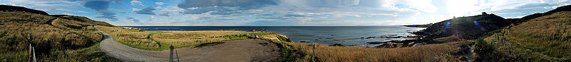
Moeraki is a small fishing village on the east coast of the South Island of New Zealand. It was once the location of a whaling station. In the 1870s, local interests believed it could become the main port for the north Otago area and a railway line, the Moeraki Branch, was built to the settlement and opened in 1877. However, the port could not compete with Oamaru and the lack of traffic as well as stability problems caused by difficult terrain led to the closure of the railway in 1879 after only two years' operation.

Dunback, formerly Waihemo, is a small town in the Otago region of New Zealand. It is located between Palmerston and Ranfurly on Highway 85. It has a population of about 200 people. Most of these people live in the rural areas near the town.
The Dunback and Makareao Branches were two connected branch line railways, part of New Zealand's national rail network. Located in the Otago region of the South Island, both lines were 15 kilometres (9.3 mi) in length and shared the first 11 kilometres (6.8 mi). The Dunback Branch, also known as the Waihemo Branch, opened in 1885 and closed in 1968; the Makareao Branch, also known as the Inch Valley Railway or the Inch Valley Branch, opened in 1900 and operated for 89 years to 1989.
Mākareao is a lightly populated rural locality in the Otago region of New Zealand's South Island. To the west is Dunback and to the south is Inch Valley and the nearest significantly populated town, Palmerston.
Waihemo is a former parliamentary electorate in the Otago region of New Zealand. It existed for two periods and was represented by two Members of Parliament.

The Little Wanganui River is a river of the West Coast Region of New Zealand's South Island. It flows generally west from the slopes of Mount Allen, reaching the Karamea Bight close to the small settlement of Little Wanganui. It is home to a large number of trout.
Morrisons is a small township in the Otago Region of New Zealand's South Island. It is located in the Maniototo, on State Highway 85 between Dunback and Ranfurly, some 45 kilometres southwest of Oamaru.

The Waitakere / Nile River is a river on the West Coast of New Zealand's South Island. It rises in the Paparoa Range and flows through a limestone karst landscape in a roughly northwest direction for its entire length, reaching the Tasman Sea just north of Charleston. The river and its surrounds are a popular tourist destination, particularly for a bush train along the river's canyon and caving through the nearby Metro / Te Ananui Caves. The lower reaches of the river are also a popular fishing spot, particularly for brown trout.
The Horse Range is a range of hills located inland from Oamaru in the South Island of New Zealand. The other side of the range is to the north east of the Shag River valley that contains the lower part of The Pigroot. The Horse Range transitions inland to the higher Kakanui Range.